Ciechanów: Difference between revisions
m r2.7.2) (Robot: Adding lt:Cechanuvas |
SlavPoland (talk | contribs) |
||
| Line 98: | Line 98: | ||
*[http://arch.ciechanow.net.pl Architecture of Ciechanow (only in Polish)] |
*[http://arch.ciechanow.net.pl Architecture of Ciechanow (only in Polish)] |
||
*[http://czasciechanowa.pl Czas Ciechanowa (Local weekly magazine, local press)] |
*[http://czasciechanowa.pl Czas Ciechanowa (Local weekly magazine, local press)] |
||
* [http://www.sztetl.org.pl/en/city/ciechanow/ Jewish Community in Ciechanów] on Virtual Shtetl |
|||
*[http://forumciechanowa.fc.pl/ Forum of city Ciechanów] |
*[http://forumciechanowa.fc.pl/ Forum of city Ciechanów] |
||
*[http://www.ciechanowonline.pl Ciechanow website www.ciechanowonline.pl - all you need to know about Ciechanow, including a contemporary gallery of the city] |
*[http://www.ciechanowonline.pl Ciechanow website www.ciechanowonline.pl - all you need to know about Ciechanow, including a contemporary gallery of the city] |
||
Revision as of 12:44, 24 March 2012
Ciechanów | |
|---|---|
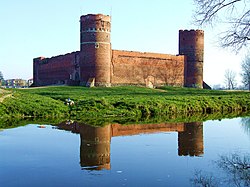
 Castle of the Mazovian Dukes | |
| Country | |
| Voivodeship | Masovian |
| County | Ciechanów County |
| Gmina | Ciechanów (urban gmina) |
| Established | 11th century |
| Town rights | 1400 |
| Government | |
| • Mayor | Waldemar Wardziński |
| Area | |
| • Total | 32.51 km2 (12.55 sq mi) |
| Highest elevation | 151 m (495 ft) |
| Lowest elevation | 116 m (381 ft) |
| Population (2006) | |
| • Total | 45,902 |
| • Density | 1,400/km2 (3,700/sq mi) |
| Time zone | UTC+1 (CET) |
| • Summer (DST) | UTC+2 (CEST) |
| Postal code | 06-400 to 06-413 |
| Area code | +48 023 |
| Car plates | WCI |
| Website | http://www.um.ciechanow.pl |
Ciechanów [t͡ɕɛˈxanuf] is a town in north-central Poland with 45,900 inhabitants (2006). It is situated in Masovian Voivodeship (since 1999). It was previously (1975–98) the capital of Ciechanów Voivodeship.
History
The grad numbered approximately 3,000 armed men.[1]
The settlement is first mentioned in a 1065 document by Bolesław II the Bold handing the land over to the church. In 1254, Ciechanów is mentioned as the seat of a castellany (Rethiborius Castellanus de Techanow (Racibor, Kasztelan Ciechanowa)). In 1400 Janusz I of Czersk granted Ciechanów town privileges.[2] The area eventually become a separate duchy with Casimir I of Warsaw using the title "dominus et heres lub dominus et princeps Ciechanoviensis." By the 14th-15th centuries, the town's population reached 5,000. In the early 20th century, there were just under 12,000 inhabitants.
Before World War II, it was home to a large Jewish community but during the Nazi occupation, in the winter of 1942, the majority of the Jewish commuity were transported to the Red Forest north of the town and murdered by gunfire. During the war many Polish Jews and resistance fighters were executed by the Germans in the castle. The town was annexed by Nazi Germany in 1939 and known as Zichenau in German. It was the capital of Regierungsbezirk Zichenau, a subdivision of the Province of East Prussia. The territory was restored to Poland after the war.
Monuments
- Castle of the Mazovian Dukes from 14th century.
- Farska Hill – fortifiled settlement from 7th century with Neo Gothic belfry from 19th century
- Parish church - Late Gothic object from 16th century.
- Former Monastery church from 16th century and 18th century
- Town Hall from 19th century
- Parish cemetery functioned since 1828.
- Hyperboloid water tower, built in 1972
Education
- Państwowa Wyższa Szkoła Zawodowa
- Wyższa Szkoła Biznesu i Zarządzania
Famous people
- Doda
- Mieczysław Jagielski
- Maria Konopnicka
- Zygmunt Krasiński
- Ignacy Mościcki
- Roza Robota
- Zbigniew Siemiątkowski
- Maria Skłodowska-Curie
- Aleksander Świętochowski
- Stefan Żeromski
- Kasia Struss
References
- ^ Bogusław Gierlach "Zapiski Ciechanowskie, vol. II s. 9-12, MOBN Ciechanów 1977 and "Studia nad archeologią średniowiecznego Mazowsza", Warszawa 1975, s. 24)
- ^ W. Górczyk, Ciechanów- Lokacja i Geneza herbu, In Tempore, Uniwersytet Mikołaja Kopernika,s.3. http://www.intempore.umk.pl/intempore_artykuly/2010/In_Tempore_5_2010.pdf
- Andrzej Rzeplinński
External links
- Wojciech Górczyk, Ciechanów – zarys dziejów do XV w., Kultura i Historia, Uniwersytet Marii Curie Skłodowskiej w lublinie,19/2011, ISSN 1642-9826
- Official homepage
- Architecture of Ciechanow (only in Polish)
- Czas Ciechanowa (Local weekly magazine, local press)
- Jewish Community in Ciechanów on Virtual Shtetl
- Forum of city Ciechanów
- Ciechanow website www.ciechanowonline.pl - all you need to know about Ciechanow, including a contemporary gallery of the city
- Site dedicated to preserving the memory of Ciechanów's Jewish community, including an English translation of the memorial book
- Website of Ciechanow City www.eciechanow.pl - you can find here many news from City, History of Ciechanow, Information where you can eat, sleep and dance.
- Castle of the Dukes of Mazovia in Ciechanów (en)
- Museum of the Mazovian Nobility (en)
52°53′N 20°37′E / 52.883°N 20.617°E


