Great idea to create a separate page for the pre-47 period, I fully endorse that. However, I'm not very happy with the title and the concept of this new page. It just doesn't make much sense to name it this way. Why don't we transform it in a thematic page, rather than a page about an ethnic group. I would suggest either: Fascist Italianization of Littoral Slovenes; or, what would make even more sense: Fascist Italianization of the Julian March (or in the Julian March). [[User:Viator slovenicus|Viator slovenicus]] ([[User talk:Viator slovenicus|talk]]) 15:55, 24 October 2012 (UTC)
Great idea to create a separate page for the pre-47 period, I fully endorse that. However, I'm not very happy with the title and the concept of this new page. It just doesn't make much sense to name it this way. Why don't we transform it in a thematic page, rather than a page about an ethnic group. I would suggest either: Fascist Italianization of Littoral Slovenes; or, what would make even more sense: Fascist Italianization of the Julian March (or in the Julian March). [[User:Viator slovenicus|Viator slovenicus]] ([[User talk:Viator slovenicus|talk]]) 15:55, 24 October 2012 (UTC)
==The map==
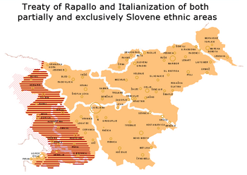
:The map in the article is not exact: many of the areas marked as "partially ethnic Slovene", were in fact inhabited by an exclusively Slovene-speaking population: the Natisone and Upper Torre Valley, Resia, western Karst (including the area between Trieste and San Giovanni di Duino, which was more than 90% Slovene even according to the Italian 1921 census), the Brda (Collio) region, etc. In fact, there were very few ethnically mixed area in the northern part of the Julian March: the city of Trieste, the Muggia Hills, the immediate rural surroundings of Koper, Izola and Piran, the westernmost part of the Brda region (Dolegna del Collio), the town of Gorizia and the suburb of Podgora (all other suburbs were more than 95% Slovene, except Lucinico, which was around 85% Italian/Friulian). In Friuli, the ethnically/linguistically mixed areas were the municipalities of Prepotto, Torreana, Montenars and some villages between Cividale and San Pietro al Natisone. Here, I'm using data from the Austrian 1910 census (but also the Italian 1921 census shows pretty much the same data). [[User:Viator slovenicus|Viator slovenicus]] ([[User talk:Viator slovenicus|talk]]) 00:36, 31 October 2012 (UTC)
:The map in the article is not exact: many of the areas marked as "partially ethnic Slovene", were in fact inhabited by an exclusively Slovene-speaking population: the Natisone and Upper Torre Valley, Resia, western Karst (including the area between Trieste and San Giovanni di Duino, which was more than 90% Slovene even according to the Italian 1921 census), the Brda (Collio) region, etc. In fact, there were very few ethnically mixed area in the northern part of the Julian March: the city of Trieste, the Muggia Hills, the immediate rural surroundings of Koper, Izola and Piran, the westernmost part of the Brda region (Dolegna del Collio), the town of Gorizia and the suburb of Podgora (all other suburbs were more than 95% Slovene, except Lucinico, which was around 85% Italian/Friulian). In Friuli, the ethnically/linguistically mixed areas were the municipalities of Prepotto, Torreana, Montenars and some villages between Cividale and San Pietro al Natisone. Here, I'm using data from the Austrian 1910 census (but also the Italian 1921 census shows pretty much the same data). [[User:Viator slovenicus|Viator slovenicus]] ([[User talk:Viator slovenicus|talk]]) 00:36, 31 October 2012 (UTC)
::Indeed, the exlusively Slovene-speaking areas were even larger than it is drawn on the current version of the map. The map [[File:Treaty_of_Rapallo.png|left|350px]] is drawn '''in favour of Italians''' but an anonymous Italian from Brescia removed it in his edit [http://en.wikipedia.org/w/index.php?title=Slovene_minority_in_Italy_%281920-1947%29&diff=next&oldid=520761297 here], calling it a "fantasy map". What on earth is he going to call it after the corrected map shows the exclusive Slovene-speaking areas under Italianization were even larger?! [[User:DancingPhilosopher|DancingPhilosopher]] <sup>[[User talk:DancingPhilosopher|my talk]]</sup> 18:22, 4 November 2012 (UTC)
This article is within the scope of WikiProject Slovenia, a collaborative effort to improve the coverage of Slovenia on Wikipedia. If you would like to participate, please visit the project page, where you can join the discussion and see a list of open tasks.SloveniaWikipedia:WikiProject SloveniaTemplate:WikiProject SloveniaSlovenia articles
This article is within the scope of WikiProject Italy, a collaborative effort to improve the coverage of Italy on Wikipedia. If you would like to participate, please visit the project page, where you can join the discussion and see a list of open tasks.ItalyWikipedia:WikiProject ItalyTemplate:WikiProject ItalyItaly articles
Great idea to create a separate page for the pre-47 period, I fully endorse that. However, I'm not very happy with the title and the concept of this new page. It just doesn't make much sense to name it this way. Why don't we transform it in a thematic page, rather than a page about an ethnic group. I would suggest either: Fascist Italianization of Littoral Slovenes; or, what would make even more sense: Fascist Italianization of the Julian March (or in the Julian March). Viator slovenicus (talk) 15:55, 24 October 2012 (UTC)[reply]
The map
The map in the article is not exact: many of the areas marked as "partially ethnic Slovene", were in fact inhabited by an exclusively Slovene-speaking population: the Natisone and Upper Torre Valley, Resia, western Karst (including the area between Trieste and San Giovanni di Duino, which was more than 90% Slovene even according to the Italian 1921 census), the Brda (Collio) region, etc. In fact, there were very few ethnically mixed area in the northern part of the Julian March: the city of Trieste, the Muggia Hills, the immediate rural surroundings of Koper, Izola and Piran, the westernmost part of the Brda region (Dolegna del Collio), the town of Gorizia and the suburb of Podgora (all other suburbs were more than 95% Slovene, except Lucinico, which was around 85% Italian/Friulian). In Friuli, the ethnically/linguistically mixed areas were the municipalities of Prepotto, Torreana, Montenars and some villages between Cividale and San Pietro al Natisone. Here, I'm using data from the Austrian 1910 census (but also the Italian 1921 census shows pretty much the same data). Viator slovenicus (talk) 00:36, 31 October 2012 (UTC)[reply]
Indeed, the exlusively Slovene-speaking areas were even larger than it is drawn on the current version of the map. The map is drawn in favour of Italians but an anonymous Italian from Brescia removed it in his edit here, calling it a "fantasy map". What on earth is he going to call it after the corrected map shows the exclusive Slovene-speaking areas under Italianization were even larger?! DancingPhilosophermy talk18:22, 4 November 2012 (UTC)[reply]