Bori Bunder: Difference between revisions
Appearance
Content deleted Content added
No edit summary |
Adityagada (talk | contribs) added infobox |
||
| Line 1: | Line 1: | ||
{{Infobox settlement |
|||
| name = Bori Bunder |
|||
| native_name = |
|||
| native_name_lang = mr |
|||
| other_name = |
|||
| settlement_type = Neighbourhood |
|||
| nickname = |
|||
| map_alt = |
|||
| map_caption = |
|||
| pushpin_map = Mumbai |
|||
| pushpin_label_position = |
|||
| pushpin_map_alt = |
|||
| pushpin_map_caption = |
|||
| latd = 18.9400 |
|||
| latm = |
|||
| lats = |
|||
| latNS = N |
|||
| longd = 72.8353 |
|||
| longm = |
|||
| longs = |
|||
| longEW = E |
|||
| coordinates_display = inline,title |
|||
| subdivision_type = Country |
|||
| subdivision_name = India |
|||
| subdivision_type1 = [[States and territories of India|State]] |
|||
| subdivision_name1 = [[Maharashtra]] |
|||
| subdivision_type2 = [[List of districts of India|District]] |
|||
| subdivision_name2 = Mumbai City |
|||
| subdivision_type3 = Metro |
|||
| subdivision_name3 = Mumbai |
|||
| established_title = <!-- Established --> |
|||
| established_date = |
|||
| founder = |
|||
| named_for = |
|||
| government_type = |
|||
| governing_body = |
|||
| unit_pref = Metric |
|||
| area_footnotes = |
|||
| area_rank = |
|||
| area_total_km2 = |
|||
| elevation_footnotes = |
|||
| elevation_m = |
|||
| population_total = |
|||
| population_as_of = |
|||
| population_rank = |
|||
| population_density_km2 = auto |
|||
| population_demonym = |
|||
| population_footnotes = |
|||
| demographics_type1 = Languages |
|||
| demographics1_title1 = Official |
|||
| demographics1_info1 = [[Marathi language|Marathi]] |
|||
| timezone1 = [[Indian Standard Time|IST]] |
|||
| utc_offset1 = +5:30 |
|||
| area_code_type = |
|||
| area_code = 022 |
|||
| blank1_name_sec1 = Civic agency |
|||
| blank1_info_sec1 = [[Brihanmumbai Municipal Corporation|BMC]] |
|||
| postal_code_type = [[Postal Index Number|PIN]] |
|||
| postal_code = 400001<ref name="pcode">{{cite web|url=https://pincode.org.in/400001|title=Pin code : Bori Bunder, Mumbai |
|||
|accessdate=9 February 2015|publisher=pincode.org.in}}</ref> |
|||
| registration_plate = MH 01 |
|||
| website = |
|||
| footnotes = |
|||
}} |
|||
{{Coord|18.9400|72.8353|region:IN|display=title}} |
{{Coord|18.9400|72.8353|region:IN|display=title}} |
||
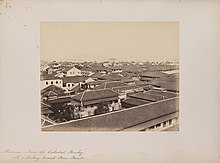
[[File:Panorama - From the Cathedral, Bombay. No. 4. Looking towards Boree Bunder (12675171104).jpg|thumb|Bori Bunder as seen from St. Thomas Cathedral (c. 1855-1862).]] |
[[File:Panorama - From the Cathedral, Bombay. No. 4. Looking towards Boree Bunder (12675171104).jpg|thumb|Bori Bunder as seen from St. Thomas Cathedral (c. 1855-1862).]] |
||
Revision as of 06:47, 9 February 2015
Bori Bunder | |
|---|---|
Neighbourhood | |
| Country | India |
| State | Maharashtra |
| District | Mumbai City |
| Metro | Mumbai |
| Languages | |
| • Official | Marathi |
| Time zone | UTC+5:30 (IST) |
| PIN | 400001[1] |
| Area code | 022 |
| Vehicle registration | MH 01 |
| Civic agency | BMC |
18°56′24″N 72°50′07″E / 18.9400°N 72.8353°E

Bori Bunder (alternatively "Bori Bandar") was one of the areas along the Eastern shore line of Mumbai, India.
Background
This place was used as a storehouse for goods imported and exported from Mumbai. In the native slang, 'Bori' mean sack and 'Bandar' means Bhandaar or store; Bandar also means port; So Bori Bunder literally means a place where sacks are stored.
Transport
In the 1850s, the Great Indian Peninsular Railway built its railway terminus in this area and the station took its name as Bori Bunder.[2]
See also
References
- ^ "Pin code : Bori Bunder, Mumbai". pincode.org.in. Retrieved 9 February 2015.
- ^ "Rail museum in Lonavala mooted". Daily News and Analysis. 27 September 2008. Retrieved 1 May 2011.
