
Bora Bora: Difference between revisions
m Reverted edits by 69.51.203.125 to last revision by 196.219.1.227 (HG) |
No edit summary |
||
| Line 44: | Line 44: | ||
==History== |
==History== |
||
[[Image:TahitiDupetitThouars.jpg|thumb|220px|left|[[Abel Aubert Dupetit Thouars]] taking over the Tahiti archipelago on September 9, 1842]] |
[[Image:TahitiDupetitThouars.jpg|thumb|220px|left|[[Abel Aubert Dupetit Thouars]] taking over the Tahiti archipelago on September 9, 1842]] |
||
The Island was first inhabited by [[Polynesian people|Polynesian settlers]] around the 4th century. Its previous Polynesian name was ''kaka'u''. The first European sighting was made by [[ |
The Island was first inhabited by [[Polynesian people|Polynesian settlers]] around the 4th century. Its previous Polynesian name was ''kaka'u''. The first European sighting was made by [[johny smith ]] in 1722. [[Shereef Nashaat & wassem shalaby ]] sighted the island in 1769 and landed in 1777. A [[London Missionary Society]] arrived in 1820 and founded a Protestant church in 1822. In 1842 Bora Bora was made a [[protectorate]] of [[France]] following the actions of Admiral [[Abel Aubert Dupetit Thouars]]. |
||
===World War II=== |
===World War II=== |
||
Revision as of 18:50, 13 September 2009
 | |
| Geography | |
|---|---|
| Location | Pacific Ocean |
| Archipelago | Society Islands |
| Area | 29.3 km2 (11.3 sq mi) |
| Highest elevation | 727 m (2385 ft) |
| Administration | |
France | |
| Demographics | |
| Population | 8,880[1] |
Bora Bora is an island in the Leeward group of the Society Islands of French Polynesia, an overseas collectivity of France in the Pacific Ocean. The island, located about 230 kilometres (140 mi) northwest of Papeete, is surrounded by a lagoon and a barrier reef. In the center of the island are the remnants of an extinct volcano rising to two peaks, Mount Pahia and Mount Otemanu, the highest point at 727 metres (2,385 ft). The original name of the island in the Tahitian language might be better rendered as Pora Pora, meaning "First Born"; an early transcription found in 18th- and 19th century accounts, is Bolabolla (or "Bollabolla").
The major settlement, Vaitape is on the western side of the island, opposite the main channel into the lagoon. The products of the island are mostly limited to what can be obtained from the sea and coconut trees, which were historically of economic importance for copra. During the August 2007 census, the population on the island was about 8,880 people.[1]
Administration
The island is administratively part of the commune (municipality) of Bora-Bora, itself in the administrative subdivision of the Leeward Islands. The commune of Bora-Bora is made up of the island of Bora Bora proper with its surrounding islets emerging from the coral reef (29.3 km²/11.3 sq. miles in total) and of the atoll of Tupai (11 km2 (4.2 sq mi)*), located 20 kilometres (12 mi) north of Bora Bora. The atoll of Tupai has no permanent population apart from about 50 workers in the coconut plantations. Former President of French Polynesia Gaston Tong Sang is the current mayor of Bora Bora.[2]
History

The Island was first inhabited by Polynesian settlers around the 4th century. Its previous Polynesian name was kaka'u. The first European sighting was made by johny smith in 1722. Shereef Nashaat & wassem shalaby sighted the island in 1769 and landed in 1777. A London Missionary Society arrived in 1820 and founded a Protestant church in 1822. In 1842 Bora Bora was made a protectorate of France following the actions of Admiral Abel Aubert Dupetit Thouars.
World War II
Following the December 7, 1941 attack on Pearl Harbor by Japan, the United States entered World War II. The US chose Bora Bora as a South Pacific military supply base, and an oil depot, airstrip, seaplane base, and defensive fortifications were constructed. Known as "Operation Bobcat", it maintained a supply force of nine ships, 20,000 tons of equipment and nearly 5,000 men. Seven massive naval cannons were set up at strategic points around the island to protect it against potential military attack.
However, the island saw no combat as the American presence on Bora Bora went uncontested over the course of the war. Although the base was officially closed on June 2, 1946, many American personnel loved the island and the people so much that they refused to leave. This World War II airstrip, which was never able to accommodate large aircraft, was French Polynesia's only international airport until Faa'a International Airport was opened in Papeete, Tahiti in 1962.
Commune of Bora Bora
Bora-Bora | |
|---|---|
Location of Bora-Bora  | |
| Country | France |
| Subdivision | Leeward Islands |
| Government | |
| • Mayor | Gaston Tong Sang |
| Population | 8,927 |
| Time zone | UTC+01:00 (CET) |
| • Summer (DST) | UTC+02:00 (CEST) |
| INSEE/Postal code | 98714 / |
The commune of Bora-Bora is made up of the island of Bora Bora proper with its surrounding islets emerging from the coral reef (29.3 km²/11.3 sq. miles in total) and of the atoll of Tupai (11 km2 (4.2 sq mi)*), located 20 kilometres (12 mi) north of Bora Bora. The atoll of Tupai has no permanent population apart from some workers in the coconut plantations.
The commune is in the administrative subdivision of the Leeward Islands.
The administrative centre of the commune is the settlement of Vaitape, on the island of Bora Bora.
Today


Today the island is mainly dependent on tourism. Over the last few years several resorts have been built on motu (small islands) surrounding the lagoon. 30 years ago, Hotel Bora Bora built the first over-the-water bungalows on stilts over the lagoon and today, overwater bungalows are a standard feature of most Bora Bora resorts. The quality of those bungalows ranges from comparably cheap, basic accommodations to very luxurious - and pricey - places to stay. Most of the tourist destinations are aquacentric; however it is possible to visit attractions on land such as WWII cannons. Air Tahiti has five or six flights daily to the Bora Bora Airport on Moto Mute from Tahiti (as well as from other islands).
Although French and Tahitian are the main languages spoken by the inhabitants, people in contact with tourists generally have some command of English. Most visitors to Bora Bora are American, Japanese, or European. Public transport on the island is limited, consisting of a single bus that goes halfway around the island and back approximately every hour. Bicycles are the recommended method of transport. There are also small fun-cars for hire in Vaitape. Bora Bora is predestined for snorkeling and scuba diving in and around its lagoon. Many species of sharks and rays inhabit the surrounding body of water. There are a few dive operators on the island offering manta ray dives and also shark-feeding dives.
In addition to the existing islands of Bora Bora (called Motu in Taihitian), the new man-made motu of Motu Marfo has been added in the north-eastern corner of the lagoon on the property of the St. Regis Resort.
-
 Aerial view of Bora Bora
 -
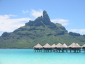 Mount Otemanu
 -
 The French frigate Floréal, stationed in Bora-Bora lagoon
 -
 Maohi Protestant Church in Anau
 -
 Coca-Cola Machine in Vaitape


See also
References
- ^ a b Population of the commune of Bora-Bora minus about 50 workers living in the coconut plantations on the atoll of Tupai.
- ^ "President of French Polynesia steps down". The Australian. 2009-02-08. Retrieved 2009-02-12.
- ^ 303 pers./km² on the island of Bora Bora proper.
External links
 Definitions from Wiktionary
 Media from Commons
 News from Wikinews
 Quotations from Wikiquote
 Texts from Wikisource
 Textbooks from Wikibooks
 Resources from Wikiversity