
Nicopolis ad Istrum: Difference between revisions
Luckas-bot (talk | contribs) m robot Adding: sv:Nicopolis ad Istrum |
No edit summary |
||
| Line 1: | Line 1: | ||
{{otherplaces2|Nicopolis}} |
{{otherplaces2|Nicopolis}} |
||
[[File:Nikopolis ad Istrum overview Klearchos.jpg|right|thumb|320px|Nicopolis ad Istrum]] |
[[File:Nikopolis ad Istrum overview Klearchos.jpg|right|thumb|320px|Nicopolis ad Istrum]] |
||
'''Nicopolis ad Istrum''' ({{lang-el|Νικόπολις η προς Ίστρον}}) was a [[Ancient Rome|Roman]] and Early [[Byzantine Empire|Byzantine]] town founded by Emperor [[Trajan]] around 101–106, at the junction of the Iatrus ([[Yantra River|Yantra]]) and the [[Rositsa]] rivers, in memory of his victory over the [[Dacia]]ns. Its ruins are located at the village of [[Nikyup]], 20 km north of [[Veliko Tarnovo]] in northern [[Bulgaria]]. The town reached its |
'''Nicopolis ad Istrum''' ({{lang-el|Νικόπολις η προς Ίστρον}}) was a [[Ancient Rome|Roman]] and Early [[Byzantine Empire|Byzantine]] town founded by Emperor [[Trajan]] around 101–106, at the junction of the Iatrus ([[Yantra River|Yantra]]) and the [[Rositsa]] rivers, in memory of his victory over the [[Dacia]]ns. Its ruins are located at the village of [[Nikyup]], 20 km north of [[Veliko Tarnovo]] in northern [[Bulgaria]]. The town reached its floruit during the reigns of Trajan, [[Hadrian]], the [[Antonines]] and the [[Severan dynasty]]. |
||
The classical town was planned according to the orthogonal system. The network of streets, the forum surrounded by an Ionic colonnade and many buildings, a two-nave room later turned into a basilica and other public buildings have been uncovered. The rich architectures and sculptures show a similarity with those of the ancient towns in Asia Minor. Nicopolis ad Istrum had issued coins, bearing images of its own public buildings.<ref name=unesco>UNESCO.ORG</ref> |
The classical town was planned according to the orthogonal system. The network of streets, the forum surrounded by an Ionic colonnade and many buildings, a two-nave room later turned into a basilica and other public buildings have been uncovered. The rich architectures and sculptures show a similarity with those of the ancient towns in Asia Minor. Nicopolis ad Istrum had issued coins, bearing images of its own public buildings.<ref name=unesco>UNESCO.ORG</ref> |
||
Revision as of 11:11, 20 July 2010

Nicopolis ad Istrum (Greek: Νικόπολις η προς Ίστρον) was a Roman and Early Byzantine town founded by Emperor Trajan around 101–106, at the junction of the Iatrus (Yantra) and the Rositsa rivers, in memory of his victory over the Dacians. Its ruins are located at the village of Nikyup, 20 km north of Veliko Tarnovo in northern Bulgaria. The town reached its floruit during the reigns of Trajan, Hadrian, the Antonines and the Severan dynasty.
The classical town was planned according to the orthogonal system. The network of streets, the forum surrounded by an Ionic colonnade and many buildings, a two-nave room later turned into a basilica and other public buildings have been uncovered. The rich architectures and sculptures show a similarity with those of the ancient towns in Asia Minor. Nicopolis ad Istrum had issued coins, bearing images of its own public buildings.[1]
In 447 AD, the town was destroyed by Attila's Huns.[2] Perhaps it was already abandoned before the early 400s.[3] In the 6th century, it was rebuilt as a powerful fortress enclosing little more than military buildings and churches, following a very common trend for the cities of that century in the Danube area.[4] The largest area of the extensive ruins (21.55 hectares) of the classical Nicopolis was not reoccupied since the fort covered only one fourth of it (5.75 hectares), in the southeastern corner.[5] The town became an episcopal centre during the early Byzantine period. It was finally destroyed by the Avar invasions at the end of the 6th century. A Bulgarian medieval settlement arose upon its ruins later (10th-14th century).[1]
Nicopolis ad Istrum can be said to have been the birthplace of Germanic literary tradition. In the 4th century, the Gothic bishop, missionary and translator Ulfilas (Wulfila) obtained permission from Emperor Constantius II to immigrate with his flock of converts to Moesia and settle near Nicopolis ad Istrum in 347-8.[6] There, he invented the Gothic alphabet and translated the Bible from Greek to Gothic.[7]
Gallery
-
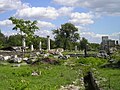 Overview of the ruins of Nicopolis ad Istrum
 -
 A pediment with a relief image
 -
 A Roman street, one of the city's main streets running north-south
 -
 The main city sewers


Notes
References
- Burns, Thomas, S. Barbarians Within the Gates of Rome: A Study of Roman Military Policy and the Barbarians, ca. 375-425 A.D., Indiana University Press, 1994. ISBN 0-253-31288-4
- Curta, Florin. The Making of the Slavs. History and Archaeology of the Lower Danube Region c.500-700, Cambridge University Press, 2001, ISBN 0-521-03615-1
- Liebeschuetz, J.H.W.G. The Decline and Fall of the Roman City, Oxford University Press, 2001. ISBN 978-0-19-926109-3
- The ancient town of Nicopolis ad Istrum at UNESCO.ORG
Further reading
Poulter, Andrew. Nicopolis ad Istrum: A Roman, Late Roman and Early Byzantine City (Excavations 1985-1992), Society for the Promotion of Roman Studies, London, 1995. ISBN 0-907-76420-7