
St George, Bristol: Difference between revisions
→Facilities: grammar |
|||
| Line 59: | Line 59: | ||
{{unreferenced|section|date=August 2014}} |
{{unreferenced|section|date=August 2014}} |
||
[[Image:The A431 Summerhill Road.jpg|thumb|left|The A431 Summerhill Road and the junction with Marling Road, St George, Bristol.]] |
[[Image:The A431 Summerhill Road.jpg|thumb|left|The A431 Summerhill Road and the junction with Marling Road, St George, Bristol.]] |
||
The St George Fountain is a [[Victorian architecture|Victorian]] drinking fountain which divides the main Church Road which forks at this point to [[Kingswood, South Gloucestershire|Kingswood]] and [[Hanham]]. The road was also once the boundary between Bristol and [[Gloucestershire]]. Adjacent to this was the Parish Church of St. George, |
The St George Fountain is a [[Victorian architecture|Victorian]] drinking fountain which divides the main Church Road which forks at this point to [[Kingswood, South Gloucestershire|Kingswood]] and [[Hanham]]. The road was also once the boundary between Bristol and [[Gloucestershire]]. Adjacent to this was the Parish Church of St. George, which has since been demolished and sheltered housing has been built on the site. |
||
Not far from this spot is the St. George Police Station. It is no longer in use, but was converted to flats |
Not far from this spot is the St. George Police Station. It is no longer in use, but was converted to flats, so the building has been preserved. |
||
Opposite this, there is a grassed area and on this site used to be the Park Picture House. Another local facility demolished and never replaced, this was a great favourite with children who used to attend the 9d rush on a Saturday morning and they always left desperate not to miss the following week as the final picture was always a serial, which had left the hero strapped to a train track or dangling over some life-threatening piece of machinery. |
Opposite this, there is a grassed area and on this site used to be the Park Picture House. Another local facility demolished and never replaced, this was a great favourite with children who used to attend the 9d rush on a Saturday morning and they always left desperate not to miss the following week as the final picture was always a serial, which had left the hero strapped to a train track or dangling over some life-threatening piece of machinery. |
||
| Line 67: | Line 67: | ||
St George Public Library is a prefabricated style building which replaced the previous stone built Victorian building, demolished when it was fashionable to pull down older buildings. |
St George Public Library is a prefabricated style building which replaced the previous stone built Victorian building, demolished when it was fashionable to pull down older buildings. |
||
Recently, there has been much televised about the palace at [[Kew Gardens]] and it is interesting to note the similarities in design of this building and the old red brick St George Higher Grade School, later St George Grammar School and finally St George Comprehensive School. |
Recently, there has been much televised about the palace at [[Kew Gardens]] and it is interesting to note the similarities in design of this building and the old red brick St George Higher Grade School, later St George Grammar School and finally St George Comprehensive School. It is now a [[Sikh]] temple and a [[gym]]. |
||
==Sport and leisure== |
==Sport and leisure== |
||
Revision as of 08:06, 15 February 2015
| St George | |
|---|---|
 Boundaries of St George West and East wards, shown within Bristol. | |
| Population | 11,348 (East)[1] 10,929 (West)[2] |
| OS grid reference | ST626734 |
| Unitary authority | |
| Ceremonial county |
|
| Region | |
| Country | England |
| Sovereign state | United Kingdom |
| Post town | BRISTOL |
| Postcode district | BS |
| Dialling code | 0117 |
| Police | Avon and Somerset |
| Fire | Avon |
| Ambulance | South Western |
| UK Parliament | |
St. George is a district of Bristol, England on the edge of the inner city.
History
St George was originally in Gloucestershire. It became a civil parish (formally known as Bristol St George) in 1866, and briefly an urban district from 1894 to 1898. The parish and urban district were absorbed into Bristol in 1898.[3]
The area was once the end of the tram line from the city of Bristol, the terminus being in Beaconsfield Road.
St. George was once a mining area but now only pit names remain to remind everyone of this district's mining history, i.e., Deep Pit Road.
John Armitstead well known as a coal adventurer — a colliery proprietor had a pit between Church Road and Whitehall Road, St George where he installed a pumping engine for raising coal. Power was generated from water by means of a fire and ergo the device was called a Fire-engine. It stood on Colt’s or Boulter’s Ground but the land came to be known as the Engine Ground. To this day, a pub in the area is called the Fire Engine.
In the modern era St George is known for its many shops and pubs.
The St George Neighbourhood Partnership - www.stgeorgenp.org.uk - is very active in helping to improve facilities in the St George East and St George West wards of Bristol.
Troopers' Hill
Located on the outskirts of Bristol, local tradition has it that the Parliamentary army, under the command of Sir Thomas Fairfax, camped on Troopers' Hill prior to the siege of Bristol in 1645. It has also been suggested that the ditch between the hill and the allotments was dug at this time as a defensive earthworks. It is known that the army approached Bristol via Keynsham and Hanham and it is possible therefore that Troopers' Hill, with its views of the city, was used while the Parliamentary army was headquartered at Hanham.
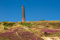
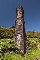
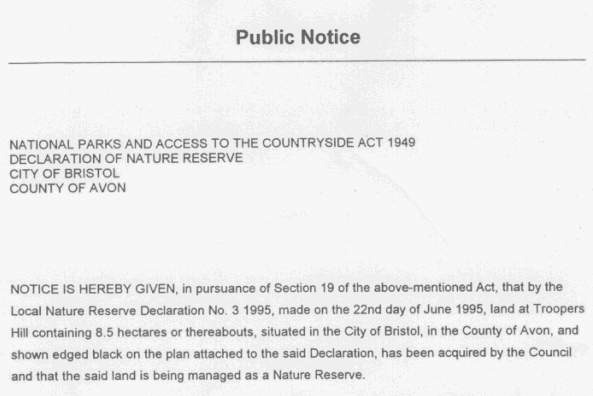
Troopers' Hill is a local landmark, and was a mining area from the early 19th century (coal) until its closure in 1904 when the last fireclay mines were abandoned.[4] It was declared as a Local Nature Reserve (LNR) on 22 June 1995.[5]
-
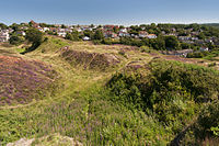
 View from Troopers' Hill overlooking Bristol and the River Avon
 -
 A view of the Grade II listed chimney on top of Troopers' Hill, a reminder of the area's history.


- Troopers Hill
-
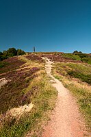
 Troopers' Hill View
 -
 Troopers' Hill View
 -
 Troopers' Hill View
 -
 Troopers' Hill View
 -
 Troopers' Hill View
 -
 Troopers' Hill View


Facilities

The St George Fountain is a Victorian drinking fountain which divides the main Church Road which forks at this point to Kingswood and Hanham. The road was also once the boundary between Bristol and Gloucestershire. Adjacent to this was the Parish Church of St. George, which has since been demolished and sheltered housing has been built on the site.
Not far from this spot is the St. George Police Station. It is no longer in use, but was converted to flats, so the building has been preserved.
Opposite this, there is a grassed area and on this site used to be the Park Picture House. Another local facility demolished and never replaced, this was a great favourite with children who used to attend the 9d rush on a Saturday morning and they always left desperate not to miss the following week as the final picture was always a serial, which had left the hero strapped to a train track or dangling over some life-threatening piece of machinery.
St George Public Library is a prefabricated style building which replaced the previous stone built Victorian building, demolished when it was fashionable to pull down older buildings.
Recently, there has been much televised about the palace at Kew Gardens and it is interesting to note the similarities in design of this building and the old red brick St George Higher Grade School, later St George Grammar School and finally St George Comprehensive School. It is now a Sikh temple and a gym.
Sport and leisure
St George has two Non-League football club Roman Glass St George F.C. who play at Bell Hill on Whiteway Road and Nicholas Wanderers F.C. who play on the only public pitches within St George at Dundridge Park.
St George also has a Junior Football Club Nicholas Wanderers J.F.C. who compete in both the Hanham Minor and Avon Youth Leagues Nicholas Wanderers JFC.
Local churches
- Crofts End Church,
- St George Baptist
- Lighthouse Church, Bristol
- Bridge Community Church
- [1]
Regeneration
St George was included in areas covered by the 2004 Redfield Action Plan by David Wilson Partnership and 2md, commissioned by Bristol East Side Traders and Community at Heart which outlined a number of measures to improve social and economic conditions.
See also
References
- ^ "St George East" (PDF). 2001 Census Ward Information Sheet. Retrieved 2007-02-21.
- ^ "St George West" (PDF). 2001 Census Ward Information Sheet. Retrieved 2007-02-21.
- ^ Vision of Britain: St George UD
- ^ "Friends of Troopers Hill". Retrieved 2009-04-21.
- ^ "Public Notice". Retrieved 2009-04-21.