
Talk:Control of cities during the Syrian civil war: Difference between revisions
→Yellow: new section |
|||
| Line 316: | Line 316: | ||
Could you please think over the "Yellow" color ? It is indeed very hard to distinguish this colr in a backgroung map which ist almost yellow ( light Yellowish beige). I thing a more forceful color ( yellowish orange) ist much better to see and is not far from this accustomed yellow.to compare: |
Could you please think over the "Yellow" color ? It is indeed very hard to distinguish this colr in a backgroung map which ist almost yellow ( light Yellowish beige). I thing a more forceful color ( yellowish orange) ist much better to see and is not far from this accustomed yellow.to compare: |
||
[http://fs5.directupload.net/images/151127/3xdhqcqv.png compare] |
[http://fs5.directupload.net/images/151127/3xdhqcqv.png compare] <br /> |
||
<gallery> |
|||
http://fs5.directupload.net/images/151127/3xdhqcqv.png|Compare Yello/Orange-Yellow |
|||
. <br /> |
|||
</gallery> |
|||
--[[Special:Contributions/212.75.52.4|212.75.52.4]] ([[User talk:212.75.52.4|talk]]) 08:45, 27 November 2015 (UTC)MapMaker |
--[[Special:Contributions/212.75.52.4|212.75.52.4]] ([[User talk:212.75.52.4|talk]]) 08:45, 27 November 2015 (UTC)MapMaker |
||
Revision as of 08:47, 27 November 2015
| This article was nominated for deletion on 23 July 2015. The result of the discussion was keep. |
| This is the talk page for discussing improvements to the Control of cities during the Syrian civil war article. This is not a forum for general discussion of the article's subject. |
Article policies
|
| Find sources: Google (books · news · scholar · free images · WP refs) · FENS · JSTOR · TWL |
| This page is not a forum for general discussion about Control of cities during the Syrian civil war. Any such comments may be removed or refactored. Please limit discussion to improvement of this article. You may wish to ask factual questions about Control of cities during the Syrian civil war at the Reference desk. |
| This article is of interest to the following WikiProjects: | |||||||||||||||||||||||||||||||||||||||||||||||||||||||
Please add the quality rating to the {{WikiProject banner shell}} template instead of this project banner. See WP:PIQA for details.
Please add the quality rating to the {{WikiProject banner shell}} template instead of this project banner. See WP:PIQA for details.
Please add the quality rating to the {{WikiProject banner shell}} template instead of this project banner. See WP:PIQA for details.
| |||||||||||||||||||||||||||||||||||||||||||||||||||||||


.svg)

| To help centralise discussions and keep related topics together, Template talk:Syrian Civil War detailed map redirects here. |
Template:Syrian Civil War sanctions
 | Rules for Editing the Map
1- A reliable source for that specific edit should be provided.
2- Copying from maps is strictly prohibited. Maps from mainstream media are approximate and therefore unreliable for any edit. Maps from amateur sources are below the standards of Wikipedia for any edit. They violate WP:RS and WP:CIRCULAR.
|
|
Index 1, 2, 3, 4, 5, 6, 7, 8, 9, 10 |
|
This page has archives. Sections older than 7 days may be automatically archived by Lowercase sigmabot III when more than 3 sections are present. |
Kurds/ SDF
I want to change the description of the yellow marks/dots from "Kurds" to "Kurds & SDF". Anyone has an opinion on this? If more FSA-factions join SDF 1 2 3 4 maybe there need to be bigger changes on the map... I have no idea but I´m raising the question. Rhocagil (talk) 01:24, 19 November 2015 (UTC)
- We have Syrian Democratic Forces in Hasakah most of which it is a Kurdish forces which fight against ISIS with with a little help some rebels. Here Al-Hawl offensive And we have Syrian Democratic Forces which fight afainst ISIS in Idlib and Aleppo Governorates and they also fight against Syrian troops and their allies. Their difference is that the first fights only against ISIS while the second fights against ISIS and against the Syrian army. So don't need to change anything on the map. 95.134.186.238 (talk) 15:16, 19 November 2015 (UTC)
- No, we should change all villages captured by SDF to Green-Yellow symbol.Prohibited Area (talk) 15:38, 20 November 2015 (UTC)
- Prohibited Area I think I agree with you. But I do think that in addition we should put up this icon (yellow+lime) on the description-board under the map as SDF.Rhocagil (talk) 22:58, 20 November 2015 (UTC)
- Rhocagil (talk) No, because Yellow-Green also represents Euphrates Volcano. This would also encourage the argument that, for instance, Green-Grey should be labelled as 'Jaish al Fatah' or 'Fatah Halab' etc. If a coalition of forces capture a village the village should represent this with the respective symbol for mixed control. We should not change these symbols for mixed control so that they exclusively satisfy conditions of control by one form of coalition, given there are hundreds in Syria.Prohibited Area (talk) 11:37, 21 November 2015 (UTC)
- Prohibited Area you are right. Rhocagil (talk) 13:13, 21 November 2015 (UTC)
- Rhocagil (talk) No, because Yellow-Green also represents Euphrates Volcano. This would also encourage the argument that, for instance, Green-Grey should be labelled as 'Jaish al Fatah' or 'Fatah Halab' etc. If a coalition of forces capture a village the village should represent this with the respective symbol for mixed control. We should not change these symbols for mixed control so that they exclusively satisfy conditions of control by one form of coalition, given there are hundreds in Syria.Prohibited Area (talk) 11:37, 21 November 2015 (UTC)
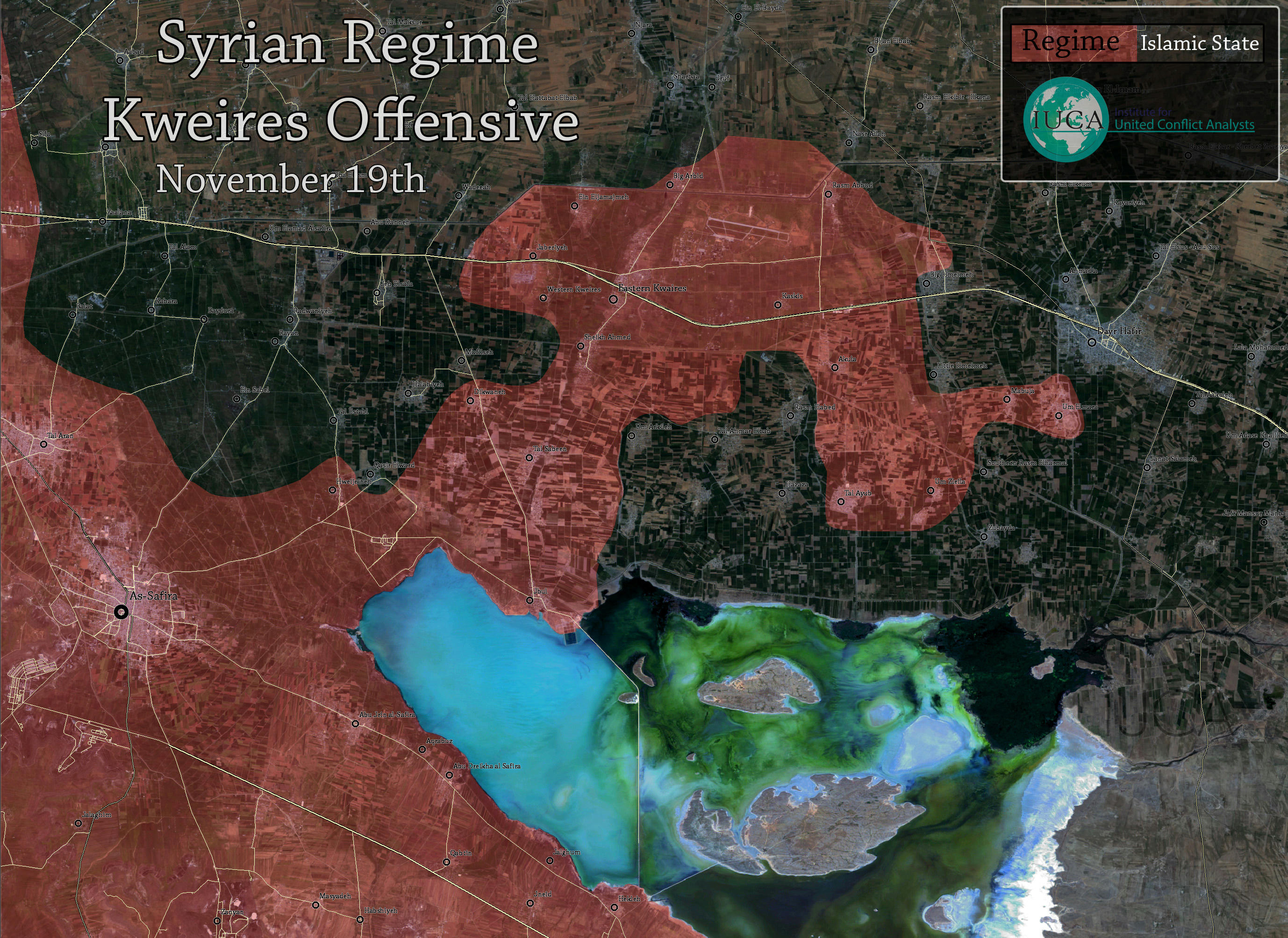
Jabboul Lake Front
These locations can be changed to red (Government control)
1:‘Umm Zilaylah
2: Tal Ayyoub
3:‘Umm Al-Marra
4: hilltop of Tal Humaymah
Here the location map:3 recaptured villages
Source : ASMasdar: the Syrian Arab Army and their allies imposed full control over the villages of ‘Umm Zilaylah, Tal Ayyoub, and ‘Umm Al-Marra
--212.75.52.4 (talk) 08:32, 19 November 2015 (UTC)MapMaker
AL-Masdar reports:
- Following a series of intense firefights with ISIS, the Syrian Arab Army and their allies imposed full control over the villages of ‘Umm Zilaylah, Tal Ayyoub, and ‘Umm Al-Marra,
but these villages are not on the frontline. IS still holds virtually all the villages around those 3. Also, I'm adding hilltop of Tal Humaymah under SAA, from the same source. --Hogg 22 (talk) 09:02, 19 November 2015 (UTC)
- I just added 18 villages between Deir Hafir and Jabbul Lake. I put them all to black, including the one added by user:Ariskar just before me. Could we please wait a little before painting them red because those 3 villages don't seam to be on the frontline. Let's clarify it first. --Hogg 22 (talk) 09:44, 19 November 2015 (UTC)
- Well done Hogg 22. What the article claims is an IS retreat, hence if those villages are truely captured by SAA, I assume the ones in between would be abandoned too. I agree on waiting for a renewed report or second source, as this would represent a massive gain for SAA forces, placing them in fire dristance from Deir Hafir. I added as red only the village that was close to the frontline, as you mentioned before. Regards, Ariskar (talk) 09:58, 19 November 2015 (UTC)
- Hogg 22Ariskar SOHR reported about clashes between the SAA against ISIS around the Kwayres Airbase, and that SAA advanced and take several villages.SOHR Also earlier SAA captured village Umm Arkilah and Jamayliyah.sourcesourcesourceSOHRsource 95.134.186.238 (talk) 10:03, 19 November 2015 (UTC)
- Hogg 22Ariskar So guys SOHR also confirmed that SAA captured several villages near Kweiris. — Preceding unsigned comment added by 95.134.186.238 (talk) 10:07, 19 November 2015 (UTC)
- Hogg 22Ariskar SOHR reported about clashes between the SAA against ISIS around the Kwayres Airbase, and that SAA advanced and take several villages.SOHR Also earlier SAA captured village Umm Arkilah and Jamayliyah.sourcesourcesourceSOHRsource 95.134.186.238 (talk) 10:03, 19 November 2015 (UTC)
- I think there are no reason to wait any longer. So far we change only those locations explicitly mentioned while the exact extent of the SAA advance (or IS retreat) can be judged later.Paolowalter (talk) 10:14, 19 November 2015 (UTC)
- I agree. We've now seen explicit sources from both sides of the conflict. That should be enough for the the changes to SAA held, with the exception of Humaymah Kabeera which is contested (which is already on the map of course). MesmerMe (talk) 10:43, 19 November 2015 (UTC)
- But why did you not change Umm al-Maraa also to red? Mughira1395 (talk) 11:19, 19 November 2015 (UTC)
- "the Syrian Arab Army and their allies imposed full control over the villages of ‘Umm Zilaylah, Tal Ayyoub, and ‘Umm Al-Marra" Source: http://www.almasdarnews.com/article/tiger-forces-coul-lake-front/
- Furthermore, Jamayliyah is also captured and Qataar and Nasrallah are under attack. Source: http://www.almasdarnews.com/article/tiger-forces-aes-countryside/ MesmerMe (talk) 11:23, 19 November 2015 (UTC)
- SAA captured Tal Humaymah, Umm Zilaylah, Tal Ayyoub, and Umm Al-Marra near Kuweires Airport.sourcesourceSOHRsourcesource and here map ISIS almost is encircled at the lake, but ISIS has withdrawn from several of these villages without a fight.here 95.134.186.238 (talk) 11:32, 19 November 2015 (UTC)
Do we have any information about the towns apparantly behind enemey lines. Such as Rasm al Abad? This map indicates its SAA held, which is, of course, more logical, but do people have sources? MesmerMe (talk) 16:37, 19 November 2015 (UTC)
- Hogg 22AriskarPaolowalterMesmerMe Opposition sourceherehere and some other source herehere confirmed that the Aqlat`Aqulah, Mab‘ūjah under SAA. So we need marked these village as under SAA or removed. 37.52.28.53 (talk) 10:41, 20 November 2015 (UTC)
- The information is credible, but the sources are not reliable per WP rules and previous editing guidelines consensus.Ariskar (talk) 10:48, 20 November 2015 (UTC)
- Ariskar But why were added on the map several village (Aqlat`Aqulah, Mab‘ūjah,Khassaf,Shuraymah,Jinni al-Salamah,Al Qusayr,Kharayih Diham,Jafīrat Mansur, Aqulah,Kharayih Diham,Umm ‘Adasah,Jafirah and Abu Maqbarah Saghir) here although we not have data from еру reliable sources that these villages under ISIS. 37.52.28.53 (talk) 11:16, 20 November 2015 (UTC)
- Well, Who do You think controls them? If they were under SAA control, they would be in pocket, even further in the IS territory then Kweires. It's not forbidden to use common sense while adding things to map. --Hogg 22 (talk) 11:37, 20 November 2015 (UTC)
- Ariskar But why were added on the map several village (Aqlat`Aqulah, Mab‘ūjah,Khassaf,Shuraymah,Jinni al-Salamah,Al Qusayr,Kharayih Diham,Jafīrat Mansur, Aqulah,Kharayih Diham,Umm ‘Adasah,Jafirah and Abu Maqbarah Saghir) here although we not have data from еру reliable sources that these villages under ISIS. 37.52.28.53 (talk) 11:16, 20 November 2015 (UTC)
- The information is credible, but the sources are not reliable per WP rules and previous editing guidelines consensus.Ariskar (talk) 10:48, 20 November 2015 (UTC)
There are 3 more villages that I didn't revert back to my version, so when You find out who controls them, You can copy code from here:
		{ lat = "36.113", long = "37.597", mark = "Location dot black.svg", marksize = "5", label = "[[Hazazah]]", label_size = "0", position = "top" },
		{ lat = "36.107", long = "37.642 ", mark = "Location dot black.svg", marksize = "5", label = "[[Zubaydah]]", label_size = "0", position = "top" },
		{ lat = "36.120", long = "37.666", mark = "Location dot black.svg", marksize = "5", label = "[[Harmalah]]", label_size = "0", position = "top" },
--Hogg 22 (talk) 11:35, 20 November 2015 (UTC)
- Hogg 22 But SAA advance from Karkiz and captured the villages of Umm Zulaylah, Tall Ayyub, Umm Al-Marrahere but they would not be able to do this if be before SAA not captured the village Aqulat 'Aqulah. And the map from pro opposition source clear showed that the Aqulat 'Aqulah under SAA. Although I know that the according to the rules of editing the all maps it is a not reliable sources but it indirectly confirms the logical conclusion about the capture of an Syrian army the three villages.here FoXrEpOrTeR (talk) 12:13, 20 November 2015 (UTC)
- FoXrEpOrTeR It sounds very logical. 37.52.28.53 (talk) 12:16, 20 November 2015 (UTC)
- SOHR reported that the SAA advance around the Kweres military airport after clashes against ISIS.SOHR 37.52.28.53 (talk) 15:45, 20 November 2015 (UTC)
- FoXrEpOrTeR It sounds very logical. 37.52.28.53 (talk) 12:16, 20 November 2015 (UTC)
Shaer Gas Field
Should the red half circle, indicating that the position is being attacked, still be there? I have not seen any reporting on it in months. MesmerMe (talk) 17:07, 19 November 2015 (UTC) MesmerMe Need to removed black semi-circle. 37.52.28.53 (talk) 11:21, 20 November 2015 (UTC)
Huwwarin and Mahin IS controlled still?
How come Huwwarin and Mahin are reverted to black? The Syrian Army has entered Mahin and captured Huwwarin, it was reported not so long ago.
http://www.almasdarnews.com/article/breaking-syriatown-of-maheen/ — Preceding unsigned comment added by Savalito (talk • contribs) 11:18, 20 November 2015 (UTC)
- ISIS retake Huwwarin and Mahin and now clashes near village Hadar.source 37.52.28.53 (talk) 11:19, 20 November 2015 (UTC)
- Savalito You can read the source at the edit history of the module used by the map.Ariskar (talk) 11:57, 20 November 2015 (UTC)
- Clashes taking place between SAA and ISIS around the town Mahin and village Hawarin.SOHR 37.52.28.53 (talk) 10:00, 21 November 2015 (UTC)
- Savalito You can read the source at the edit history of the module used by the map.Ariskar (talk) 11:57, 20 November 2015 (UTC)
IS/SAA contested town north of Huwwarin
The black-red town north of Huwwarin is called Hadath, please add that.
http://wikimapia.org/#lang=en&lat=34.269275&lon=37.077999&z=13&show=/12953023/Hadath — Preceding unsigned comment added by Savalito (talk • contribs) 11:30, 20 November 2015 (UTC)
ICARDA, Barqum and area not regime-controlled
ICARDA, Barqum and areas around them are still under rebel control according to both pro-regime and pro-rebel maps. The only map I've seen that suggests that they are is Peto, which alone is far from sufficient. Should be changed. 74.15.172.30 (talk) 18:17, 20 November 2015 (UTC)
- Please refrain from insulting people! Schluppo (talk) 18:48, 20 November 2015 (UTC)
- Canceled racist post. Administrator should take action.Paolowalter (talk) 19:28, 20 November 2015 (UTC)
- 74.15.172.30 Dear man we cant use all map as the reliable source. Reliable sources clear said that the SAA captured ICARDA BaseSOHRSOHR, BarqumSOHR, Tel HadiyaReuters, BirnahSOHRand opp.sourceLocal Coordination Committees of Syria and if you so desire here's another map here which is also showed that this area under control by SAA. 37.52.28.53 (talk) 19:50, 20 November 2015 (UTC)
- SOHR claimed Icarda and Barqoum under SAA, Peto Lucem was 1 day later after that, same with Amin. Still 0 evidence of rebels controlling it, maybe cause SAA/Hezb withdrew to nearby hills having fire control over the area and waiting for the russian air force to weaken the orcs.Also you are linking mr noname a one week old tweet from Amin which is ridiculous considering it's a war, sites changing hands every day. Also we should talk about this Al qaeda leader Moheisni says AQ,nusra and FSA is all one. https://www.youtube.com/watch?v=vs0PWXBkEPs&feature=youtu.beTotholio (talk) 16:51, 21 November 2015 (UTC)
- I say this since a week, nobody listening. Orcs captured Icarda but not posting anything from it cause it's under SAA fire control. http://www.almasdarnews.com/article/breaking-syrian-army-and-hezbollah-reenter-khan-touman-in-southern-aleppo/ At the end:Nusra recaptured Icarda.Totholio (talk) 21:43, 21 November 2015 (UTC)
- SOHR claimed Icarda and Barqoum under SAA, Peto Lucem was 1 day later after that, same with Amin. Still 0 evidence of rebels controlling it, maybe cause SAA/Hezb withdrew to nearby hills having fire control over the area and waiting for the russian air force to weaken the orcs.Also you are linking mr noname a one week old tweet from Amin which is ridiculous considering it's a war, sites changing hands every day. Also we should talk about this Al qaeda leader Moheisni says AQ,nusra and FSA is all one. https://www.youtube.com/watch?v=vs0PWXBkEPs&feature=youtu.beTotholio (talk) 16:51, 21 November 2015 (UTC)
- 74.15.172.30 Dear man we cant use all map as the reliable source. Reliable sources clear said that the SAA captured ICARDA BaseSOHRSOHR, BarqumSOHR, Tel HadiyaReuters, BirnahSOHRand opp.sourceLocal Coordination Committees of Syria and if you so desire here's another map here which is also showed that this area under control by SAA. 37.52.28.53 (talk) 19:50, 20 November 2015 (UTC)
Finally, a reliable source stating the obvious, i.e. the "recapture of the ICARDA facility and several other sites" by rebels [1]. Also rebels "have launched a counter-offensive at the strategic town of Tal Al-‘Eiss" [2]. Schluppo (talk) 00:55, 22 November 2015 (UTC)
- Also the reliable source SOHR reports that airforce carries out air strikes on Tel Hadiya which obviously is not under complete SAA control. [3]. Schluppo (talk) 04:27, 22 November 2015 (UTC)
- Who made Al-eis contested? Meanwhile nusra is targeting the hill, not even captured a meter of it.Totholio (talk) 11:43, 22 November 2015 (UTC)
- Schluppo Source only said that the rebels launch-counter offensive at the town Al Eis but not said that the clashes inside this town. But source clear said that the SAA and their allies are heavily entrenched inside townAl-Eis.here 37.52.28.53 (talk) 13:52, 22 November 2015 (UTC)
- I agree, and it was not my edit. Schluppo (talk) 14:17, 22 November 2015 (UTC)
- Now I changed Al-Eis back to red and added a green arc to the west of Al-Eis, indicating that rebels are attacking towards Al-Eis, coming from ICARDA area. Schluppo (talk) 16:21, 22 November 2015 (UTC)
- Need remove green semi-circle near the town Al Eis because the rebels failed assault at the strategic towns of Khan Touman and Al-Eiss and they remained on the same positions on which they were before the launching this large-scale.source 46.200.240.93 (talk) 19:21, 22 November 2015 (UTC)
- Removed green semi-circle according to [5]. Schluppo (talk) 19:36, 22 November 2015 (UTC)
- I agree, and it was not my edit. Schluppo (talk) 14:17, 22 November 2015 (UTC)
Some claims of SAA advance
There are claims of some advances:
- https://twitter.com/Gjoene/status/667681515715878912
- https://twitter.com/Zarathoustra96/status/667768240198807552
- https://twitter.com/HasHaks/status/667783549748162561
- Is anybody able to find reliable source supporting them?
Furthermore is anybody able to locate the places mentioned in [www.almasdarnews.com/article/breaking-syrian-army-captures-the-al-zahi-mountains-in-northern-latakia/ AlMasdar]? Paolowalter (talk) 19:24, 20 November 2015 (UTC)
- SOHR reported that the SAA advance around the Kweres military airport after clashes against ISIS.SOHR
- SAA captures the Al-Zahi Mountains in Northern Latakia.Al Masdar 37.52.28.53 (talk) 19:58, 20 November 2015 (UTC)
- No useful additional information from those answers.Paolowalter (talk) 21:32, 20 November 2015 (UTC)
Rebels advance against ISIS in northern countryside of Aleppo
Islamic battalions taking control the villages of Harjalah and Dalhah after clashes with ISIS.SOHR 37.52.28.53 (talk) 09:57, 21 November 2015 (UTC)
Banes
The source used to put a green halfcircle on the Southern Edges of Banes should really be used to turn it green, or at least contested. Source: http://www.almasdarnews.com/article/harakat-ahrar-al-sham-recapture-5-farms-at-banes-in-southern-aleppo/ MesmerMe (talk) 10:28, 21 November 2015 (UTC)
- MesmerMe Source only said that the rebels recaptured 5 farms near village Banes.here this also confirmed pro-opposition source here and relaible source SOHR All sources only said that rebels captured only farms near the village and not said that village also recaptured or that contested. 37.52.28.53 (talk) 14:14, 21 November 2015 (UTC)
- But two days later SOHR reported that the rebels targeted a regime forces’ vehicle by a guided missile in the village of Banes in the southern countryside of Aleppo.here Thereby confirming that the village still under control of the army. 46.200.240.93 (talk) 21:21, 22 November 2015 (UTC)
Shaer, Jazal and Jihar oil fields
Yesterday SOHR mentioned clases between SAA and ISIS "in the two oilfields of Jazal and al-Sha’er": http://www.syriahr.com/en/2015/11/clashes-in-varying-degrees-take-place-in-the-countryside-of-homs-while-civilians-wounded-during-the-rocket-shelling-by-modern-missiles-on-the-countryside-of-idlib/ Today SOHR reports clashes at al-Shaer and Jihar oilfields. Jihar is really not on the front, but between Tadmor and Tiyas (even nearer to Tiyas). Are there some other reports from there? Here SOHR-article of today (but now only in arabic): http://www.syriahr.com/2015/11/أرياف-حمص-الشمالية-والشرقية-والجنوبي But if the report is true, that would mean, that the SAA retreat from the Daw-region (where there are fightings since a week). By the way: On our map "Daw" is only a dot. In fact, it is the whole fertile area between this dot and the Jihar field. Or am I wrong? Mughira1395 (talk) 12:36, 21 November 2015 (UTC)
- You are wrong.
- At first SOHR said yesterday that the clashes was the near Shaer and Jazal Oil Fields.SOHR
- Secondly this report here from SOHR not said about clashes near near Jihar Oil Field source said about clashes near al-Shaer. Hey man you need more carefully read reports from SOHR and SOHR not said that SAA retreated from Al Daw area.
- Also pro opposition source clear said that the SAA has made advances on the front of Palmyra in the towns of al-Kassarat and al-Tamthil west of the city of Palmyra and recapturing the cellular tower of Syriatel and Muthallath Tadmur area to west Palmyra.here
- So no need to invent because SOHR even not said that SAA retreated or that ISIS advance. 37.52.28.53 (talk) 14:10, 21 November 2015 (UTC)
- Also earlier realiable source clear said that the SAA/allies captured the Jabal Ma’ar, Al-Bayarat the Ancient Palmyra Quarries, Al-Kassarat and Al-Dawa outside the city of Palmyra after a series of intense firefights with ISIS.source 37.52.28.53 (talk) 14:40, 21 November 2015 (UTC)
- Also sometimes SOHR made mistakes in the reports. Sometimes SOHR said that clashes in but next time said clashes near. So that need more data before put the semi-circles near Sha'er or Jazal fields. And not a one from relaible sources not said that ISIS regain areas near Palmyra. 37.52.28.53 (talk) 14:58, 21 November 2015 (UTC)
- Also earlier realiable source clear said that the SAA/allies captured the Jabal Ma’ar, Al-Bayarat the Ancient Palmyra Quarries, Al-Kassarat and Al-Dawa outside the city of Palmyra after a series of intense firefights with ISIS.source 37.52.28.53 (talk) 14:40, 21 November 2015 (UTC)
- I will not begin a discussion with an unqualified person, who is neither able to read a posting, nor the articles. First you write with absolutly certainty, that SOHR don't say that the clashes are "in" the fields. Then you correct yourself to write, that if SOHR says "in" that often means "near". Second you are not able to read arabic, because you deny with the same certitude, that the SOHR-article in arabic mentions the Jihar field. Here in arabic from the article: ومناطق اخرى في محيط حقلي شاعر وجحار بريف حمص الشرقي , so I don't know what you are reading. And at last: I did not say anything about any changing in the map, but I am asking (competent people) if there is any other news about it. Mughira1395 (talk) 15:39, 21 November 2015 (UTC)
- SOHR sometimes made mistakes in reports. Also we not have more data about clahses near Jirah Oil Field or that the SAA retreated from the Al Dawa area. Also maby in report from SOHR was made mistake and was the erroneously written Jihar instead Jazal. So we need more data. 37.52.28.53 (talk) 17:25, 21 November 2015 (UTC)
- Also, except for one mention in one report from the SOHR we have no other data from the reliable or from the biased sources about clashes near Jihar Oil Field. Even the pro-ISIS sources don't speaks about this. 37.52.28.53 (talk) 17:36, 21 November 2015 (UTC)
- Also for now SAA and allies advance at Jabal Hayyan and its surrounding plains towards Palmyra.sourcesource 37.52.28.53 (talk) 17:45, 21 November 2015 (UTC)
- I will not begin a discussion with an unqualified person, who is neither able to read a posting, nor the articles. First you write with absolutly certainty, that SOHR don't say that the clashes are "in" the fields. Then you correct yourself to write, that if SOHR says "in" that often means "near". Second you are not able to read arabic, because you deny with the same certitude, that the SOHR-article in arabic mentions the Jihar field. Here in arabic from the article: ومناطق اخرى في محيط حقلي شاعر وجحار بريف حمص الشرقي , so I don't know what you are reading. And at last: I did not say anything about any changing in the map, but I am asking (competent people) if there is any other news about it. Mughira1395 (talk) 15:39, 21 November 2015 (UTC)
SAA advance near Mahin
SOHR repored that the after clashes against ISIS near Mahin, SAA and NDF retake two hills and Army Storage Base.SOHR 37.52.28.53 (talk) 18:20, 21 November 2015 (UTC)
- Anti-Government sources also reported that the regime forces retake Army Storage Base near the town Mahin.Step News AgencyAksalserAlkhaleej Onlin 37.52.28.53 (talk) 19:05, 21 November 2015 (UTC)
- SAA retake town of Hawareen and Tall Daher hill.source 37.52.28.53 (talk) 19:24, 21 November 2015 (UTC)
- Reports about SAA inside Mahin, but we need to wait for reliable sources. Schluppo (talk) 14:18, 22 November 2015 (UTC)
- SAA retake town of Hawareen and Tall Daher hill.source 37.52.28.53 (talk) 19:24, 21 November 2015 (UTC)
Also SAA retake Jabal Mahin near town Mahin.source 46.200.240.93 (talk) 19:22, 22 November 2015 (UTC)
- Schluppo SAA regain control over two hills, Mahin military warehouses (army storage base) and regain control over parts of the town Mahin.SOHR 46.200.240.93 (talk) 20:11, 22 November 2015 (UTC)
- Reliable sources reported that the SAA and Hezblollah retake the city of Mahin and ISIS retreats to Quraytayn.heresourceSOHR 178.94.220.190 (talk) 08:41, 23 November 2015 (UTC)
North Hama
Why is Tell Otman still marked as red ? Everyone is saying its under rebel control for weeks. They're basically eating on it. — Preceding unsigned comment added by 109.175.77.177 (talk) 18:42, 21 November 2015 (UTC)
- We need a reliable source confirming this. Schluppo (talk) 13:45, 22 November 2015 (UTC)
- 1. Date proof 2. Location confirmation. The video fails short on both.Ariskar (talk) 01:14, 23 November 2015 (UTC)
SDF retake 121st Artillery Regiment near Hasakah
YPG have captured the 121th regiment Melabiyah and the village of Khama'il south of city Hasakah.sourcesource 37.52.28.53 (talk) 19:01, 21 November 2015 (UTC)
Hasakah province: Gubaissah oilfield, October oilfields and Mount Jabisah
In a continued effort to mark key locations at Hasakah province, it would be good to mark these two since they are key positions likely to be targeted in SDF's ongoing offensive.
Gubaissah oil field: http://wikimapia.org/#lang=en&lat=36.138707&lon=41.055565&z=12&m=b&permpoly=883098
Mt Jabisah: http://wikimapia.org/#lang=en&lat=36.140509&lon=40.824680&z=13&m=b&permpoly=883098
October/Tishreen oilfields: http://wikimapia.org/#lang=en&lat=36.140509&lon=40.824680&z=13&m=b&permpoly=883098
179.32.127.220 (talk) 19:29, 21 November 2015 (UTC)
We should also make Al-Hawl held jointly by the YPG and the FSA. This article from AraNews (a reliable Kurdish-orientated source for Syria) says several FSA groups are participating in the offensive in Hasakah: http://aranews.net/2015/11/war-on-isis-unites-syrian-kurds-arabs-and-christians/ . It mentions the Arab Al-Sanadeed Force, the Shams ash-Shamal Brigades and the Liwa Tahrir Souriya of the Free Syrian Army. — Preceding unsigned comment added by 84.24.43.183 (talk) 19:32, 21 November 2015 (UTC)
Indeed, although do note that Sanadeed is *not* an FSA group but under YPG umbrella, in any case FSA did participate in getting control of Al Hol so yellow-green seems just logical.
179.32.127.220 (talk) 02:07, 22 November 2015 (UTC)
Semi-protected edit request on 22 November 2015
 | It is requested that an edit be made to the extended-confirmed-protected module at Module:Syrian Civil War detailed map. (edit · history · last · links · sandbox · edit sandbox · sandbox history · sandbox last edit · sandbox diff · transclusion count · protection log) This template must be followed by a complete and specific description of the request, that is, specify what text should be removed and a verbatim copy of the text that should replace it. "Please change X" is not acceptable and will be rejected; the request must be of the form "please change X to Y".
The edit may be made by any extended confirmed user. Remember to change the |
Jabal Hayyan under SAA control Ald Aba (talk) 19:03, 22 November 2015 (UTC)
- Reliable source reported that the Hezbollah/SAA took al Hayyal(Jabal Hayyan) strategic hill, overlooking at the southern gate of Palmyra.here 46.200.240.93 (talk) 20:38, 22 November 2015 (UTC)
SDF and FSA
Some editors are changing arbitrarily yellow (YPG) controlled locations to mixed yellow-green just to demonstrate that FSA (green) has some presence in areas where it hasn't. Unless the presence of FSA group is proved the locations must remain yellow. The change of name fro YPG to SDF does not change the fact that those areas are YPG controlled. Please stop vandalizing the page. I'll start to revert themPaolowalter (talk) 20:27, 22 November 2015 (UTC)
- Paolowalter Why were you not in this discussion? Rhocagil (talk) 01:29, 23 November 2015 (UTC)
- Paolowalter (talk) That is false, green represent the rebels- not the FSA. The SDF is a coalition of Rebels and Kurds, similar to Euphrates Volcano and we have marked areas controlled by Euphrates Volcano under Green+Yellow therefore it only logical to apply the same to Hasakah and the SDF. Please do not revert until we agree on a compromise or solution in the talk section.Prohibited Area (talk) 12:13, 23 November 2015 (UTC)
- No. You stop your arbitrary interpretation unless we find a clear solution.
What is understood as rebels are islamic factions fighting the government. SDF fight IS. In fact is Hasaka government and YPG controlled areas live side by side. Actually yellow and mixed green-yellow appears to be scattered randomly.Paolowalter (talk) 23:51, 24 November 2015 (UTC)
Ayn Issa
SOHR reported about the clashes between ISIS against YPG, backed by rebels, in the town of Ayn Issa.here 178.94.220.190 (talk) 07:04, 23 November 2015 (UTC)
- Also opposition source Raqqa is Being Slaughtered Silently also said about clashes between ISIS and YPG/FSA in the town of Ayn Issa north of Raqqa.herehere 178.94.220.190 (talk) 07:13, 23 November 2015 (UTC)
Breaking: Syrian Armed Forces Controls Maheen in East Homs
Source : AlMasdar
--212.75.52.4 (talk) 08:47, 23 November 2015 (UTC)MapMaker
- SOHR confirmed SAA retake Mahin. SOHR 178.94.220.190 (talk) 09:45, 23 November 2015 (UTC)
Capture of Mahin and Hawareen by Syrian Army from IS
The town of Mahin(currently shown in Black as a town controlled by IS)and Hawwarin(shown as contested) were recaptured by the Syrian Army today. This is according to the Associated Press http://hosted.ap.org/dynamic/stories/M/ML_SYRIA?SITE=AP&SECTION=HOME&TEMPLATE=DEFAULT&CTIME=2015-11-23-08-20-03 and the BBC http://www.bbc.com/news/world-middle-east-34899278 .Thus I believe the map requires some changesGERALD710 (talk) 14:21, 23 November 2015 (UTC)
SAA advance in Latakia
Reliable source reported that the SAA took control of Kitf al Ghanmeh, Mallouha, Rwayset al-Malluha,Al-Rashwan,Tall Antouz, Ain Samura in Reef Latakia.hereSOHR 178.94.220.190 (talk) 20:12, 23 November 2015 (UTC)
SAA retake Jabal al-Nuba and Jabal Zahiya(Al-Zahi Mountains) and advance in the area of Ateera.SOHRsource 37.52.24.241 (talk) 19:40, 25 November 2015 (UTC)
Map of Syrian Army Advance in Latakkia
From the map, one would assume that the Latakkia frontline has remained static yet in reality, the Syrian Army has mostly advanced. I think the map on this site http://www.modernfrontlines.com/2015/11/21/1401-syrian-army/ paints an accurate picture. It also shows villages the army has recently captured like Deir Hanna. The wikipedia map continues to show the October 7 frontline while this site shows the changes that have occured since then up to 21st November.Please update the map accordinglyGERALD710 (talk) 15:13, 24 November 2015 (UTC)
- We know and follow closely those maps but they cannot be used directly for updating ours.
Our map has been updated regularly (including Deir Hanna). I did not add all hills taken by SAA in order not to clutter the map. Changes are not so apparent because the territory seized is relatively small.Paolowalter (talk) 23:44, 24 November 2015 (UTC)
City of Mahajjah/Muhajja/Mhajjeh, Daraa Governate. Also Kiswa and Kanakir, Damascus Governate.
Over the last 3 or 4 months, it has been hard to understand if the town of Mahajjah along the vital Daraa-Damascus highway has been under rebel control or not. It was shown on and off, mostly on, as a rebel-controlled town on the template and the png. map until mid October. As of today it has been added as rebel-controlled again. However I have not seen any information on the web about this. It seems unlikely as this would cause serious problems for the Syrian army trying to resupply Daraa from Damascus and it would be bigger news. Also the Damascus part of the map does not show opposition control of the city of Kanakir (under truce I believe) or their control of half of Kiswa in the Southern coutryside of Damascus. I am sure you get a lot of nervous requests to change the map but these are long-standing things that I noticed and am pretty sure need a correction.
Finally, you provide an invaluable service and if I can be of any assistance, I would be glad to help out.
Christian — Preceding unsigned comment added by 194.2.154.34 (talk) 16:52, 24 November 2015 (UTC)
Al Nusra attacked YPG in Afrin District
Kurdish sources: Ongoing clashes between YPG and Nusra/Sham in the village Basufan in Afrin.ANHAhere 95.134.222.195 (talk) 17:18, 24 November 2015 (UTC)
Marj al Sultan area update
The SAA captured and secured the Marj al Sultan - Al-Nawlah road, with JAN retreating to Marj al Sultan town/village. http://www.almasdarnews.com/article/news-alert-syrian-army-seizes-strategic-road-in-rural-damascus/ Therefore: Nawlah, Hawash al-Dumal and Ruwan small villages have to be under SAA Marj al Sultan is still fully Jabhat al Nusra controlled, so is the North airfield Ariskar (talk) 12:31, 25 November 2015 (UTC)
SAA advance in the vicinity of Al Qaryatayn
SAA advance and regain control of the points and hills in the surroundings of the town Al Qaryatayn to south-east of the city Homs.SOHRsourcesource Pro government source reported that the SAA retake five villages and towns in the Homs countryside.Breaking News 37.52.24.241 (talk) 21:09, 25 November 2015 (UTC)
- SOHR reported that the clashes are still continuing between SAA and ISIS in the vicinity of the town of Al Qaryatayn, amid reports that SAA advance and capture the points in the vicinity of the town.SOHR 37.52.24.241 (talk) 19:59, 26 November 2015 (UTC)
Conflict between rebels and YPG/SDF in nothern Aleppo countryside
Rebels give deadline in the 48 hours for YPG in order that they to withdraw from the 7 villages Maryamayn, Inab, Qanbrya, Tatmarash, Shawarighat, Tanab, Al-Kishta'ar in Aleppo countryside.Charles Listersourcesource pro-opposition source said that the rebels will use force to retake from YPG these villages sourcesource also pro-opposition source said that the YPG is trying to storm FSA-Held village of Malikiyah near Azaz.sourcesource and attacking villages of Ziyarah and Turabiyahsourcesource 37.52.24.241 (talk) 19:10, 26 November 2015 (UTC)
- Pro-opposition news chanel Qasioun News reported about clashes between rebels and Syrian Democratic Forces(SDF) in outskirt of the towns Malikiyah and Al-Kishta'ar in countryside of Aleppo.Qasioun News 37.52.24.241 (talk) 19:34, 26 November 2015 (UTC)
- Al-Masdar are reporting too now. Should we mark/ put the villages out on the map as contested (lime-yellow/ yellow-grey)? Rhocagil (talk) 21:26, 26 November 2015 (UTC)
- It should be yellow-grey(if there will be more fighting without truce in the coming day). Cause mainly YPG fights Al nusra, there are FSA groups on both sides.Totholio (talk) 21:40, 26 November 2015 (UTC)
- This statemet is equivalent to saying that FSA does not exist anymore. I put yellow green, if yellow gray is considered better, I have no objections, it is fine for me. On the other hand I wonder the logic of yellow-green dots elsewhere under the banner of SDF.Paolowalter (talk) 22:27, 26 November 2015 (UTC)
- Then put yellow-grey. Paolowalter As for the logic about yellow-green under the banner of SDF I could go for a total new color for SDF or just put SDF beside Kurds in the description of the yellow dot ("Kurds & SDF"), but that´s not up to me to decide. Rhocagil (talk) 23:10, 26 November 2015 (UTC)
- According to YPG officials they are only clashing in Sheikh Maqsood meanwhile it is Thuwar vs nusra in north Aleppo so it should be green-grey :DTotholio (talk) 08:18, 27 November 2015 (UTC)
YPG advance ahainst ISIS in surroundings of Mount Abdulaziz
SOHR reported about clashes between ISIS and YPG in several axes in surroundings of Mount Abdulaziz where YPG advance and take control of the five villages, farms and communities.SOHR 37.52.24.241 (talk) 16:11, 26 November 2015 (UTC)
Suweida
Is anubody able to locate Khirbat Samar in Al-Sweida [AlMasdar http://www.almasdarnews.com/article/syrian-army-captures-the-village-of-khirbat-samar-in-al-sweida/]?Paolowalter (talk) 08:44, 27 November 2015 (UTC)
Yellow
Could you please think over the "Yellow" color ? It is indeed very hard to distinguish this colr in a backgroung map which ist almost yellow ( light Yellowish beige). I thing a more forceful color ( yellowish orange) ist much better to see and is not far from this accustomed yellow.to compare:
compare
-
Compare Yello/Orange-Yellow
--212.75.52.4 (talk) 08:45, 27 November 2015 (UTC)MapMaker
- Start-Class military history articles
- Start-Class Middle Eastern military history articles
- Middle Eastern military history task force articles
- List-Class Syria articles
- Mid-importance Syria articles
- WikiProject Syria articles
- List-Class WikiProject Cities articles
- All WikiProject Cities pages
- Wikipedia extended-confirmed-protected edit requests