
Massif de l'Esterel: Difference between revisions
Cote d'Azur (talk | contribs) wl |
Article should be consistent with article title |
||
| Line 1: | Line 1: | ||
{{Infobox mountain|name=Massif de l'Esterel|coordinates=43° 30′ N, 6° 49′ E|photo=File:Calanque_du_Petit_Canereit-Massif_de_l'Esterel.jpg|language=French|map_image=File:Esterel_carte.jpg}} |
{{Infobox mountain|name=Massif de l'Esterel|coordinates=43° 30′ N, 6° 49′ E|photo=File:Calanque_du_Petit_Canereit-Massif_de_l'Esterel.jpg|language=French|map_image=File:Esterel_carte.jpg}} |
||
The ''' |
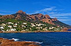
The '''Massif de l'Esterel''' (in Occitan [[Provençal dialect|Provençal]]: ''Esterèu''; English: ''Esterel Massif'') is a [[Mediterranean]] coastal mountain range in the departments of [[Var (department)|Var]] and [[Alpes-Maritimes]] in [[Provence]], south-east [[France]]. |
||
Neighbouring cities are [[Mandelieu]] and [[Cannes]] on the east, and [[Saint-Raphaël, Var|Saint-Raphaël]] and [[Fréjus]] on the west. |
Neighbouring cities are [[Mandelieu]] and [[Cannes]] on the east, and [[Saint-Raphaël, Var|Saint-Raphaël]] and [[Fréjus]] on the west. |
||
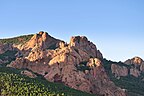
The soil and rocks of the range are of [[volcanic]] origin, composed mainly of [[porphyry (geology)|porphyry]], which gives the hills a red color. The [[terrain]] is rugged, with deep [[ravine]]s and oak forests. The highest point of the massif is [[ |
The soil and rocks of the range are of [[volcanic]] origin, composed mainly of [[porphyry (geology)|porphyry]], which gives the hills a red color. The [[terrain]] is rugged, with deep [[ravine]]s and oak forests. The highest point of the massif is [[Mont Vinaigre (Esterel)]] (614 metres). |
||
The massif covers an area of 320 km², of which 130 km² are officially protected in the Forêt domaniale de l'Esterel ([[National Forest (France)|National Forest]] of Esterel). The nature reserve offers hiking and mountain biking trails including the [[Grande Randonnée|GR]] 49 and GR 51. The Esterel mountains also host the [[Pierre & Vacances]] holiday village [[Cap Esterel]]. |
The massif covers an area of 320 km², of which 130 km² are officially protected in the Forêt domaniale de l'Esterel ([[National Forest (France)|National Forest]] of Esterel). The nature reserve offers hiking and mountain biking trails including the [[Grande Randonnée|GR]] 49 and GR 51. The Esterel mountains also host the [[Pierre & Vacances]] holiday village [[Cap Esterel]]. |
||
Revision as of 18:53, 23 December 2019
| Massif de l'Esterel | |
|---|---|
 | |
| Highest point | |
| Coordinates | 43° 30′ N, 6° 49′ E |
| Naming | |
| Language of name | French |
| Geography | |

| |
The Massif de l'Esterel (in Occitan Provençal: Esterèu; English: Esterel Massif) is a Mediterranean coastal mountain range in the departments of Var and Alpes-Maritimes in Provence, south-east France.
Neighbouring cities are Mandelieu and Cannes on the east, and Saint-Raphaël and Fréjus on the west.
The soil and rocks of the range are of volcanic origin, composed mainly of porphyry, which gives the hills a red color. The terrain is rugged, with deep ravines and oak forests. The highest point of the massif is Mont Vinaigre (Esterel) (614 metres).
The massif covers an area of 320 km², of which 130 km² are officially protected in the Forêt domaniale de l'Esterel (National Forest of Esterel). The nature reserve offers hiking and mountain biking trails including the GR 49 and GR 51. The Esterel mountains also host the Pierre & Vacances holiday village Cap Esterel.
The Corniche d'Or a scenic touristic road along the shore links Saint-Raphaël and Cannes.[1]
Gallery
-
 The Esterel Massif
 -
 Red cliffs of Esterel
 -
 Calanque d'Anthéor
 -
 Anthéor

.jpg)


References
- ^ "visiter la Corniche d'Or de l'Estérel". Estérel Côte d'Azur (in French). 2019-06-12. Retrieved 2019-08-19.
External links
43°30′N 6°49′E / 43.500°N 6.817°E
This Provence-Alpes-Côte d'Azur geography article is a stub. You can help Wikipedia by expanding it. |