
Waßmannsdorf
Waßmannsdorf | |
|---|---|
 Aerial view | |
 Coat of arms | |
Location of Waßmannsdorf  | |
 Waßmannsdorf  Waßmannsdorf | |
| Coordinates: 52°22′18″N 13°28′29″E / 52.37167°N 13.47472°E | |
| Country | Germany |
| State | Brandenburg |
| District | Dahme-Spreewald |
| Municipality | Schönefeld |
| Area | |
| • Total | 7.84 km2 (3.03 sq mi) |
| Elevation | 40 m (130 ft) |
| Population (2015) | |
| • Total | 784 |
| • Density | 100/km2 (260/sq mi) |
| Time zone | UTC+01:00 (CET) |
| • Summer (DST) | UTC+02:00 (CEST) |
| Postal codes | 12529 |
| Dialling codes | 03379 |
| Vehicle registration | LDS |
Waßmannsdorf is a village and a civil parish (Ortsteil) of the German town of Schönefeld, located in the district of Dahme-Spreewald in Brandenburg. As of 2007 its population was of around 1,000.
History
[edit]First mentioned in 1350 as Wasmanstorp, the village was an autonomous municipality until 2003, when it merged into Schönefeld.[1] From 1961 to 1989 its municipal borders with West Berlin were crossed by the Berlin Wall.
Geography
[edit]Waßmannsdorf is located in the southeastern suburb of Berlin, near the districts of Tempelhof-Schöneberg, Neukölln and Treptow-Köpenick; and bordering with the quarter of Rudow.[2] The nearest places are Großziethen, Selchow, Schönefeld and Blankenfelde-Mahlow. The village is 20 km far from Königs Wusterhausen, 28 from Ludwigsfelde and 34 from Potsdam.
Transport
[edit]Waßmannsdorf is situated close to the runway of the new Berlin Brandenburg Airport. Crossed by the Berlin outer ring, it is served by a new railway station[3] on the S-Bahn extension to the new airport[4][5] (lines S45 and S9).[6] The village is also interested by the Expressway Potsdam-Schönefeld projects.
Gallery
[edit]-
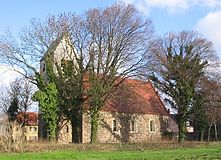 Village church
 -
 Former barracks


References
[edit]- ^ (in German) Historical chronicle of Waßmannsdorf
- ^ "Waßmannsdorf" (Map). Google Maps. Retrieved 23 September 2013.
- ^ Map at berliner-stadtplan.com
- ^ (in German) "Erster S-Bahn-Zug fuhr zum neuen Flughafenbahnhof" (article and images on S-Bahn Berlin website)
- ^ (in German) "Der Flughafen Berlin Brandenburg International" (article and map on S-Bahn Berlin website)
- ^ Map of the reorganization of the rail system serving the new airport "Berlin Brandenburg"
External links
[edit]- (in German) Waßmannsdorf page on Schönefeld municipal website
- (in German) Waßmannsdorf Fire Service
- (in German) SV Waßmannsdorf football club