
Bedford–Stuyvesant, Brooklyn
Bedford–Stuyvesant | |
|---|---|
 | |
| Nickname(s): Bed-Stuy, Do or Die | |
 Location in New York City | |
| Coordinates: 40°41′13″N 73°56′28″W / 40.687°N 73.941°W | |
| Country | |
| State | |
| City | |
| Borough | |
| Community District | Brooklyn 3,[1] Brooklyn 8[2] |
| Area | |
| • Total | 7.21 km2 (2.782 sq mi) |
| Population (2011)[3] | |
| • Total | 157,530 |
| • Density | 22,000/km2 (57,000/sq mi) |
| Ethnicity | |
| • Black | 49% |
| • White | 27% |
| • Hispanic | 19% |
| • Asian | 3% |
| • Others | 2% |
| Economics | |
| • Median income | $51,907 |
| Time zone | UTC−5 (Eastern) |
| • Summer (DST) | UTC−4 (EDT) |
| ZIP Codes | 11205, 11206, 11216, 11221, 11233, 11238 |
| Area code | 718, 347, 929, and 917 |
Bedford–Stuyvesant (/ˈbɛdfərdˈstaɪvəsənt/), colloquially known as Bed–Stuy,[5] is a neighborhood in the north-central portion of the New York City borough of Brooklyn. Bedford–Stuyvesant is bordered by Flushing Avenue to the north (bordering Williamsburg), Classon Avenue to the west (bordering Clinton Hill), Broadway to the east (bordering Bushwick and East New York), and Atlantic Avenue to the south (bordering Crown Heights and Brownsville).[6] The main shopping street, Fulton Street runs east–west the length of the neighborhood and intersects high-traffic north–south streets including Bedford Avenue, Nostrand Avenue, and Stuyvesant Avenue. Bedford–Stuyvesant contains four smaller neighborhoods: Bedford, Stuyvesant Heights, Ocean Hill, and Weeksville (also part of Crown Heights). Part of Clinton Hill was once considered part of Bedford–Stuyvesant.
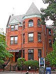
Bedford–Stuyvesant has the largest collection of intact and largely untouched Victorian architecture in the country, with roughly 8,800 buildings built before 1900.[7] Its building stock includes many historic brownstones. These homes were developed for the expanding upper-middle class from the 1890s to the late 1910s. These homes contain highly ornamental detailing throughout their interiors and have classical architectural elements, such as brackets, quoins, fluting, finials, and elaborate frieze and cornice banding.
Since the late 1930s the neighborhood has been a major cultural center for Brooklyn's African American population. Following the construction of the Fulton Street subway line (A and C trains)[8] in 1936, African Americans left an overcrowded Harlem for greater housing availability in Bedford–Stuyvesant. From Bedford–Stuyvesant, African Americans have since moved into the surrounding areas of Brooklyn, such as East New York, Crown Heights, Brownsville, and Fort Greene.
Bedford–Stuyvesant is mostly part of Brooklyn Community District 3, though a small part is also in Community District 8. Its primary ZIP Codes are 11205, 11206, 11216, 11221, 11233, and 11238.[1][2] Bedford–Stuyvesant is patrolled by the 79th and 81st Precincts of the New York City Police Department.[9][10] Politically it is represented by the New York City Council's 36th District.
History
Founding
The neighborhood's name combines the names of the Village of Bedford and the Stuyvesant Heights neighborhoods. Stuyvesant is derived from Peter Stuyvesant, the last governor of the colony of New Netherland.
17th and 18th centuries
In the second half of the 17th century, the lands which constitute the present neighborhood belonged to three Dutch settlers: Dirck Janse Hooghland, who operated a ferryboat on the East River, and farmers Jan Hansen, and Leffert Pietersen van Haughwout. In pre-revolutionary Kings County, Bedford was the first, major settlement east of the Village of Brooklyn on the ferry road to the town of Jamaica and eastern Long Island. Stuyvesant Heights, however, was farmland; the area became a community after the American Revolutionary War.
For most of its early history, Stuyvesant Heights was part of the outlying farm area of the small hamlet of Bedford, settled by the Dutch during the 17th century within the incorporated town of Breuckelen. The hamlet had its beginnings when a group of Breuckelen residents decided to improve their farm properties behind the Wallabout section, which gradually developed into an important produce center and market. The petition to form a new hamlet was approved by Governor Stuyvesant in 1663. Its leading signer was Thomas Lambertsen, a carpenter from Holland. A year later, the British capture of New Netherland signaled the end of Dutch rule. In Governor Nicolls' Charter of 1667 and in the Charter of 1686, Bedford is mentioned as a settlement within the Town of Brueckelen. Bedford hamlet had an inn as early as 1668, and, in 1670, the people of Breuckelen purchased from the Canarsie Indians an additional area for common lands in the surrounding region.
Bedford Corners, approximately located where the present Bedford Avenue meets Fulton Street, and only three blocks west of the present Historic District, was the intersection of several well traveled roads. The Brooklyn and Jamaica Turnpike, constructed by a corporation founded in 1809 and one of the oldest roads in Kings County, ran parallel to the present Fulton Street, from the East River ferry to the village of Brooklyn, thence to the hamlet of Bedford and on toward Jamaica via Bed–Stuy. Farmers from New Lots and Flatbush used this road on their way to Manhattan. Within the Stuyvesant Heights Historic District, the Turnpike ran along the approximate line of Decatur Street. Cripplebush Road to Newtown and the Clove Road to Flatbush also met at Bedford Corners. Hunterfly Road, which joined the Turnpike about a mile to the east of Clove Road, also served as a route for farmers and fishermen of the Canarsie and New Lots areas.
At the time of the Revolution, Leffert's son Jakop was a leading citizen of Bedford and the town clerk of Brooklyn. His neighbor, Lambert Suydam, was captain of the Kings County cavalry in 1776. An important part of the Battle of Long Island took place in and near the Historic District. In 1784, the people of the Town of Brooklyn held their first town meeting since 1776.
19th century

In 1800, Bedford was designated one of the seven districts of the Town of Brooklyn, and, in 1834, it became part of the seventh and ninth wards of the newly incorporated City of Brooklyn. With the building of the Brooklyn and Jamaica Railroad in 1833, along Atlantic Avenue, Bedford was established as a railroad station near the intersection of current Atlantic Avenue and Franklin Avenues. In 1836, the Brooklyn and Jamaica Railroad was taken over by the Long Island Rail Road (LIRR), which in 1878 would gain a connection to the Brooklyn, Flatbush and Coney Island Railway's northern terminal.[11] The Weeksville subsection, founded in 1838, was recognized as one of the first, free African-American communities in the United States.[12]
The present street grid was laid out in 1835, as shown by the Street Commissioners map of 1839, and the blocks were divided into lots The new street grid led to the abandonment of the Brooklyn and Jamaica Turnpike in favor of a continuation of Brooklyn's Fulton Street, though the lands for the street grid were not sold to the City of Brooklyn until 1852. When Charles C. Betts purchased Maria Lott's tract of land the same year, this marked the end of two centuries of Dutch patrimonial holdings. Most of the streets were not opened until the 1860s, at which point Bedford–Stuyvesant's streets were named after prominent figures in American history. The Dripps Map of 1869 shows that the area was still largely rural with a few freestanding houses mostly on MacDonough Street. The real development of the district began slowly at first, accelerating between 1885 and 1900, and gradually tapering off during the first two decades of the 20th century.

Construction of masonry row houses in the 1870s began to transform the rural district into an urban area. The first row of masonry houses in Stuyvesant Heights was built in 1872 on MacDonough Street for developer Curtis L. North. In the 1880s and 1890s, more rows were added, most of the Stuyvesant Heights north of Decatur Street looked much as it does today. Stuyvesant Heights was emerging as a neighborhood entity with its own distinctive characteristics. The houses had large rooms, high ceilings and large windows, and were built primarily by German immigrants.[13] The people who bought these houses were generally upper-middle-class families, mostly lawyers, shopkeepers, and merchants of German and Irish descent, with a sprinkling of English people; there were also a few professionals. A contemporary description calls it a very well kept residential neighborhood, typical of the general description of Brooklyn as "a town of homes and churches."
Built in 1863, the Capitoline Grounds were the home of the Brooklyn Atlantics baseball team.[14] The grounds were bordered by Nostrand Avenue, Halsey Street, Marcy Avenue, and Putnam Avenue.[14] During the winters, the operators would flood the area and open an ice-skating arena. The grounds were demolished in 1880.[citation needed]

In 1890, the city of Brooklyn founded another subsection Ocean Hill, a working-class predominantly Italian enclave. In the last decades of the 19th century, with the advent of electric trolleys and the Fulton Street Elevated, Bedford–Stuyvesant became a working-class and middle-class bedroom community for those working in downtown Brooklyn and Manhattan in New York City. At that time, most of the pre-existing wooden homes were destroyed and replaced with brownstone rowhouses.
20th century
1900s to 1950s
In 1907, the completion of the Williamsburg Bridge facilitated the immigration of Jews and Italians from the Lower East Side of Manhattan.[15]
During the 1930s, major changes took place due to the Great Depression years. Immigrants from the American South and the Caribbean brought the neighborhood's black population to around 30,000, making it the second largest Black community in the city at the time. During World War II, the Brooklyn Navy Yard attracted many black New Yorkers to the neighborhood as an opportunity for employment, while the relatively prosperous war economy enabled many of the Jewish and Italian residents to move to Queens and Long Island. By 1950, the number of black residents had risen to 155,000, comprising about 55 percent of the population of Bedford–Stuyvesant.[15] In the 1950s, real estate agents and speculators employed blockbusting to turn a profit. As a result, formerly middle-class white homes were being turned over to poorer black families. By 1960, eighty-five percent of the population was black.[15]
1960s

Gang wars erupted in 1961 in Bedford–Stuyvesant, and Alfred E. Clark of The New York Times referred to it as "Brooklyn's Little Harlem."[16] One of the first urban riots of the era took place there due to social and racial divisions in the city contributed to the tensions. Race riots between the NYPD and the city's black community were strained due to perceptions of the NYPD as being oppressive and racially biased, and at that time, few black policemen were present on the force.[17] Predominantly black neighborhoods received disproportionate rates of arrests and prosecutions for drug-related crimes, and the NYPD's 79th Precinct in Bedford–Stuyvesant was one of the only three police precincts in the NYPD where black police officers were allowed to patrol.[18] Race riots followed in 1967 and 1968, as part of the political and racial tensions in the United States of the era, aggravated by continued high unemployment among blacks, continued de facto segregation in housing, and the failure to enforce civil rights laws.

With the help of local activists and politicians, such as Civil Court Judge Thomas Jones, grassroots organizations of community members and businesses willing to aid were formed and began the rebuilding of Bedford–Stuyvesant. In 1965, Andrew W. Cooper, a journalist from Bedford–Stuyvesant, brought suit under the Voting Rights Act against racial gerrymandering[19] under the grounds that Bedford–Stuyvesant was divided among five congressional districts, each with a white representative.[20] It resulted in the creation of New York's 12th Congressional District and the election in 1968 of Shirley Chisholm, the first black woman and West Indian American ever elected to the US Congress.[21]
In 1967, Robert F. Kennedy, U.S. senator for New York state, launched a study of problems facing the urban poor in Bedford–Stuyvesant, which received almost no federal aid and was the city's largest non-white community.[22][23] Under Kennedy's leadership and with the help of activists, the Bedford Stuyvesant Restoration Corporation was established as the United States’ first community development corporation.[24] The Manhattan-based Development and Services Corporation (D&S) was established with business, banking and professional leaders which advised and raised private funding for the BSRC's projects.[24] The abandoned Sheffield Milk bottling plant on Fulton Street was turned into the BSRC offices in 1967,[24] and the BSRC bought and renovated many housing units as well as administered a $73 million mortgage assistance program to encourage African-American homeownership.[24] The BSRC also implemented a controversial plan by I.M. Pei to close off St. Marks Avenue and Prospect Place, between Kingston and Albany Avenues, and convert these into community spaces.[24]
1970s and 1980s

In the late 1980s, resistance to illegal drug-dealing included, according to Rita Webb Smith, following police arrests with a civilian Sunni Muslim 40-day patrol of several blocks near a mosque, the same group having earlier evicted drug sellers at a landlord's request, although that also resulted in arrests of the Muslims for "burglary, menacing and possession of weapons", resulting in a probationary sentence.[25]: 290
Recent history
2000s
Beginning in the 2000s, the neighborhood began to experience gentrification.[8] The two significant reasons for this were the affordable housing stock consisting of brownstone rowhouses located on quiet tree-lined streets, as well as the marked decrease of crime in the neighborhood. Many properties were renovated after the start of the 21st century, and new retailers began moving to the neighborhood. There was a belief that neighborhood change would benefit all residents of the area, bringing with it greater neighborhood safety, more local jobs, and retail demand on major commercial strips. As such, both the Fulton Street and Nostrand Avenue commercial corridors became part of the Bed-Stuy Gateway Business Improvement District, bringing along with it a beautification project.[26] Through a series of "wallscapes" (large outdoor murals), the campaign honored famous community members, including community activist and poet June Jordan, activist Hattie Carthan, and rapper The Notorious B.I.G.[27] The campaign sought to show off the area's positive accomplishments.[28]
Several long-time residents and business owners expressed concern that they would be priced out by newcomers, whom they disparagingly characterize as "yuppies and buppies [black urban professionals]", according to one neighborhood blog.[29] They feared that the neighborhood's ethnic character would be lost. However, Bedford–Stuyvesant's population has experienced much less displacement of the black population than other areas of Brooklyn, such as Williamsburg and Cobble Hill.[30] Bedford–Stuyvesant saw the influx of more upwardly mobile middle class African American families, as well as immigrants from Africa and the Caribbean. Surrounding neighborhoods in northern and eastern Brooklyn have a combined population of about 940,000 and are roughly 82% black, making them the largest concentration of African Americans in the United States.[31]
In July 2005, the NYPD designated the Fulton Street–Nostrand Avenue business district in Bedford–Stuyvesant as an "Impact Zone", which directed significantly increased levels of police protection and resources to the area for two consecutive 6-month periods, resulting in a 15% decrease in crime within one year. Despite the improvements and increasing stability of the community, Bedford–Stuyvesant has continued to be stigmatized in some circles. In March 2005 a campaign was launched to supplant the "Bed-Stuy, Do-or-Die" slogan with "Bed-Stuy, and Proud of It".[32] Violent crime also remains a problem in the area, and the two precincts that cover Bedford–Stuyvesant reported a combined 37 murders in 2010.[33][34]

2010s
Despite the largest recession to hit the United States in the last 70 years, gentrification continued steadily, and the blocks north of the Nostrand Avenue/Fulton Street intersection and west of Fulton Street and Stuyvesant Avenue were particularly impacted. In 2011, Bedford–Stuyvesant listed three Zagat-rated restaurants for the first time. Today there are over ten Zagat-rated establishments,[35] and in June 2013, 7 Arlington Place, the setting for Spike Lee's 1994 film Crooklyn, was sold for over its asking price, at $1.7 million.[36]
A diverse mix of students, hipsters, artists, creative professionals, architects, and attorneys of all races continue to move to the neighborhood. A business improvement district has been launched along the Fulton and Nostrand Corridor with a redesigned streetscape to include new street trees, street furniture, pavers, and signage and improved cleanliness in an effort to attract more business investment.[37] Major infrastructure upgrades have been performed or are in progress, such as Select Bus Service bus rapid transit on the B44 route along Nostrand and Bedford Avenues, which began operating in late 2013.[38] Other infrastructure upgrades in the neighborhood includes major sewer and water modernization projects,[39] as well as fiber-optic and cable service upgrades.[40] Improved natural and organic produce continue to become available at local delis and grocers, the farmer's market on Malcolm X Boulevard, and through the Bed-Stuy Farm Share.[41] FreshDirect services the neighborhood, and a large member constituency of the adjacent Greene-Hill Food Coop are from Bedford–Stuyvesant.
Subsections
Neighborhoods
Bedford is located toward the western end of Bedford-Stuyvesant. Before the American Revolutionary War times, it was the first settlement to the east of the Village of Brooklyn. It was originally part of the old village of Bedford, which was centered near today's Bedford Avenue–Fulton Street intersection. The area "extends from Monroe Street on the north to Macon Street and Verona Place on the south, and from just east of Bedford Avenue eastward to Tompkins Avenue," according to the Landmarks Preservation Commission.[42][43] Bedford is adjacent to Williamsburg, Crown Heights, and Clinton Hill.[44]
Stuyvesant Heights is located toward the southern-central section of Bedford-Stuyvesant. It has historically been an African-American enclave. It derives its name from Stuyvesant Avenue, its principal thoroughfare. It was originally part of the outlying farm area of Bedford for most of its early history. A low-rise residential district of three- and four-story masonry row houses and apartment buildings with commercial ground floors, it was developed mostly between 1870 and 1920,[44][45][46] mainly between 1895 and 1900.[47] The Stuyvesant Heights Historic District is located within the area bounded roughly by Tompkins Avenue on the west, Macon and Halsey Streets on the north, Malcolm X Boulevard on the east, and Fulton Street on the south.[47][48]
Ocean Hill is located toward the eastern end Ocean Hill received its name in 1890 for being slightly hilly. Hence it was subdivided from the larger community of Stuyvesant Heights. From the beginning of the 20th century to the 1960s Ocean Hill was an Italian enclave. By the late 1960s Ocean Hill and Bedford-Stuyvesant proper together formed the largest African American community in the United States.
Weeksville is located toward the southeast. Weeksville was named after an ex-slave[49] from Virginia, who in 1838[50] bought a plot of land and founded Weeksville.
Historic district
Stuyvesant Heights Historic District | |
 On Decatur Street | |
 | |
| Location | Roughly bounded by Macon, Tompkins, Decatur, Lewis, Chauncey, and Stuyvesant, New York, New York |
|---|---|
| Coordinates | 40°40′52″N 73°56′14″W / 40.68111°N 73.93722°W |
| Area | 42 acres (17 ha) |
| Built | 1870 |
| Architectural style | Italianate, Queen Anne, Romanesque |
| NRHP reference No. | 75001193[51] |
Stuyvesant Heights Historic District (Boundary Increase) | |
| Location | Roughly, Decatur St. from Tompkins to Lewis Aves., Brooklyn, New York |
| Area | 10 acres (4.0 ha) |
| Architect | multiple |
| Architectural style | Italianate, Second Empire, Queen Anne |
| NRHP reference No. | 96001355[51] |
| Added to NRHP | November 15, 1996 |
| Added to NRHP | December 4, 1975 |
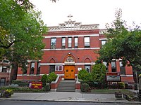
The Stuyvesant Heights Historic District in Bedford-Stuyvesant comprises 577 contributing residential buildings built between about 1870 and 1900. The district encompasses 17 individual blocks (13 identified in 1975 and four new in 1996). The buildings within the district primarily comprise two- and three-storey rowhouses with high basements, with a few multiple dwellings and institutional structures. The district includes the Our Lady of Victory Catholic Church, the Romanesque Revival style Mount Lebanon Baptist Church, and St. Phillip's Episcopal Church.[52][53] It was listed on the National Register of Historic Places in 1975 and expanded in 1996.[51] Bedford Stuyvesant/Expanded Stuyvesant Heights Historic District was designated on April 16, 2013 and extended the district north to Jefferson Ave, east to Malcolm X Blvd, and west to Tompkins Avenue.[47]
-
 Miracle Temple
 -
 On Decatur Street
 -
 On Decatur Street
 -
 St. Phillip's Episcopal Church
 -
 Mt. Lebanon Baptist Church
 -
 Mt. Lebanon Baptist Church
 -
 On Lewis Street


Demographics
The entirety of Community Board 3 had 152,403 inhabitants as of NYC Health's 2018 Community Health Profile, with an average life expectancy of 76.8 years.[54]: 2, 20 This is lower than the median life expectancy of 81.2 for all New York City neighborhoods.[55]: 53 (PDF p. 84) [56] Most inhabitants are middle-aged adults and youth: 24% are between the ages of 0–17, 33% between 25–44, and 22% between 45–64. The ratio of college-aged and elderly residents was lower, at 10% and 11% respectively.[54]: 2
As of 2016, the median household income in Community Board 3 was $51,907.[4] In 2018, an estimated 23% of Bedford–Stuyvesant residents lived in poverty, compared to 21% in all of Brooklyn and 20% in all of New York City. One in eight residents (13%) were unemployed, compared to 9% in the rest of both Brooklyn and New York City. Rent burden, or the percentage of residents who have difficulty paying their rent, is 53% in Bedford–Stuyvesant, higher than the citywide and boroughwide rates of 52% and 51% respectively. Based on this calculation, as of 2018[update], Bedford–Stuyvesant is considered to be gentrifying.[54]: 7
Demographic trends
The 1790 census records of Bedford lists 132 freemen and 72 slaves. Rapid population growth followed major improvements to public transportation. By 1873, Bed-Stuy's (predominantly white) population was 14,000.[57] In the early 1900s, prosperous black families began buying up the mansions of Bed-Stuy, many of which were designed by prominent architects.[58] The population was quick to grow, but it wasn't until the 1930s that Bed-Stuy's black population boomed. Following the introduction of the IND Fulton Street Line (a.k.a. the A/C line) in 1936, African-Americans left crowded Harlem in search of better housing opportunities. Bed-Stuy quickly became the second destination for black New Yorkers and the New York Times even dubbed it “Little Harlem” in 1961.
After a large decline during the 1970s (mirroring the citywide decline), the population in Bedford Stuyvesant grew by 34 percent between 1980 and 2015 (faster than the citywide growth rate of 21 percent) to reach 150,900 residents. The population has increased by 25 percent in just the past 15 years, more than three times faster than the citywide rate. The ethnic and racial mix of the population has undergone dramatic changes in the past 15 years as the neighborhood has attracted new residents. According to data from the U.S. Census Bureau, three-quarters of the residents identified as black or African-American in 2000, but this share had declined to less than half of the population by 2015. In 2015 (the latest year for which census data are available), one-quarter of the residents were white and nearly one-fifth were Hispanic. By comparison, in 2000, less than 3 percent of the population was white (the Hispanic share of the population has remained relatively unchanged). The Asian population has grown, but remains relatively small, making up less than 3 percent of the neighborhood[59] According to the US Census Bureau, in 2016 the population was 49% Black, 27% White, 19% Hispanic, 3% Asian, and 2% other or from two or more races.[4]
Politics
The neighborhood is part of New York's 8th congressional district,[60][61] represented by Democrat Hakeem Jeffries as of 2013[update].[62] It is also part of the 18th and 25th State Senate districts,[63][64] represented respectively by Democrats Julia Salazar and Velmanette Montgomery,[65][66] and the 54th, 55th, and 56th State Assembly districts,[67][68] represented respectively by Democrats Erik Dilan, Latrice Walker, and Tremaine Wright.[69] Bed-Stuy is located in the New York City Council's 36th and 41st districts,[70] represented respectively by Democrats Robert Cornegy and Alicka Ampry-Samuel.[71][72]
Police and crime
Bedford–Stuyvesant is patrolled by two precincts of the NYPD.[73] The 81st Precinct is located at 30 Ralph Avenue, serving the area east of Marcus Garvey Boulevard,[10] and the 79th Precinct is located at 263 Tompkins Avenue, serving the area west of Marcus Garvey Boulevard.[9]
The area collectively covered by the 79th and 81st Precincts ranked 62nd safest out of 69 patrol areas for per-capita crime in 2010. While total crime has decreased since the 1990s, it is still higher in Bed-Stuy than in much of the rest of the city.[74] However, in 2016, major crime dropped 11 percent in the 81st Precinct, marking the greatest reduction in north Brooklyn's 10 precincts.[75] As of 2018[update], with a non-fatal assault rate of 117 per 100,000 people, Bedford–Stuyvesant's rate of violent crimes per capita is greater than that of the city as a whole. The incarceration rate of 1,045 per 100,000 people is higher than that of the city as a whole.[54]: 8
The 79th Precinct has a lower crime rate than in the 1990s, with crimes across all categories having decreased by 78.8% between 1990 and 2018. The precinct reported 9 murders, 27 rapes, 309 robberies, 343 felony assaults, 301 burglaries, 484 grand larcenies, and 72 grand larcenies auto in 2018.[76] The 81st Precinct had a relatively smaller crime decrease of 73.9% between 1990 and 2018. The precinct reported 10 murders, 25 rapes, 234 robberies, 274 felony assaults, 218 burglaries, 399 grand larcenies, and 48 grand larcenies auto in 2018.[77]
Fire safety
The New York City Fire Department (FDNY) operates seven fire stations in Bedford–Stuyvesant:[78][79]
- Ladder Company 102 – 850 Bedford Avenue
- Engine Company 230 – 701 Park Avenue[80]
- Battalion 57/Engine Company 235 – 206 Monroe Street[81]
- Engine Company 217 – 940 DeKalb Avenue[82]
- Engine Company 214/Ladder Company 111 – 495 Hancock Street[83]
- Battalion 37/Engine Company 222 – 32 Ralph Avenue[84]
- Engine Company 233/Ladder Company 176/Field Comm Unit 1 – 25 Rockaway Avenue[85]
Health
As of 2018[update], preterm births and births to teenage mothers are more common in Bedford–Stuyvesant than in other places citywide. In Bedford–Stuyvesant, there were 95 preterm births per 1,000 live births (compared to 87 per 1,000 citywide), and 26.9 births to teenage mothers per 1,000 live births (compared to 19.3 per 1,000 citywide).[54]: 11 Bedford–Stuyvesant has a relatively low population of residents who are uninsured, or who receive healthcare through Medicaid.[86] In 2018, this population of uninsured residents was estimated to be 11%, which is slightly lower than the citywide rate of 12%.[54]: 14
The concentration of fine particulate matter, the deadliest type of air pollutant, in Bedford–Stuyvesant is 0.0081 milligrams per cubic metre (8.1×10⁻⁹ oz/cu ft), higher than the citywide and boroughwide averages.[54]: 9 Nineteen percent of Bedford–Stuyvesant residents are smokers, which is higher than the city average of 14% of residents being smokers.[54]: 13 In Bedford–Stuyvesant, 29% of residents are obese, 13% are diabetic, and 34% have high blood pressure—compared to the citywide averages of 24%, 11%, and 28% respectively.[54]: 16 In addition, 22% of children are obese, compared to the citywide average of 20%.[54]: 12
Eighty-four percent of residents eat some fruits and vegetables every day, which is slightly lower than the city's average of 87%. In 2018, 76% of residents described their health as "good," "very good," or "excellent," slightly less than the city's average of 78%.[54]: 13 For every supermarket in Bedford–Stuyvesant, there are 57 bodegas.[54]: 10
There are several hospitals in the Bed-Stuy area, including the Woodhull Medical Center and the Interfaith Medical Center.[86]: 19–20
Post offices and ZIP Codes
Bedford–Stuyvesant is covered by four primary ZIP Codes (11206, 11216, 11221, 11223) and parts of three other ZIP Codes (11205, 11213, and 11233). The northern part of the neighborhood is covered by 11206; the central part, by 11221; the southwestern part, by 11216; and the southeastern part, by 11223. In addition, the ZIP Code 11205 covers several blocks in the northwestern corner of Bed-Stuy, and 11213 includes several blocks in the extreme southern portion of the neighborhood.[87] The United States Postal Service operates four post offices nearby: the Restoration Plaza Station at 1360 Fulton Street,[88] the Shirley A Chisholm Station at 1915 Fulton Street,[89] the Bushwick Station at 1369 Broadway,[90] and the Halsey Station at 805 MacDonough Street.[91]
Education
Bedford–Stuyvesant generally has a lower ratio of college-educated residents than the rest of the city as of 2018[update]. While 35% of residents age 25 and older have a college education or higher, 21% have less than a high school education and 43% are high school graduates or have some college education. By contrast, 40% of Brooklynites and 38% of city residents have a college education or higher.[54]: 6 The percentage of Bedford–Stuyvesant students excelling in reading and math has been increasing, with reading achievement rising from 32 percent in 2000 to 37 percent in 2011, and math achievement rising from 23 percent to 47 percent within the same time period.[92]
Bedford–Stuyvesant's rate of elementary school student absenteeism is higher than the rest of New York City. In Bedford–Stuyvesant, 30% of elementary school students missed twenty or more days per school year, compared to the citywide average of 20% of students.[55]: 24 (PDF p. 55) [54]: 6 Additionally, 70% of high school students in Bedford–Stuyvesant graduate on time, lower than the citywide average of 75% of students.[54]: 6
Schools

Several public schools serve Bedford-Stuyvesant. The zoned high school for the neighborhood is Boys and Girls High School on Fulton Street. The Brooklyn Brownstone School, a public elementary school located in the MS 35 campus on MacDonough Street, and was developed in 2008 by the Stuyvesant Heights Parents Association and the New York City Board of Education. At the eastern edge of the neighborhood is Paul Robeson High School for Business and Technology.
Many public schools are named after prominent African-Americans and, as stated by Nikole Hannah-Jones in The New York Times, were "intended to evoke black uplift".[93] Hannah-Jones wrote in 2016 that many wealthier residents choose to use magnet schools or private schools instead of neighborhood schools.[93]
For the early grades Ember Charter School for Mindful Education and Success Academy Bed-Stuy 1 and 2 are charter schools. Bed-Stuy is also home to the Brooklyn Waldorf School, which moved to Claver Castle (at 11 Jefferson Avenue) in 2011.
Other institutions include:
- Boys High School
- Girl's High School
- Pratt Institute
- Brooklyn Brownstone Elementary School
- Weeksville Heritage Center
- Bedford Academy High School
Libraries
The Brooklyn Public Library (BPL) has four branches in Bedford-Stuyvesant:
- The Bedford branch and Bedford Learning Center, at 496 Franklin Avenue near Fulton Street. The branch opened in 1905.[94]
- The Marcy branch, at 617 DeKalb Avenue near Nostrand Avenue.[95]
- The Macon branch, at 361 Lewis Avenue near Macon Street. The branch is a Carnegie library that opened in 1907. It contains the Dionne Mack-Harvin Center, a collection dedicated to African American culture.[96]
- The Saratoga branch, at 8 Thomas S. Boyland Street near Macon Street. The branch is a Carnegie library that opened in 1909.[97]
Transportation

.jpg)
Bedford–Stuyvesant is served by the New York City Subway's IND Fulton Street Line (A and C trains), which opened in 1936. This underground line replaced the earlier, elevated BMT Fulton Street Line on May 31, 1940. The IND Crosstown Line (G train), running underneath Lafayette Avenue and Marcy Avenue, opened for service in 1937. The elevated BMT Jamaica Line (J, M, and Z trains) also serves the neighborhood, running alongside its northern boundary at Broadway. Additionally, the elevated BMT Lexington Avenue Line served Lexington Avenue until 1950 and the elevated BMT Myrtle Avenue Line served Myrtle Avenue to the north until 1969.
Bedford–Stuyvesant is also served by the Nostrand Avenue station of the Long Island Rail Road.
Several bus routes, operated by MTA Regional Bus Operations, run through Bedford–Stuyvesant. The B7, B15, B43, B44, B44 SBS, B46, B46 SBS, B47, B48 and B60 routes run primarily north to south through the neighborhood, while the B25, B26, B38, B52 and B54 run primarily west to east, and the Q24, B46, and B47 run northwest to southeast on Broadway.[98]
Notable people
- Aaliyah (1979–2001), Grammy-nominated singer.[99]
- Aja (born 1994), drag queen and performer
- Big Daddy Kane (born 1968), rapper.[100]
- Memphis Bleek (born 1978), rapper.[101]
- Mark Breland (born 1963), boxer.[102]
- Foxy Brown (born 1978), rapper[citation needed]
- Lil Cease (born 1977), rapper[103]
- Shirley Chisholm (1924–2005), congresswoman[104]
- Imani Coppola (born 1978), singer-songwriter[105]
- Alan Dale (1925–2002), singer and star of The Alan Dale Show[106]
- Deemi (born 1980), singer[107]
- Desiigner (born 1997), rapper[108]
- Nelson Erazo (born 1977), professional wrestler better known by his ring name Homicide[citation needed]
- Fabolous (born 1977), rapper[109]
- Bobby Fischer (1943–2008), eleventh World Chess Champion[citation needed]
- William Forsythe (born 1955), actor
- Jackie Gleason (1916–87), actor, comedian[110]
- Carl Gordon (1932–2010), actor[111]
- Kadeem Hardison (born 1965), actor, portrays Dwayne Wayne on A Different World[112]
- Richie Havens (1941–2013), musician and poet[113]
- Connie Hawkins (1942-2017), Basketball Hall of Fame player[114]
- Lena Horne (1917–2010), actress and singer[115]
- Jay-Z (born 1969), rapper and entrepreneur, who lived in the Marcy Housing Projects for most of his childhood[116]
- Jaz-O (born 1964), rapper[citation needed]
- Joey Badass (born 1995), rapper[117]
- Norah Jones (born 1979), singer[118]
- June Jordan (1936–2002), Caribbean American poet, novelist, journalist, biographer, dramatist, teacher and activist[119]
- Wee Willie Keeler (1872–1923), Baseball Hall-of-Famer[120]
- Brian Kokoska (born 1988), artist[citation needed]
- Talib Kweli (born 1975), emcee[citation needed]
- Lil' Kim (born 1974), rapper[121]
- Maino (born 1973), rapper[122]
- Masta Ace (born 1966), rapper[citation needed]
- Frank McCourt (1930–2009), a writer, and Malachy McCourt (born 1931), an actor, writer and politician. Frank's autobiographical bestseller Angela's Ashes describes their early childhood life in a working-class apartment building on Classon Avenue.[123]
- Frank Mickens (1946–2009), educator[124]
- Stephanie Mills (born 1957), singer
- Sauce Money, rapper
- Tracy Morgan (born 1968), comedian and actor[125]
- Mos Def (aka Yasiin Bey) (born 1973), rapper
- Ali Shaheed Muhammad (born 1970), DJ, producer and member of A Tribe Called Quest[126]
- Jack Newfield (1938–2004), journalist[15]
- Harry Nilsson (1941-1994), musician, songwriter and author[127]
- The Notorious B.I.G. (1972–97), rapper, grew up near the Clinton Hill-Bed Stuy border, previously considered part of the Bedford-Stuyvesant neighborhood.[128][129]
- Oddisee, rapper, producer
- Ol' Dirty Bastard (1968–2004), rapper
- Papoose (born 1978), rapper
- Floyd Patterson (1935–2006), boxer
- Martha M. Place (1849–99), first woman to be put to death in the electric chair[130]
- Jackie Robinson (1919–72), professional baseball player with the Brooklyn Dodgers[131]
- Chris Rock (born 1965), actor/comedian.[132] Also made a TV series about his early life, with much of it based in Bedford-Stuyvesant.
- Tony Rock (born 1974), comedian and younger brother of Chris Rock
- Gabourey Sidibe (born 1983), Academy Award-nominated actress
- Skyzoo (born 1982), rapper
- Brandon Stanton (born 1984), Humans of New York author and photographer
- Tek (born 1973), one half of Smif-N-Wessun
- Bill Thompson (born 1953), New York City 2013 Mayoral candidate[133]
- TRUE (born 1968), artist
- Mike Tyson (born 1966), boxer, lived there with his family until the age of 10.[134]
- Martha Wainwright (born 1976), singer
- Dan Washburn, author of The Forbidden Game: Golf and the Chinese Dream
- Whodini, hip-hop group
- Lenny Wilkens (born 1937), Basketball Hall of Fame player and coach[135]
- Juan Williams (born 1954), journalist and political analyst
- Ted Williams (born 1957), voiceover artist
- Vanessa A. Williams (born 1963), actress
In popular culture
- Billy Joel's 1980 song "You May Be Right," from his album Glass Houses, includes "I walked through Bedford-Stuy alone" among the foolhardy things the song's narrator has done.[136]
- In her 1980 one-woman film Gilda Live, Gilda Radner included a sketch featuring her Emily Litella character working as a substitute teacher in Bedford-Stuyversant, filling in for a teacher who'd been stabbed by one of his students.[137]
- Do the Right Thing, a movie by Spike Lee, takes place in Bed–Stuy.[25]: 290
- Notorious B.I.G., a rapper who included Bed–Stuy in his lyrics,[128] he "publicly claim[ed] Bedford-Stuyvesant as his neighborhood".[138] A 2009 film, Notorious, about life in Bed–Stuy in the 1990s, emphasized Notorious B.I.G.[139]
- The period television sitcom, Everybody Hates Chris is set in the Bed-Stuy neighborhood (which is where series creator Chris Rock’s family lived in during the 1970s and 1980s).[140] The show occasionally refers to the neighborhood by its often-used nickname "Bed-Stuy Do or Die."
See also
- 13th Regiment Armory, former armory in Bed–Stuy
- Magnolia grandiflora (Brooklyn), a landmark tree in Bed–Stuy
References
- ^ a b "NYC Planning | Community Profiles". communityprofiles.planning.nyc.gov. New York City Department of City Planning. Retrieved March 18, 2019.
- ^ a b "NYC Planning | Community Profiles". communityprofiles.planning.nyc.gov. New York City Department of City Planning. Retrieved March 18, 2019.
- ^ a b https://censusreporter.org/profiles/79500US3604003-nyc-brooklyn-community-district-3-bedford-stuyvesant-puma-ny. Retrieved August 8, 2019.
{{cite web}}: Missing or empty|title=(help) - ^ a b c "Census profile: NYC-Brooklyn Community District 3--Bedford-Stuyvesant PUMA, NY". Retrieved July 17, 2018.
- ^ Woodsworth, Michael (May 6, 2016). Battle for Bed-Stuy: The Long War on Poverty in New York City (illustrated ed.). Harvard University Press. ISBN 9780674545069.
- ^ "Brooklyn Community District 3" Archived May 14, 2008, at the Wayback Machine (pdf). New York City Department of City Planning. December 2007. Accessed April 25, 2008.
- ^ Gregor, Alison (July 9, 2014). "Bedford-Stuyvesant: Diverse and Changing". The New York Times. ISSN 0362-4331. Retrieved July 16, 2019.
- ^ a b Echanove, Matias. "Bed-Stuy on the Move" Archived September 16, 2017, at the Wayback Machine. Master thesis. Urban Planning Program. Columbia University. Urbanology.org. 2003.
- ^ a b "NYPD – 79th Precinct". www.nyc.gov. Retrieved October 3, 2016.
- ^ a b "NYPD – 81st Precinct". www.nyc.gov. Retrieved October 3, 2016.
- ^ "The Brooklyn, Flatbush and Coney Island Railroad (The Brighton Line)/The New York and Manhattan Beach Railroad". nycsubway.org. Retrieved January 16, 2013.
- ^ Ramirez, Anthony."Haven for Blacks in Civil War Riots Now Safeguards History", The New York Times, June 5, 2005. Accessed November 17, 2007.
- ^ Gregor, Alison (July 13, 2014). "Bedford-Stuyvesant: Diverse and Changing". The New York Times. Retrieved September 18, 2018.
- ^ a b Ross, Andrew; David Dyte. "Capitoline Grounds". covehurst.net. Retrieved October 31, 2008.
- ^ a b c d Newfield, Jack (1988). Robert Kennedy: A Memoir (reprint ed.). New York: Penguin Group. pp. 87–109. ISBN 0-452-26064-7.
- ^ Clark, Alfred E. "GANG WARS UPSET AREA IN BROOKLYN; Bedford – Stuyvesant Tense Following Two Slayings." The New York Times. Tuesday May 2, 1961. Page 31. Retrieved on January 22, 2010.
- ^ "No Place Like Home". Time. July 31, 1964.
- ^ Darien, Andrew. "Police Fraternity and the Politics of Race and Class in New York City, 1941–1960" Archived October 21, 2013, at the Wayback Machine. Regional Labor Review. Spring 2000.
- ^ "The City Sun Editor-in-Chief Andrew W. Cooper dies". Business Wire. January 30, 2002. Retrieved January 30, 2009.
- ^ "Andrew W. Cooper". Answers.com. Retrieved January 30, 2009.
- ^ Lueck, Thomas J. (January 30, 2002). "Andrew W. Cooper, 74, Pioneering Journalist". The New York Times. Retrieved January 30, 2009.
- ^ Paul F. O'Rourke (1968). "A Health Project for Bedford–Stuyvesant". RFK Senate Legislature Papers (SLP), Box 11, JFK Library. Retrieved February 5, 2012.
- ^ Schlesinger, ArthurSchlesinger, Arthur Meier (2002). Robert Kennedy and his times. p. 786. ISBN 0-618-21928-5.
- ^ a b c d e Spellen, Suzanne (May 24, 2011). "Bed Stuy Brooklyn History". Brownstoner. Retrieved October 27, 2016.
- ^ a b Smith, Rita Webb, & Tony Chapelle, The Woman Who Took Back Her Streets: One Woman Fights The Drug Wars And Rebuilds Her Community (Far Hills, New Jersey: New Horizon Press, 1991 (ISBN 0-88282-065-6)), pp. 289–291.
- ^ "Beautification of the Bed-Stuy Gateway streetscape receives major financial support - Bedford Stuyvesant Restoration". Archived from the original on August 6, 2016. Retrieved July 1, 2016.
- ^ Notorious B.I.G.'s residence: Franklin, Marcus (January 17, 2009). "Much change in Biggie Smalls' neighborhood". The Insider. Associated Press. Archived from the original on February 12, 2010. Retrieved October 10, 2010.
Other than Notorious B.I.G.'s residence: Grace, Melissa, New P.R. Campaign: "Bed-Stuy and Proud of it", in Gotham Gazette, March 10, 2005, from Daily News, at Wayback Machine, March 3, 2006, 10:12:00 p.m., as accessed October 20, 2013. - ^ Grace, Melissa, New P.R. Campaign: "Bed-Stuy and Proud of it", op. cit.
- ^ admin (January 11, 2013). "Series of Brooklyn Billboards Put Racial Inequity on Display". Retrieved July 1, 2016.
- ^ http://66.111.110.102/newyork/DetailsAr.do?file=features/499/499.thebattlefor.html Archived September 28, 2007, at the Wayback Machine "The Battle for Bed-Stuy: The Price of Art" Time Out New York April 2005
- ^ "American FactFinder". Factfinder.census.gov. Archived from the original on February 12, 2020. Retrieved May 13, 2014.
- ^ Grace, Melissa. "Say It Loud: Bed-stuy And Proud". NY Daily News. Retrieved February 29, 2012.
- ^ "Archived copy" (PDF). Archived from the original (PDF) on May 27, 2014. Retrieved May 27, 2014.
{{cite web}}: CS1 maint: archived copy as title (link) - ^ "Archived copy" (PDF). Archived from the original (PDF) on September 17, 2014. Retrieved May 27, 2014.
{{cite web}}: CS1 maint: archived copy as title (link) - ^ "Best Places in New York City | Foodie, Nightlife & Shopping News". Zagat.com. Retrieved May 13, 2014.
- ^ "'Crooklyn' House Sells for $1.7M, a Reflection of Bed-Stuy Real Estate Boom". DNAinfo.com. June 17, 2013. Archived from the original on March 24, 2014.
- ^ "Bedford-Stuyvesant Streetscape Project". NYCEDC. January 28, 2014. Retrieved May 13, 2014.
- ^ "Bus Rapid Transit - Nostrand/Rogers Avenues". Nyc.gov. Retrieved May 13, 2014.
- ^ "New Brooklyn Sewer Connections, New Brooklyn Water Lines". Balkanplumbing.com. October 10, 2012. Retrieved May 13, 2014.
- ^ "Verizon | Verizon Continues Rollout of FiOS TV in New York City". Newscenter.verizon.com. Retrieved May 13, 2014.
- ^ Bed Stuy Farm Share. "Bed Stuy Farm Share". Bed Stuy Farm Share. Retrieved May 13, 2014.
- ^ Bedford Historic District: Designation Report, December 8, 2015.
- ^ Sam Roberts (August 4, 2011). "Striking Change in Bedford-Stuyvesant as the White Population Soars". The New York Times.
The extent of racial integration, so far, has been mixed in the more rapidly changing Bedford section, which the city's Planning Department defines roughly as bounded by Throop, Classon and Flushing Avenues and Fulton Street.
- ^ a b Ellen Freudenheim (2016). The Brooklyn Experience: The Ultimate Guide to Neighborhoods & Noshes, Culture & the Cutting Edge. Rutgers University Press. p. 64. ISBN 9780813577456.
- ^ Stuyvesant Heights Historic District: Designation Report, September 14, 1971.
- ^ Bedford-Stuyvesant South Rezoning - Approved!
- ^ a b c "Bedford Stuyvesant/Expanded Stuyvesant Heights Historic District – Designation Report" (PDF). April 16, 2013. Archived from the original (PDF) on March 13, 2016. Retrieved April 20, 2015.
- ^ Michael J. Hall (November 28, 1971). "'Real Nice' Community Now 'Historic'". The New York Times.
- ^ "Plan your next trip with the National Trust | National Trust for Historic Preservation". Archived from the original on December 22, 2014. Retrieved April 21, 2009.
- ^ Ramirez, Anthony (June 5, 2005). "Haven for Blacks in Civil War Riots Now Safeguards History". The New York Times. Retrieved July 9, 2010.
- ^ a b c "National Register Information System". National Register of Historic Places. National Park Service. March 13, 2009.
- ^ Stephen Lash and Betty Ezequelle (August 1972). "National Register of Historic Places Registration:Stuyvesant Heights Historic District". New York State Office of Parks, Recreation and Historic Preservation. Archived from the original on October 19, 2012. Retrieved March 19, 2011. See also: "Accompanying nine photos". Archived from the original on September 24, 2015.
- ^ Peter D. Shaver (September 1996). "National Register of Historic Places Registration:Stuyvesant Heights Historic District (Boundary Increase)". New York State Office of Parks, Recreation and Historic Preservation. Archived from the original on October 19, 2012. Retrieved March 19, 2011. See also: "Accompanying seven photos". Archived from the original on September 24, 2015.
- ^ a b c d e f g h i j k l m n o "Bedford–Stuyvesant (Including Bedford–Stuyvesant, Kensington and Ocean Parkway)" (PDF). nyc.gov. NYC Health. 2018. Retrieved March 2, 2019.
- ^ a b "2016-2018 Community Health Assessment and Community Health Improvement Plan: Take Care New York 2020" (PDF). nyc.gov. New York City Department of Health and Mental Hygiene. 2016. Retrieved September 8, 2017.
- ^ "New Yorkers are living longer, happier and healthier lives". New York Post. June 4, 2017. Retrieved March 1, 2019.
- ^ Williams, Keith. "Bed-Stuy: a very brief history". The Weekly Nabe. Retrieved August 9, 2019.
- ^ "Bed-Stuy: From Harlem and Hip-Hop to Hipsters, Hassids and High Rents". 6sqft. Retrieved August 9, 2019.
- ^ DiNapoli, Thomas P. (September 2017). "An Economic Snapshot of the Bedford-Stuyvesant Neighborhood" (PDF). Office of the New York State Comptroller. Retrieved August 8, 2019.
- ^ Congressional District 8, New York State Legislative Task Force on Demographic Research and Reapportionment. Accessed May 5, 2017.
- ^ New York City Congressional Districts, New York State Legislative Task Force on Demographic Research and Reapportionment. Accessed May 5, 2017.
- ^ "U.S. House Election Results 2018". The New York Times. January 28, 2019. Retrieved February 21, 2019.
- ^ Senate District 18, New York State Legislative Task Force on Demographic Research and Reapportionment. Accessed May 5, 2017.
- Senate District 25, New York State Legislative Task Force on Demographic Research and Reapportionment. Accessed May 5, 2017.
- ^ 2012 Senate District Maps: New York City, New York State Legislative Task Force on Demographic Research and Reapportionment. Accessed November 17, 2018.
- ^ "NY Senate District 18". NY State Senate. Retrieved January 18, 2019.
- ^ "NY Senate District 25". NY State Senate. Retrieved January 18, 2019.
- ^ Assembly District 54, New York State Legislative Task Force on Demographic Research and Reapportionment. Accessed May 5, 2017.
- Assembly District 55, New York State Legislative Task Force on Demographic Research and Reapportionment. Accessed May 5, 2017.
- Assembly District 56, New York State Legislative Task Force on Demographic Research and Reapportionment. Accessed May 5, 2017.
- ^ 2012 Assembly District Maps: New York City, New York State Legislative Task Force on Demographic Research and Reapportionment. Accessed November 17, 2018.
- ^ "New York State Assembly Member Directory". Assembly Member Directory. Retrieved March 4, 2019.
- ^ Current City Council Districts for Kings County, New York City. Accessed May 5, 2017.
- ^ "District 36". New York City Council. March 25, 2018. Retrieved March 4, 2019.
- ^ "District 41". New York City Council. March 25, 2018. Retrieved March 4, 2019.
- ^ "Find Your Precinct and Sector - NYPD". www.nyc.gov. Retrieved March 3, 2019.
- ^ "Bedford–Stuyvesant – DNAinfo.com Crime and Safety Report". www.dnainfo.com. Archived from the original on April 30, 2018. Retrieved October 6, 2016.
- ^ "Bed-Stuy Precinct Leads North Brooklyn in Major Crime Decrease, Police Say". DNAinfo New York. Archived from the original on July 16, 2019. Retrieved July 16, 2019.
- ^ "79th Precinct CompStat Report" (PDF). Retrieved July 22, 2018.
- ^ "81st Precinct CompStat Report" (PDF). Retrieved July 22, 2018.
- ^ "NYPD Precincts & Firehouses - Brooklyn CB 3". Welcome to NYC.gov. Retrieved March 3, 2019.
- ^ "FDNY Firehouse Listing – Location of Firehouses and companies". NYC Open Data; Socrata. New York City Fire Department. September 10, 2018. Retrieved March 14, 2019.
- ^ "Engine Company 230". FDNYtrucks.com. Retrieved March 2, 2019.
- ^ "Engine Company 235/Battalion 7". FDNYtrucks.com. Retrieved March 2, 2019.
- ^ "Engine Company 217". FDNYtrucks.com. Retrieved March 2, 2019.
- ^ "Engine Company 214/Ladder Company 111". FDNYtrucks.com. Retrieved March 2, 2019.
- ^ "Engine Company 222/Battalion 37". FDNYtrucks.com. Retrieved March 2, 2019.
- ^ "Engine Company 233/Ladder Company 176/Field Comm Unit 1". FDNYtrucks.com. Retrieved April 21, 2019.
- ^ a b New York City Health Provider Partnership Brooklyn Community Needs Assessment: Final Report, New York Academy of Medicine (October 3, 2014).
- ^ "Bedford-Stuyvesant, New York City-Brooklyn, New York Zip Code Boundary Map (NY)". United States Zip Code Boundary Map (USA). Retrieved March 28, 2019.
- ^ "Location Details: Restoration Plaza". USPS.com. Retrieved March 5, 2019.
- ^ "Location Details: Shirley A Chisholm". USPS.com. Retrieved March 5, 2019.
- ^ "Location Details: Bushwick". Retrieved June 20, 2018.
- ^ "Location Details: Halsey". Retrieved June 20, 2018.
- ^ "Bedford–Stuyvesant – BK 03" (PDF). Furman Center for Real Estate and Urban Policy. 2011. Retrieved October 5, 2016.
- ^ a b Hannah-Jones, Nikole (June 9, 2016). "Choosing a School for My Daughter in a Segregated City". The New York Times. Retrieved November 18, 2019.
- ^ "Bedford Library". Brooklyn Public Library. August 17, 2011. Retrieved February 21, 2019.
- ^ "Marcy Library". Brooklyn Public Library. August 22, 2011. Retrieved February 21, 2019.
- ^ "Macon Library". Brooklyn Public Library. August 22, 2011. Retrieved February 21, 2019.
- ^ "Saratoga Library". Brooklyn Public Library. August 22, 2011. Retrieved February 21, 2019.
- ^ "Brooklyn Bus Map" (PDF). Metropolitan Transportation Authority. October 2020. Retrieved December 1, 2020.
- ^ Farley, Christopher John. Aaliyah: More Than a Woman, p. 20. Accessed July 2, 2016. Simon and Schuster, 2002. ISBN 9780743455664. "She was born on January 16, 1979, in the Bedford-Stuyvesant neighborhood of Brooklyn, but, at the age of four, her parents relocated to the Motor City where Aaliyah spent her formative years."
- ^ Gill, Lauren. "Legendary Bed-Stuy rapper Big Daddy Kane performs outside former Albee Square Mall", The Brooklyn Paper, June 28, 2016. Accessed July 2, 2016. "Legendary Bedford-Stuyvesant-born rapper Big Daddy Kane entertained shoppers and commuters with a free show on Fulton Mall on Friday, and the wordsmith showed off just as much charisma as when he used to spit his rhymes in rap battles in Kings County’s streets, according to organizers."
- ^ Avalone, Blake. "Memphis Bleek and the Young Gunz", DUB (magazine), May 16, 2005. Accessed July 2, 2016. "For years, fans came to recognize the gritty Bleek as an heir to Jay’s throne. With consistently impressive rhymes focusing on the contrast between the grim realities of the Bedford Stuyvesant streets and the glitz and glamour of a recording career, Memphis Bleek did not disappoint."
- ^ Berkow, Ira. "BOXING; Breland Returns to Ring Modestly in Brooklyn", The New York Times, January 28, 1996. Accessed July 2, 2016. "Breland was back in Brooklyn, where he had started his career, coming out of the tough Tompkins projects in Bedford-Stuyvesant and going on to become a five-time New York Golden Gloves champion, the 1984 Olympic gold-medal champion, and twice the world's welterweight champ."
- ^ http://www.mtv.com/artists/lil-cease/ Lil' Cease], MTV. Accessed July 6, 2016. "Rapper Lil' Cease was born and raised in Brooklyn's Bedford-Stuyvesant area, at age 15 becoming a protégé of the Notorious B.I.G."
- ^ http://history.house.gov/People/Listing/C/CHISHOLM,-Shirley-Anita-(C000371)/ CHISHOLM, Shirley Anita], United States House of Representatives History, Art & Archives. Accessed July 6, 2016. "Elected in 1968 because of her roots in the Bedford–Stuyvesant neighborhood, Chisholm was catapulted into the national limelight by virtue of her race, gender, and outspoken personality."
- ^ Lester, Paul. "No 344: Little Jackie; Today's new artist sounds like Lily Allen meets Lauryn Hill - seriously, what's not to like?", The Guardian, July 3, 2008. Accessed July 6, 2016. "Coppola's songs are as idiosyncratically infectious as Allen's, only instead of observations about life in LDN she's focused on the antics and mores of the Big Apple in general and the area surrounding her Bedford-Stuyvesant (Chris Rock's old stomping ground) apartment in particular."
- ^ O'Kane, Jim. Jefferson Avenue: Stories from a Brooklyn Boyhood 1941-1958. New York: Createspace, 2013.
- ^ Hamilton, Tiffany. "Deemi: Diamond In The Rough", AllHipHop, September 23, 2005. Accessed July 6, 2016. "Although she is from the streets, Deemi is not an emcee – and she's definitely not your usual R&B diva. Born and raised in Bedford Stuyvesant, the 24-year-old songstress definitely has a story to tell."
- ^ Weiner, Natalie. "Desiigner on His Difficult Past and How His No. 1 Hit 'Panda' Gave Him a Way Out", Billboard (magazine), June 9, 2016. Accessed May 1, 2017. "'Out' means out of Bedford-Stuyvesant, the Brooklyn neighborhood where Desiigner grew up."
- ^ Vasquez, Emily. "Brooklyn-Born Rapper Is Arrested After Being Shot", The New York Times, October 18, 2005. Accessed October 7, 2007. "Mr. Jackson, raised in the Bedford–Stuyvesant section of Brooklyn, became famous in late 2001 with his debut single, "I Can’t Deny It.""
- ^ "Jackie Gleason", United Press International. Accessed October 25, 2013.
- ^ Fox, Margalit. "Carl Gordon, a Late-Blooming Actor, Dies at 78", The New York Times, July 23, 2010. Accessed May 1, 2017. "Rufus Carl Gordon Jr. was born on Jan. 20, 1932, in Goochland, Va.; he later jettisoned the 'Rufus.' When he was a child his family moved to Brooklyn, where he grew up in the Bedford-Stuyvesant neighborhood."
- ^ Staff. "On This Day In Comedy… In 1965 Kadeem Hardison Was Born!", Humor Mill, July 24, 2015. Accessed May 1, 2017. "Actor, director, Kadeem Hardison was born in Bedford-Stuyvesant, Brooklyn New York."
- ^ Martin, Douglas. "Richie Havens, Folk Singer Who Riveted Woodstock, Dies at 72", The New York Times', April 22, 2013. Accessed May 1, 2017. "Richard Pierce Havens was born on Jan. 21, 1941, in the Bedford-Stuyvesant section of Brooklyn, where he grew up."
- ^ Segal Jonathan B. "Foul!", The New York Times, March 26, 1972. Accessed May 1, 2017. "To fill in the details a bit, Hawkins, the subject of Foul!, was a great black schoolyard basketball player from New York's Bedford‐Stuyvesant section who became, in the jivin', hand‐slapping, pressure‐cooker world of ghetto ball, a revered figure for his spectacular and flashy play."
- ^ Gavin, James. "'Stormy Weather'", The New York Times, July 17, 2009. Accessed May 1, 2017. "'I came from what was called one of the First Families of Brooklyn,' Horne explained. They shunned discussing the slave ancestry that had spawned them all — 'yet it was the rape of slave women by their masters which accounted for our white blood, which, in turn, made us Negro "society."' Home was an immaculate four-story brownstone in Brooklyn's Bedford-Stuyvesant section."
- ^ Pareles, Jon. "An Overdog to Root For", The New York Times, September 9, 2009. Accessed May 1, 2017. "His songs have told and retold the poverty-to-bling story of Shawn Carter, Jay-Z’s real name, who grew up in the tough Marcy Houses in Bedford-Stuyvesant, Brooklyn, and dealt drugs before turning to hip-hop."
- ^ Tempey, Nathan. "Interview: Joey Badass Is Not Excited About Gentrification" Archived October 25, 2016, at the Wayback Machine, Gothamist, June 6, 2015. Accessed May 1, 2017. "Joey Badass grew up Jo-Vaughn Scott in Bedford-Stuyvesant."
- ^ Eldredge, Barbara. "Norah Jones Is Renovating Her Movie-Worthy, Landmarked Cobble Hill Carriage House", Brownstoner, March 8, 2016. Accessed May 1, 2017. "Famous musician and Bed Stuy native Norah Jones is renovating the sweet Pacific Street stable she bought last fall."
- ^ Lee, Felicia R. "A Feminist Survivor With the Eyes Of a Child", The New York Times, July 4, 2000. Accessed May 1, 2017. "Ms. Jordan grew up in Harlem and Brooklyn, reading Shakespeare and Edgar Allan Poe before she turned 5, she says. Her family moved from a Harlem housing project to the Bedford-Stuyvesant area in Brooklyn because it seemed like a better place to raise a family."
- ^ "Willie Keeler Dies of Heart Disease"", The New York Times, January 2, 1923. Accessed October 29, 2013.
- ^ Ogunnaike, Lola. "A Flourish, and Lil' Kim Goes From Star to Inmate", The New York Times, September 20, 2005. Accessed October 19, 2007. "Ms. Jones spoke about her rise from Bedford–Stuyvesant, Brooklyn, to stardom and about her deepening relationship with God."
- ^ Mlynar, Phillip. "Q&A: Maino On Growing Up In Bed-Stuy, Hearing Rumors About Himself, And His Song That Isn't About Lil Kim", Village Voice, February 27, 2012. Accessed May 1, 2017. "For the early part of his career, the Bedford-Stuyvesant-born Maino was better known as another New York City rapper with a nefarious background (he saw out a ten year jail bid for attempted kidnap) who traded in block-corner crime rhymes to the extent that he was as much someone in the street who also happened to rap as anyone approaching an artist."
- ^ Grimes, William. "Frank McCourt, Whose Irish Childhood Illuminated His Prose, Is Dead at 78", The New York Times, July 19, 2009. Accessed May 1, 2017. "Francis McCourt was born Aug. 19, 1930, on Classon Avenue on the edge of the Bedford-Stuyvesant section of Brooklyn, where his Irish immigrant parents had hoped to make a better life."
- ^ Hevesi, Dennis. "Frank Mickens, Who Brought Success to a Tough Brooklyn High School, Dies at 63", The New York Times, July 10, 2009. Accessed May 1, 2017. "Frank Nathaniel Mickens was born in Bedford-Stuyvesant on June 22, 1946, the only child of John and Hortense Mickens."
- ^ Staff. "Tracy Morgan On Being 'The New Black'", National Public Radio, October 22, 2009. Accessed July 23, 2010.
- ^ Torres, Andre. "Ali Shaheed Muhammad – About", Linear Labs, Accessed February 27, 2019. "The soft-spoken and contemplative Brooklyn native began a life of music at an early age, spending years DJing parties in his Bedford-Stuyvesant neighborhood before co-founding Tribe in 1985."
- ^ Staff. "Harry Nilsson's Childhood HomeThe childhood home of one of America's greatest unsung troubadours still stands in a much changed Brooklyn neighborhood", Atlas Obscura. Accessed June 17, 2017. "The crooner was born to a poor family in the Bed-Stuy section of Brooklyn on June 15th, 1941. He lived on the top floor of 762 Jefferson Avenue, a simple Romanesque Revival-style apartment building constructed in 1901, until the family fled to California a decade later."
- ^ a b "The 100 Best Opening Lines in Rap History, Part 2: 50 - 1", in ComplexMusic, February 21, 2013, as accessed September 15, 2013.
- ^ Bed-Stuy (April 3, 2013). "Biggie's 'One-Room Shack' in Bed-Stuy Now up for Sale - Real Estate - Bed-Stuy, NY Patch". Bed-stuy.patch.com. Retrieved May 13, 2014.
- ^ "Put to Death: Mrs. Place Made No Scene in the Electric Chair", The Reading Eagle, March 20, 1899. Accessed October 29, 2013.
- ^ Harpaz, Beth J. "A Guide to Exploring Jackie Robinson's Brooklyn", The Associated Press, April 10, 2013. Accessed October 25, 2013.
- ^ Osterhout, Jacob E. "Chris Rock's New York: As his documentary 'Good Hair' is set to open, a tour of his hometown", New York Daily News, October 3, 2009. Accessed October 25, 2013.
- ^ William Thompson's Challenges, in The Brooklyn Rail, April–May 2003.
- ^ Mike Tyson Summary.
- ^ Beck, Howard. "PRO BASKETBALL; Wilkens Denies He Was Asked to Go", The New York Times, September 28, 2005. Accessed November 20, 2007. "A native of Brooklyn's Bedford–Stuyvesant neighborhood, Wilkens had added motivation to succeed in New York, which made leaving so quickly that much tougher."
- ^ Barbarino, Al. "'You May Be Right' About Bedford-Stuyvesant", Commercial Observer, March 12, 2014. Accessed July 6, 2016. "In Billy Joel's 1980 hit, 'You May Be Right,' the singer boasted of his 'crazy' antics crashing parties, riding his motorcycle in the rain and even walking 'through Bedford-Stuy alone.'"
- ^ Staff. "Gilda Live", The Pantagraph, May 15, 1980. Accessed July 6, 2016. "Twittery Emily Litella substitute-teaches in Bedford-Stuyvesant (her use of eraser and chalk stand out in Radner's repertoire of physical gags)."
- ^ Morris, C. Zawadi, Today's Pride of Bed-Stuy: Christopher Wallace aka The Notorious B.I.G., in Bed-Stuy Patch, February 29, 2012, 5:00 p.m., as accessed September 15, 2013 (reprint from February 24, 2011).
- ^ Eligon, John, Film About a Rapper Captures Bed-Stuy as It Once Was, in The New York Times, January 19, 2009, accessed September 15, 2013.
- ^ Gill, John Freeman. "Wonder Years, by Way of Bed-Stuy", The New York Times, December 4, 2005. Accessed January 13, 2020. "This fall, with the new hit UPN television show Everybody Hates Chris, the country is finally seeing a representation of Bed-Stuy shaped by one of its own: Chris Rock, the show's co-creator and narrator, on whose Decatur Street childhood the program is loosely based. Set in Bed-Stuy in 1982, Everybody Hates Chris is a nostalgic, warmly illuminated take on the Rock family's tough working-class life in the predominantly black neighborhood."
External links
 Bedford-Stuyvesant and Flatbush travel guide from Wikivoyage
Places adjacent to Bedford–Stuyvesant, Brooklyn | ||||||||||||||||
|---|---|---|---|---|---|---|---|---|---|---|---|---|---|---|---|---|
| ||||||||||||||||

| International | |
|---|---|
| National | |
| Geographic | |