
Lake Anita State Park
| Lake Anita State Park | |
|---|---|
 Picnic shelter overlooking Lake Anita | |
 Location of Lake Anita State Park in Iowa | |
| Location | Cass, Iowa, United States |
| Coordinates | 41°25′26″N 94°46′33″W / 41.42389°N 94.77583°W |
| Area | 1,062 acres (4.30 km2) |
| Elevation | 1,342 ft (409 m)[1] |
| Established | 1961 |
| Governing body | Iowa Department of Natural Resources |
Lake Anita State Park is a state park of Iowa, US, featuring a 171-acre (69 ha) reservoir on a branch of the Nishnabotna River.[2] The park is located south of Anita on Iowa State Highway 148.
Facilities
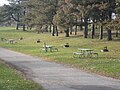
The campground, one of the most popular in southwest Iowa, offers 161 sites, two shower-and-restroom facilities, and a playground. Several picnic areas overlook the reservoir, and 8 open shelters can be reserved for private events.[2]
Recreation
Lake Anita State Park includes a beach and two boat ramps. All boating is at no-wake speeds. Docks are available for seasonal rent. Fishing is geared toward largemouth bass, crappies, and bluegills. A 1-mile (1.6 km) self-guided nature trail interprets the trees and shrubs of the region. A 4-mile (6.4 km) trail for walking and bicycling circles the lake.[2]
-
 Entrance sign
 -
 View of campground
 -
 View of dam and trail


References
- ^ "Lake Ahquabi State Park". Geographic Names Information System. United States Geological Survey. 1979-04-30. Retrieved 2011-02-27.
- ^ a b c "Lake Anita State Park". Iowa Department of Natural Resources. Retrieved 2011-01-27.