
Sevier Lake
| Sevier Lake | |
|---|---|
 Sevier Lake aerial view from the north | |
| Location | Millard County, Utah, United States |
| Coordinates | 38°56′20″N 113°09′43″W / 38.93889°N 113.16194°W |
| Type | intermittent endorheic |
| Primary inflows | Beaver and Sevier rivers |
| Basin countries | United States |
| Surface elevation | 4,550 ft (1,390 m) |
Sevier Lake /sɛˈvɪər/ is an intermittent and endorheic lake which lies in the lowest part of the Sevier Desert, Millard County, Utah. Like Great Salt Lake and Utah Lake, it is a remnant of Pleistocene Lake Bonneville. Sevier Lake is fed primarily by the Beaver and Sevier rivers, and the additional inflow is from the lake's watershed that is part of the Escalante–Sevier hydrologic subregion.[1] The lake has been mostly dry throughout recorded history and is a source of wind-blown dust in dust storms that frequently sweep the Wasatch Front.[2]

History
The first recorded observation was in 1872, which stated that the lake's surface area was 188 square miles (490 km2), salinity was measured at 86 parts per thousand, two and a half times that of the ocean, and maximum depth was 15 feet (4.6 m). In January 1880 the lake was nearly dry, and had been so for the past one or two years. The Sevier River which once flowed to the lake is now largely diverted for irrigation. In 1987 however, the lake was again similar to the recorded description of 1872.
The Dominguez–Escalante Expedition named it "Laguna de Miera" after a cartographer on their 1776 expedition. In 1825, trappers working for William Henry Ashley trapped the region, and Jedediah Smith named it after him, the Ashley Lake. On some maps, it was named after Joseph Nicollet in the mid-19th century. The lake is currently named for the river, which is derived from "Rio Severo" (wild river [Wild in modern Spanish is Salvaje, or Silvestre]), a local name given by early Spanish explorers.[3]
Water
During late 2011, due to an unusually wet year, many man-made reservoirs in Millard County began dumping excess water through the Sevier River onto the Sevier Lake bed.[4] Standing water existed on the playa for the first time since 1984 and extended down past Needle Point, which is the feature seen on the west edge of the lake. In the deepest points water levels were over three feet deep. Due to high salinity content, of over 20% TDS, the water never fully froze from the winter temperatures, which were well below freezing, except near the inlet of the Sevier River.
Potash mining
Currently an exploration-stage sulphate of potash mine project is underway on Sevier Lake. This is being headed up by Crystal Peak Minerals (CPM).[5] Extensive exploration drilling has been completed over the entire playa and in 2013 CPM announced a measured and indicated resource estimate of 31.486 Mt of potassium sulfate.[6]
Climate
| Climate data for years 1987–1993 Sevier Dry Lake, Utah (elevation 4,550 ft) | |||||||||||||
|---|---|---|---|---|---|---|---|---|---|---|---|---|---|
| Month | Jan | Feb | Mar | Apr | May | Jun | Jul | Aug | Sep | Oct | Nov | Dec | Year |
| Record high °F (°C) | 68 (20) |
69 (21) |
78 (26) |
86 (30) |
91 (33) |
102 (39) |
104 (40) |
102 (39) |
94 (34) |
87 (31) |
77 (25) |
60 (16) |
104 (40) |
| Mean daily maximum °F (°C) | 35.6 (2.0) |
40.7 (4.8) |
56.6 (13.7) |
65.7 (18.7) |
75.1 (23.9) |
87.4 (30.8) |
96.2 (35.7) |
91.3 (32.9) |
82.7 (28.2) |
70.2 (21.2) |
49.5 (9.7) |
36.1 (2.3) |
65.6 (18.7) |
| Mean daily minimum °F (°C) | 8.9 (−12.8) |
13.7 (−10.2) |
30.6 (−0.8) |
35.4 (1.9) |
42.8 (6.0) |
52.1 (11.2) |
61.5 (16.4) |
56.0 (13.3) |
46.3 (7.9) |
36.4 (2.4) |
23.5 (−4.7) |
10.7 (−11.8) |
34.8 (1.6) |
| Record low °F (°C) | −18 (−28) |
−31 (−35) |
9 (−13) |
14 (−10) |
25 (−4) |
32 (0) |
49 (9) |
30 (−1) |
28 (−2) |
20 (−7) |
−7 (−22) |
−21 (−29) |
−31 (−35) |
| Average precipitation inches (mm) | 0.38 (9.7) |
0.39 (9.9) |
1.05 (27) |
0.46 (12) |
0.78 (20) |
0.56 (14) |
0.38 (9.7) |
0.75 (19) |
0.49 (12) |
0.89 (23) |
0.45 (11) |
0.36 (9.1) |
6.96 (177) |
| Average snowfall inches (cm) | 5.0 (13) |
5.3 (13) |
2.0 (5.1) |
0.0 (0.0) |
0.0 (0.0) |
0.0 (0.0) |
0.0 (0.0) |
0.0 (0.0) |
0.0 (0.0) |
0.0 (0.0) |
1.6 (4.1) |
6.9 (18) |
20.8 (53) |
| Source: The Western Regional Climate Center[7] | |||||||||||||
Gallery
-
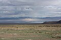 Sevier Lake after a late summer thunderstorm
 -
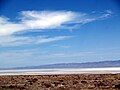 As seen from US 50 in 2009
 -
 Aerial view from the east in 2011


References
- ^ "Escalante–Sevier Watershed".
- ^ "Archived copy". Archived from the original on 2014-08-10. Retrieved 2014-07-04.
{{cite web}}: Unknown parameter|deadurl=ignored (|url-status=suggested) (help)CS1 maint: archived copy as title (link) - ^ Van Cott, J. W., 1990, Utah Place Names, ISBN 0-87480-345-4
- ^ "Sevier River Surplus Water". Archived from the original on 2012-03-25.
{{cite web}}: Unknown parameter|deadurl=ignored (|url-status=suggested) (help) - ^ "Crystal Peak Minerals". Crystal Peak Minerals. 2017. Retrieved July 4, 2014.
- ^ "EPM Mining Announces Results of Preliminary Feasibility Study for Its Sevier Lake Playa Sulphate of Potash Project". Yahoo. 2013. Retrieved July 4, 2014.
- ^ "Seasonal Temperature and Precipitation Information". Western Regional Climate Center. Retrieved March 29, 2013.
- Terminal Lake Systems - Sevier Lake. Utah Water Research Laboratory, Utah State University
- Utah History Encyclopedia.
- Sevier River Flooding 1983-1984. WaterHistory.org