Jump to content

Sōraku District, Kyoto

Coordinates: 34°46′08″N 135°57′40″E / 34.769°N 135.961°E / 34.769; 135.961
From Wikipedia, the free encyclopedia

This is the current revision of this page, as edited by RealFakeKim (talk | contribs) at 18:50, 19 April 2021 (clean up, typo(s) fixed: km² → km<sup>2</sup> (2)). The present address (URL) is a permanent link to this version.

(diff) ← Previous revision | Latest revision (diff) | Newer revision → (diff)
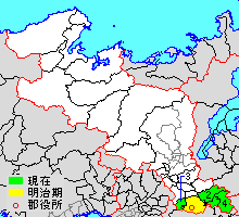
Location of Sōraku in Kyoto prefecture

Sōraku (相楽郡, Sōraku-gun) is a district in Kyoto Prefecture, Japan.

As of 2007, the district had an estimated population of 44,982 and a density of 252.27 persons per km2. The total area is 178.31 km2.

Towns and villages

[edit]

Former towns

[edit]

The following towns merged to create the new city of Kizugawa on March 12, 2007.

34°46′08″N 135°57′40″E / 34.769°N 135.961°E / 34.769; 135.961