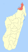
Ambanja District
Appearance
Ambanja District | |
|---|---|
District | |
 Location in Madagascar | |
| Coordinates: 13°40′43″S 48°27′8″E / 13.67861°S 48.45222°E | |
| Country | |
| Region | Diana |
| Area | |
• Total | 5,999.72 km2 (2,316.50 sq mi) |
| Population (2013) | |
• Total | 190,435 |
| • Density | 32/km2 (82/sq mi) |
| • Ethnicities | Sakalava |
| Time zone | UTC3 (EAT) |
Ambanja is a district in northern Madagascar. It is a part of Diana Region and borders the districts of Ambilobe to the east, Bealanana to the south and Analalava to the south-west. The area is 5,999.72 km2 (2,317 sq mi) and the population was estimated at 190,435 in 2013.[1]
Communes
The district is further divided into 18 communes:
- Ambalahonko
- Ambanja
- Ambodimanga
- Ambohimarina
- Ankatafa
- Ankingameloko
- Anorotsangana
- Antafiambotry
- Antranokarany
- Antsakoamanondro
- Antsatsaka
- Antsirabe
- Bemanevika Haut Sambirano
- Bemaneviky Ouest
- Djangoa
- Maherivaratra
- Marotolana
- Marovato
References and notes
- ^ Instituit National de la Statistique, Antananarivo.

