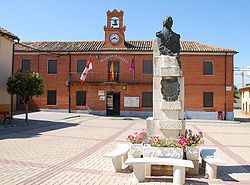
Cervatos de la Cueza
Appearance
Cervatos de la Cueza | |
|---|---|
 | |
 | |
| Country | |
| Autonomous community | |
| Province | |
| Municipality | Cervatos de la Cueza |
| Area | |
• Total | 71.46 km2 (27.59 sq mi) |
| Elevation | 849 m (2,785 ft) |
| Population (2018)[1] | |
• Total | 262 |
| • Density | 3.7/km2 (9.5/sq mi) |
| Time zone | UTC+1 (CET) |
| • Summer (DST) | UTC+2 (CEST) |
| Website | Official website |
Cervatos de la Cueza is a municipality located in the province of Palencia, Castile and León, Spain. According to the censuses (INE) since 1900, the population has continued to decline. In 1900 a population of 808 inhabitants was reported, falling to 397 in 2000, and most recently being reported at 262 inhabitants in 2018.

in Quintanilla de la Cueza (Cervatos de la Cueza).
References
- ^ Municipal Register of Spain 2018. National Statistics Institute.


