Angelslo
Angelslo | |
|---|---|
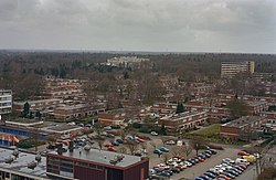
 View on the neighbourhood | |
Location in province of Drenthe in the Netherlands | |
| Coordinates: 52°42′45″N 6°23′56″E / 52.71239°N 6.39894°E | |
| Country | Netherlands |
| Province | Drenthe |
| Municipality | Emmen |
| Area | |
• Total | 13.94 km2 (5.38 sq mi) |
| Elevation | 5 m (16 ft) |
| Population (2021)[1] | |
• Total | 7,645 |
| • Density | 550/km2 (1,400/sq mi) |
| Time zone | UTC+1 (CET) |
| • Summer (DST) | UTC+2 (CEST) |
| Postal code | 7924[1] |
| Dialing code | 0591 |
Angelslo is a neighbourhood of the city Emmen in Drenthe, the Netherlands. It is a former village which was annexed by Emmen.
History
It was first mentioned in 1325 as Angel. The etymology is unknown.[3] In 1932, it was home to 258 people.[4]
The construction of the neighbourhood started in the 1960s. Typical for these buildings are the flat roofs.[5]
Angelslo has two elementary schools: Twiespan and O.B.S. Angelslo.[6] Besides that, Angelslo also has a shopping mall,[7] located at the Statenweg.
Statenweg is the main road that goes through Angelslo and branches off in smaller roads (Landschapslaan, Dingspellaan, Kerspellaan, Boerschapslaan, Holtlaan and Veldlaan), that in their turn branch off again.[8]
There are two churches in Angelslo: Evangelische Gemeente Emmen and Baptisten Gemeente Het Baken.[9] The mosque is located near the shopping mall and is called ISN Yildirim Beyazit Moskee.[10]
Angelslo also has a swimmingpool, Aquarena,[11] which is the only indoor pool of Emmen.
The hospital of Emmen is located on the border of Angelslo.[12]
References
- ^ a b c "Kerncijfers wijken en buurten 2021". Central Bureau of Statistics. Retrieved 13 March 2022.
- ^ "Postcodetool for 7924NZ". Actueel Hoogtebestand Nederland (in Dutch). Het Waterschapshuis. 24 July 2019. Retrieved 13 March 2022.
- ^ "Angeslo". Etymologiebank (in Dutch). Retrieved 13 March 2022.
- ^ Jan Harm Tuntler (1935). In en om de gemeente Emmen (in Dutch). Ten Kate. p. 89.
- ^ "Gemeente Emmen: Angelslo". Archived from the original on 2012-06-12. Retrieved 2012-02-15.
- ^ http://www.emmen.nl/wonen-en-leven/onderwijs-en-studeren/basisscholen/angelslo-emmen.html[permanent dead link]
- ^ "Winkelcentrum Angelslo Statenweg Emmen -". Archived from the original on 2012-05-20. Retrieved 2012-02-15.
- ^ "Statenweg · Emmen".
- ^ "Kerk in emmen op kaart - Telefoonboek - Telefoongids".
- ^ "ISN Yildirim Beyazit Moskee, Emmen".
- ^ "Zwembaden van Drenthe".
- ^ "Scheper Ziekenhuis » Leveste". Archived from the original on 2012-02-21. Retrieved 2012-02-15.


