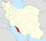
Eram Rural District
Appearance
Eram Rural District
| |
|---|---|
| Coordinates: 29°16′35″N 51°32′46″E / 29.27639°N 51.54611°E[1] | |
| Country | |
| Province | Bushehr |
| County | Dashtestan |
| District | Eram |
| Capital | Tang-e Eram |
| Population (2016)[2] | |
• Total | 5,045 |
| Time zone | UTC+3:30 (IRST) |
Eram Rural District (Template:Lang-fa) is in Eram District of Dashtestan County, Bushehr province, Iran. Its capital is the city of Tang-e Eram.
At the census of 2006, its population was 6,116 in 1,217 households;[3] there were 5,120 inhabitants in 1,245 households at the following census of 2011;[4] and in the most recent census of 2016, the population of the rural district was 5,045 in 1,394 households. The largest of its 22 villages was Rud-e Faryab, with 1,917 people.[2]
References
- ^ OpenStreetMap contributors (30 March 2023). "Eram Rural District (Dashtestan County)" (Map). OpenStreetMap. Retrieved 30 March 2023.
- ^ a b "Census of the Islamic Republic of Iran, 1395 (2016)". AMAR (in Persian). The Statistical Center of Iran. p. 18. Archived from the original (Excel) on 3 August 2017. Retrieved 19 December 2022.
- ^ "Census of the Islamic Republic of Iran, 1385 (2006)". AMAR (in Persian). The Statistical Center of Iran. p. 18. Archived from the original (Excel) on 20 September 2011. Retrieved 25 September 2022.
- ^ "Census of the Islamic Republic of Iran, 1390 (2011)" (Excel). Iran Data Portal (in Persian). The Statistical Center of Iran. p. 18. Retrieved 19 December 2022.


