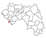
Kaloum
Appearance
Kaloum | |
|---|---|
 | |
| Coordinates: 9°30′33″N 13°42′44″W / 9.50917°N 13.71222°W | |
| Country | |
| Region | Conakry Region |
| Population (2014) | |
• Total | 62,675 |
| Time zone | UTC+0 (GMT) |
Kaloum is an urban sub-prefecture in the Conakry Region of Guinea and one of five in the capital Conakry.[1] Kaloum includes the city centre of Conakry. As of 2014 it had a population of 62,675 people.[2]
The seat of Government is located in Kaloum, including the Presidential Palace, the Palais du Peuple, many ministries, embassies and banks. The Port of Conakry and the fishing port are located there. The Ignace Deen Hospital, one of the first in the nation, was built there in the colonial era. Other notable features include the Sandervalia National Museum and St. Mary's Cathedral, Conakry.
When Air Guinée existed, its head office was in Kaloum.[3]
Gallery
[edit]References
[edit]- ^ "Subprefectures of Guinea". Statoids. Retrieved 20 April 2009.
- ^ "Guinea". Institut National de la Statistique, Guinea, accessed via Geohive. Archived from the original on 24 November 2015. Retrieved 27 August 2014.
- ^ "Bienvenue." Air Guinée. Retrieved 26 February 2010.
9°30′33″N 13°42′44″W / 9.50917°N 13.71222°W


