
Markiezaatskade
The Markiezaatskade is a 4 km (2.5 mi) long dam between Zuid-Beveland and the Molenplaat near Bergen op Zoom.[1] The dam was built in preparation for the construction of the Oesterdam, which was built a few years later. In combination with the Oesterdam, Philipsdam and Volkerakdam it divides the waters of Zeeland and South Holland.

Construction of the Markiezaatskade commenced in 1980. In March 1982 a part of the dam was destroyed by a storm.[2] Construction on the dam was completed by March 30, 1983.[3]
-
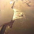 Markiezaatskade during construction
 -
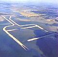 Markiezaatskade in the eastern part of the Oosterschelde near Bergen op Zoom
 -
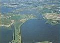 Northern part of the Markiezaatskade


References
- ^ "Markiezaatskade (1980-1983)". Deltawerken.com. Stichting Deltawerken Online. Retrieved January 17, 2019.
- ^ "Miljoenenschade Markiezaatskade". Provinciale Zeeuwse Courant (in Dutch). March 13, 1982. Archived from the original on May 26, 2020. Retrieved January 18, 2019. Alt URL
- ^ "Markiezaatskade voltooid" (in Dutch). March 30, 1983. Retrieved January 18, 2019.
Further reading
- d'Angremond, Kees; van Roode, F. (2004). Breakwaters and Closure Dams. VSSD Delft. pp. 181–. ISBN 978-0-203-40134-7.
- Termaat, R. J.; Calle, E. O. F.; Petschl, R. O. (1988). The Probability of Failure of an in Stages Constructed Embankment on Soft Soil. International Conference on Case Histories in Geotechnical Engineering. St. Louis. pp. 533–540.