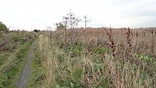
Rainham Marshes Nature Reserve
| Site of Special Scientific Interest | |
 | |
| Location | Greater London Essex |
|---|---|
| Grid reference | TQ531800 |
| Interest | Biological |
| Area | 479.3 hectares |
| Notification | 1986 |
| Location map | Magic Map |

Rainham Marshes is an RSPB nature reserve in the east of London, adjacent to the Thames Estuary in Purfleet, Thurrock and the London Borough of Havering.
History
Before the site was protected as a nature reserve, it was considered as a candidate location for a Universal theme park in the 1990s,[1][2][3] but a site in Paris was eventually chosen.[4][5] This project failed to materialize.[6]
In 2000, the area of land was bought from the Ministry of Defence, who used it as a test firing range.[7] With no activity for several years, the nature reserve was officially opened to the public in 2006. It has maintained much of its medieval landscape, and is the largest area of wetland on the upper parts of the Thames Estuary.
The reserve
The reserve is home to a diverse range of bird species, wetland plants and insects. It also has one of the densest water vole populations in the country. In December 2005, the site was visited by a sociable lapwing; over 1,700 people visited the reserve to see this bird. Late in the bird's stay, four penduline tits were also found at the site. Entrance to the site is free to residents of Thurrock and the London Borough of Havering.[8]
The site is home to an environmentally friendly visitor centre which features solar panels, rainwater harvesting, natural light and ventilation and a ground heat exchange system.[9] This visitor centre, completed in 2006 at a cost £2 million, was designed by van Heyningen and Haward Architects[10] The building won six awards for its BREEAM sustainable design, including a Green Apple Award, Regeneration and Renewal Award and a Royal Institute of British Architects National Award.[11]
The site is part (77% according to a BBC article[12]) of a Site of Special Scientific Interest (SSSI) called Inner Thames Marshes,[13][14] and the part which is in the London Borough of Havering has been designated by the council as a Site of Metropolitan Importance for Nature Conservation called Wennington, Aveley and Rainham Marshes.[15][16] The area west of a drain running south from Brookway is a Local Nature Reserve (LNR), as well as being part of the SSSI.[17][18] South of the A13 road the LNR is part of the RSPB reserve, while the northern part is managed by Havering Council.
Landfill
The marshes to the west of the nature reserve have been used as a landfill site for rubbish from London and the local area. Rainham Landfill is operated by Veolia ES Landfill Limited.[19] The site occupies an area of 177 hectares, and accepts up to 1,500,000 tonnes per year. This includes up to 70,000 tonnes per year in a Materials Recovery Facility and 70,000 tonnes per year of Green Waste.[19] There are facilities for soil washing and a Leachate Treatment Plant. The decomposition of organic matter within the landfill generates a gas containing up to about 50 percent methane. This landfill gas is collected by a network of pipes and since 2001 has been used in an onsite power station. The station is owned and operated by EDL. The plant comprises eight 1.25 MW, three 1.4 MW, two 1.1 MW and one 1.0 MW reciprocating engines which drive electricity generating sets.[20] The electricity produced is fed into the National Grid. The station has a generating capacity of 17.8 MW and typically generates 95 GWh of electricity per year. This is equivalent to powering 14,600 homes. The site is expected to produce landfill gas for electricity generation to beyond 2030.[20]
See also
- List of Sites of Special Scientific Interest in Greater London
- List of Sites of Special Scientific Interest in Essex
- Havering parks and open spaces
References
- ^ Pierre Bary (12 March 1990). "Euro Disneyland à Marne-la-Vallée au rendez-vous de 1992". Le Soir (in French). Retrieved 17 September 2019.
- ^ "08Jun90 UK: DECISION EXPECTED SOON ON WHETHER 'UNIVERSAL CITY' WILL BE BUILT AT RAINHAM MARSHES. (1 OF 2)". Construction News. 7 June 1990. Retrieved 1 December 2021.
- ^ "08Jun90 UK: DECISION EXPECTED SOON ON WHETHER 'UNIVERSAL CITY' WILL BE BUILT AT RAINHAM MARSHES. (2 OF 2)". Construction News. 7 June 1990. Retrieved 1 December 2021.
- ^ Michael Williams (14 April 1993). "MCA in talks to become Euro Disney neighbor". Variety. Retrieved 1 December 2021.
- ^ "Master Planning MCA - Universal Studios Movie World". dsewing.com. 10 January 1990. Retrieved 1 December 2021.
- ^ "Universal over de hele wereld". parkplanet.nl (in Dutch). Retrieved 1 December 2021.
- ^ Wetland Vision website
- ^ RSPB - Rainham Marshes
- ^ RSPB - About Rainham Marshes
- ^ "RSPB Environment and Education Centre, Rainham". van Heyningen and Haward. Archived from the original on 2011-09-30. Retrieved 2011-08-10.
- ^ van Heyningen and Haward awards Archived 2013-02-28 at the Wayback Machine
- ^ "Rainham Marshes - June Diary". BBC. 28 October 2014. Retrieved 25 September 2016.
- ^ Inner Thames Marshes citation, Natural England
- ^ "Map of Inner Thames Marshes SSSI". Natural England.
- ^ "Wennington, Aveley and Rainham Marshes". Greenspace Information for Greater London. 2013.
- ^ "iGiGL – helping you find London's parks and wildlife sites (map)". Greenspace Information for Greater London. 2013. Archived from the original on 2012-10-15.
- ^ "Rainham Marshes". Local Nature Reserves. Natural England. 6 March 2013. Retrieved 22 January 2014.
- ^ "Map of Rainham Marshes". Local Nature Reserves. Natural England. Retrieved 22 January 2014.
- ^ a b "Rainham Landfill Site". Veolia. Retrieved 19 July 2020.
- ^ a b "Rainham Landfill Gas Power Station" (PDF). EDL Energy. Retrieved 19 July 2020.


