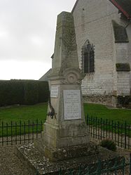
Aubeterre
Aubeterre | |
|---|---|
 War memorial | |
| Coordinates: 48°25′50″N 4°07′15″E / 48.4306°N 4.1208°E | |
| Country | France |
| Region | Grand Est |
| Department | Aube |
| Arrondissement | Troyes |
| Canton | Arcis-sur-Aube |
| Intercommunality | CA Troyes Champagne Métropole |
| Government | |
| • Mayor (2020–2026) | Jean-Marie Beaussier[1] |
Area 1 | 11.66 km2 (4.50 sq mi) |
| Population (2021)[2] | 385 |
| • Density | 33/km2 (86/sq mi) |
| Time zone | UTC+01:00 (CET) |
| • Summer (DST) | UTC+02:00 (CEST) |
| INSEE/Postal code | 10015 /10150 |
| Elevation | 124 m (407 ft) |
| 1 French Land Register data, which excludes lakes, ponds, glaciers > 1 km2 (0.386 sq mi or 247 acres) and river estuaries. | |
Aubeterre (French pronunciation: [obtɛʁ]) is a commune in the Aube department in the Grand Est region of north-central France.
The inhabitants of the commune are known as Aubeterriens or Aubeterriennes.[3]
Geography
Aubeterre is located some 25 km north by north-east of Troyes and 17 km south by south-west of Arcis-sur-Aube. Access to the commune is by the D677 road from Voué in the north passing through the length of the commune and the village and continuing to Feuges in the south. The commune is entirely flat farmland.[4]
The commune is served by the Procars Champagne Bus No. 7 bus from Troyes (bus station) to Arcis-sur-Aube and Mailly-le-Camp and vice versa.
Neighbouring communes and villages
History
Before being called Aubeterre the name of the commune was Alba-Terra. On 1 January 2011 the communes of Aubeterre and Montsuzain integrated into the Community of communes Seine Melda Coteaux. A Primary Elementary School is located in the heart of the village next to City Hall. A coffee shop the Betty Boop-Diner is located on the D677 in the village. In late August 2013 the coffee shop changed its name and became Le Relais des amis (The Inn of friends).
Administration
List of Successive Mayors[5]
| From | To | Name |
|---|---|---|
| 1857 | Jobert | |
| 2001 | 2026 | Jean-Marie Beaussier |
Demography
In 2017 the commune had 357 inhabitants.
|
| ||||||||||||||||||||||||||||||||||||||||||||||||||||||||||||||||||||||||||||||||||||||||||||||||||||||||||||||||||
| |||||||||||||||||||||||||||||||||||||||||||||||||||||||||||||||||||||||||||||||||||||||||||||||||||||||||||||||||||
| Source: EHESS[6] and INSEE[7] | |||||||||||||||||||||||||||||||||||||||||||||||||||||||||||||||||||||||||||||||||||||||||||||||||||||||||||||||||||
Sites and monuments
The Church of the Purification of the Virgin dates from the 12th and 15th centuries. The Corbels of the prophets are unusual with their Speech scrolls.
The Church contains many items which are registered as historical objects:
- A Celebrant Chair (18th century)
 [8]
[8] - Ceramic tiling (13th century)
 [9]
[9] - A Statue: Saint John the Baptist (16th century)
 [10]
[10] - Stained glass (16th century)
 [11]
[11] - A Statuette: Saint Marguerite (disappeared) (16th century)
 [12]
[12] - A Statue: Virgin and Child (15th century)
 [13]
[13] - A Statue: Saint Bishop (14th century)
 [14]
[14] - A Statue: Virgin in prayer (16th century)
 [15]
[15] - A Bronze Bell (1770)
 [16]
[16] - A Paten (1819)
 [17]
[17] - A Chalice (19th century)
 [18]
[18] - An old door and hinges (16th century)
 [19]
[19] - Some benches with balustrades (1795)
 [20]
[20] - A Monumental painting (15th century)
 [21]
[21] - A Stoup (16th century)
 [22]
[22] - A Baptismal Font (16th century)
 [23]
[23] - A Monumental painting (16th century)
 [24]
[24]
See also
References
- ^ "Répertoire national des élus: les maires". data.gouv.fr, Plateforme ouverte des données publiques françaises (in French). 2 December 2020.
- ^ "Populations légales 2021" (in French). The National Institute of Statistics and Economic Studies. 28 December 2023.
- ^ Inhabitants of Aube (in French)
- ^ a b Google Maps
- ^ List of Mayors of France (in French)
- ^ Des villages de Cassini aux communes d'aujourd'hui: Commune data sheet Aubeterre, EHESS (in French).
- ^ Population en historique depuis 1968, INSEE
- ^ Ministry of Culture, Palissy PM10004799 Celebrant Chair (in French)

- ^ Ministry of Culture, Palissy PM10004798 Ceramic tiling (in French)

- ^ Ministry of Culture, Palissy PM10000058 Statue: Saint John the Baptist (in French)

- ^ Ministry of Culture, Palissy PM10000057 Stained glass (in French)
- ^ Ministry of Culture, Palissy PM10000056 Statuette: Saint Marguerite (disappeared - probably stolen) (in French)
- ^ Ministry of Culture, Palissy PM10000055 Statue: Virgin and Child (in French)

- ^ Ministry of Culture, Palissy PM10000054 Statue: Saint Bishop (in French)

- ^ Ministry of Culture, Palissy IM100012845 Statue: Virgin in prayer (in French)

- ^ Ministry of Culture, Palissy IM10012844 Bronze Bell (in French)

- ^ Ministry of Culture, Palissy IM10012843 Paten (in French)

- ^ Ministry of Culture, Palissy IM10012842 Chalice (in French)

- ^ Ministry of Culture, Palissy IM10012841 Door and hinges (in French)

- ^ Ministry of Culture, Palissy IM10012840 Benches with balustrades (in French)

- ^ Ministry of Culture, Palissy IM10012839 Monumental painting (in French)

- ^ Ministry of Culture, Palissy IM10012838 Stoup (in French)

- ^ Ministry of Culture, Palissy IM10012802 Baptismal Font (in French)

- ^ Ministry of Culture, Palissy IM10012801 Monumental painting (in French)

External links
- Aubeterre on the old IGN website (in French)
- Aubeterre on Géoportail, National Geographic Institute (IGN) website (in French)
- Aubeterre on the 1750 Cassini Map


