Rulindo District
Appearance
Rulindo District | |
|---|---|
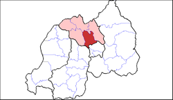
 Shown within Northern Province and Rwanda | |
| Country | Rwanda |
| Province | Northern |
| Capital | kinini |
| Area | |
• District | 566.7 km2 (218.8 sq mi) |
| Population (2022 census)[1] | |
• District | 360,144 |
| • Density | 640/km2 (1,600/sq mi) |
| • Urban | 38,110 |
| • Rural | 322,034 |
Rulindo is a district (akarere) in Northern Province, Rwanda. Its capital is MUGOTE (also known as REMERA).
Geography
The district lies roughly halfway between Kigali and Ruhengeri, and is very mountainous, containing Mount Kabuye. Its principal town, Tare (more commonly known as Nyirangarama), serves as a rest and refreshment stop for most long distance bus services between Kigali and Gisenyi and Goma.
Economy

Rulindo district is home to Agashya, Rwanda's leading manufacturer of passion fruit squash. Kinihira Sector is home to the Sorwathe Tea Factory.
Sectors
Rulindo district is divided into 17 sectors (imirenge): Base, Burega, Bushoki, Buyoga, Cyinzuzi, Cyungo, Kinihira, Kisaro, Masoro, Mbogo, Murambi, Ngoma, Ntarabana, Rukozo, Rusiga, Shyorongi and Tumba.
References
- ^ Citypopulation.de Population of Rulindo District
Sources
- "Districts of Rwanda". Statoids.
- Inzego.doc — Province, District and Sector information from MINALOC, the Rwanda ministry of local government.
