Rancho Tularcitos
Rancho Tularcitos
Los Tularcitos | |
|---|---|
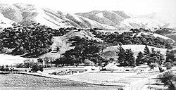
 View of Rancho Tularcitos from west of the ranch, circa 1960s | |
 | |
| Coordinates: 36°28′12″N 121°37′48″W / 36.47000°N 121.63000°W | |
| Country | United States |
| State | California |
| County | Monterey County |
| Area | |
• Total | 26,581 acres (10,757 ha) |
Rancho Tularcitos was a 26,581-acre (107.57 km2) Mexican land grant in present day Monterey County, California given in 1834 by Governor José Figueroa to Rafael Goméz.[1] Tularcitos means "place of the little Tule thickets". The grant was in the upper Carmel Valley, along Tularcitos Creek, and was bounded on the west by Rancho Los Laureles.[2]
History


Rafael Goméz (1784-1838), born in Mexico, came to California in 1830 as a legal advisor to Governor Manuel Victoria. In 1831, he married Joséfa Antonia Estrada (1813-1890), a daughter of José Mariano Estrada, grantee of Rancho Buena Vista. Goméz was a supporter of Figueroa, but resigned his position, and was granted the six square league Rancho Tularcitos in 1834. He held public offices in Monterey in 1835-36. Rafael Goméz died in an accident on Rancho Tularcitos in 1838.
With the cession of California to the United States following the Mexican-American War, the 1848 Treaty of Guadalupe Hidalgo provided that the land grants would be honored. As required by the Land Act of 1851, a claim for Rancho Tularcitos was filed with the Public Land Commission in 1852,[3][4] and the grant was patented to Joséfa Antonia Estrada de Gomez in 1866.[5]
After Rafael Gomez died in 1838, Joséfa Antonia Gomez married Charles Wolter, a German sea captain of a Mexican ship, who settled in Monterey in 1833. Joséfa Antonia Goméz sold Rancho Tularcitos to Andrew J. Ogletree. Ogletree lost the rancho to Alberto Trescony, owner of Rancho San Lucas, in a mortgage foreclosure in 1880. Trescony gradually sold off the land, except for 2,000-acre (8.1 km2).[6] Andrius Blomquist was born in Sweden in 1846 and emigrated to the United States in 1867 to start a new life. He eventually settled in upper Carmel Valley in 1885 and acquired nearly 8,000-acre (32 km2) of Rancho Tularcitos.
In 1924, Rancho Tularcitos came under the ownership of John E. Marble, and the Marble family took on the responsibility of managing the ranching operations for a considerable duration thereafter.[7] The ranch was eventually divided between his sons, John M. and Robert. John M. inherited the ranch headquarters, while Robert received the eastern section of the ranch. By the late 1940s, Bill Dorrance served as the ranch superintendent. Robert Marble decided to rename his portion of the ranch to Rana Creek Ranch.[8]
Mike Markkula bought the 14,000 acres (5,700 ha) Rana Creek Ranch in 1982 from the Marble family.[9] The Wildlands Conservancy acquired Rana Creek Ranch in 2023 and plans to open it to the public.[10]
See also
References
- ^ Ogden Hoffman, 1862,Reports of Land Cases Determined in the United States District Court for the Northern District of California, Numa Hubert, San Francisco
- ^ "[Diseño del Rancho Los Tularcitos : Calif.]".
- ^ United States. District Court (California : Southern District) Land Case 3 SD
- ^ Finding Aid to the Documents Pertaining to the Adjudication of Private Land Claims in California, circa 1852-1892
- ^ Report of the Surveyor General 1844 - 1886 Archived 2009-05-04 at the Wayback Machine
- ^ Fink, Augusta (2000). Monterey County: The Dramatic Story of its Past. Valley Publishers. ISBN 9780913548622. Retrieved 2020-07-19.
- ^ Hoover, Mildred B.; Rensch, Hero; Rensch, Ethel; Abeloe, William N. (1966). Historic Spots in California. Stanford University Press. ISBN 978-0-8047-4482-9.
- ^ Jeff Ohlson. "A History of Ranching in Carmel Valley". Carmel Valley Historical Society. Carmel Valley, California. p. 123-125. Retrieved 2023-06-19.
- ^ "The Carmel Pine Cone In YourDreams" (PDF). Carmel Pine Cone. Carmel-by-the-Sea, California. October 6, 2017. p. 8. Retrieved 2023-06-19.
- ^ Rogers, Paul (June 18, 2023). "Apple co-founder to sell huge Carmel Valley ranch for $35 million to become public nature preserve". Santa Cruz Sentinel. Retrieved 2023-06-19.

