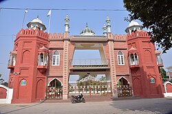
Malerkotla district
This article needs additional citations for verification. (May 2021) |
Malerkotla district | |
|---|---|
 Eidgah in Malerkotla | |
 Location in Punjab | |
| Coordinates: 30°32′N 75°53′E / 30.53°N 75.88°E | |
| Country | |
| State | Punjab |
| Division | Patiala |
| Established | 02 June 2021 |
| Headquarters | Malerkotla |
| Government | |
| • Deputy Commissioner | Sh.Sanyam Agarwal, IAS |
| • Senior Superintendent of Police | Smt. Alka Meena IPS |
| Area | |
• Total | 684 km2 (264 sq mi) |
| Population (2011) | |
• Total | 429,754 |
| • Rank | 23rd |
| • Density | 629/km2 (1,630/sq mi) |
| Languages | |
| • Official | Punjabi |
| Time zone | UTC+5:30 (IST) |
| PIN | 148XXX |
| Vehicle registration | PB-28(for Malerkotla) PB-76(for Ahmedgarh) PB-82(for Ahmedgarh SDM) PB-92(for Amargarh) |
| Nearest city | Malerkotla |
| Sex ratio | 896 ♂/♀ |
| Literacy | 76.28% |
| Lok Sabha constituency | Sangrur Fatehgarh Sahib |
| Punjab Legislative Assembly constituency | 2
•Malerkotla •Amargarh |
| Precipitation | 450 millimetres (18 in) |
| Avg. summer temperature | 48 °C (118 °F) |
| Avg. winter temperature | 7 °C (45 °F) |
| Website | malerkotla |
Malerkotla district is a district in Punjab state of India. It was formed after the bifurcation of Sangrur district.[1] Malerkotla district was carved out of Sangrur and became the 23rd district of Punjab on 02 June, 2021. District Malerkotla is divided into three subdivisions: Malerkotla, Amargarh and Ahmedgarh.
History
Malerkotla was Malerkotla State a princely state from 1454 until 20 August 1948 when it became a part of Patiala and East Punjab States Union. It was merged with Punjab in 1956 and became a part of the Sangrur district.
Administration
Malerkotla district is in the state of Punjab in northern India. It is the 23rd district in the Indian state of Punjab.[2] The district was carved out of Sangrur district on 14 May, 2021.[3] Subdivisions of Malerkotla, Ahmedgarh and the sub-tehsil of Amargarh are part of the district.[4]
Demographics
Malerkotla district has a population of 429,754 according to the 2011 census.[5] It has an area of 684 Sq Km. It has 3 revenue divisions , municipalities & CD Blocks. There are 175 Gram Panchayats & 192 villages. 40.50% of the population lives in urban areas. Scheduled Castes make up 93,047 (21.65%) of the population.[6]
Sikhism is the majority religion, and is mainly rural. Unlike the rest of erstwhile Punjab, the Muslims of Malerkotla did not move to Pakistan during Partition and Malerkotla still has a sizeable minority of Muslims.[1] Hindus are the third-largest community in urban areas.[7]
At the time of the 2011 census, 96.69% of the population spoke Punjabi and 3.21% Urdu as their first language.[8]
Politics
Malerkotla district is part of the Malerkotla Assembly constituency. Mohammad Jamil Ur Rehman (AAP) is the MLA since 2022.[9]
The district is part of the Sangrur Lok Sabha constituency. By-election to Sangrur Lok Sabha constituency was held on 23 June 2022 and Simranjit Singh Mann was selected as the MP.[10]
Notable people
- Qimat Rai Gupta, an entrepreneur, and founder, former chairman and managing director of Havells, a global electrical company
- Tarlochan Singh Kler, an interventional cardiologist, medical administrator, writer, chairman at Fortis Heart and Vascular Institute, and receiver of Padam Bhushan award
Gallery
Monuments and attractions of Malerkotla
-
Gurudwara Sahib Haaw Da Naara
-
Mubarak Manzil Palace
-
Qila
-
Railways Station
-
Eidgah
See also
References
- ^ a b "Punjab CM declares state's only Muslim-majority town Malerkotla as district on Eid". Retrieved 2021-05-18.
- ^ "Malerkotla is Punjab's 23rd district". The Hindu. 2021-05-14. ISSN 0971-751X. Retrieved 2021-05-14.
- ^ "Malerkotla is Punjab's 23rd district". The Hindu. 2021-05-14. ISSN 0971-751X. Retrieved 2021-05-14.
- ^ Malerkotla to be 23rd District of Punjab 14 May 2021, The Tribune. Retrieved 14 May 2021.
- ^ "Demography | District Malerkotla, Government of Punjab | India". Retrieved 2022-05-16.
- ^ "District Census Handbook: Sangrur" (PDF). Census of India. Registrar General and Census Commissioner of India. 2011.
- ^ a b "Table C-01 Population by Religious Community: Punjab". censusindia.gov.in. Registrar General and Census Commissioner of India.
- ^ a b "Table C-16 Population by Mother Tongue: Punjab". censusindia.gov.in. Registrar General and Census Commissioner of India.
- ^ "Election results". Retrieved 26 May 2022.
- ^ "Sangrur Lok Sabha bypoll on June 23". Tribuneindia News Service. Retrieved 26 May 2022.


