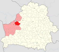
Iwye District
Appearance
Iwye District
| |
|---|---|
 | |
| Coordinates: 53°55′N 25°46′E / 53.917°N 25.767°E | |
| Country | Belarus |
| Region | Grodno Region |
| Administrative center | Iwye |
| Area | |
• Total | 1,841 km2 (711 sq mi) |
| Population (2023)[1] | |
• Total | 20,107 |
| • Density | 11/km2 (28/sq mi) |
| Time zone | UTC+3 (MSK) |
Iwye District (Template:Lang-be; Template:Lang-ru) is a district (raion) of Grodno Region in Belarus. The administrative center is Iwye.[1] Another notable settlement is Hieraniony (Gieraniony), a small historic town with two Category II objects of national cultural heritage (the castle and the parish church).[2]
Notable residents
- Jan Pazniak (1887 or 1895, Subotniki – after October 1939), Belarusian politician and publisher, victim of Soviet repressions[3]
- Zianon Pazniak (born 24 April 1944), Belarusian politician, one of the founders of the Belarusian Popular Front and leader of the Conservative Christian Party – BPF[4]
References
- ^ a b "Численность населения на 1 января 2023 г. и среднегодовая численность населения за 2022 год по Республике Беларусь в разрезе областей, районов, городов, поселков городского типа". belsat.gov.by. Archived from the original on 17 April 2023. Retrieved 5 August 2023.
- ^ List of protected monuments on the official site of Iwye Rajon (in Belarusian). Archived 2014-07-14 at the Wayback Machine
- ^ ПАЗНЯК Янка (Pazniak Janka) www.marakou.by.
- ^ Zianon Pazniak (Пазьняк Зянон Станіслававіч)


