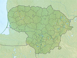
Elektrėnai Reservoir
Appearance
This article includes a list of general references, but it lacks sufficient corresponding inline citations. (August 2021) |
| Elektrėnai Reservoir | |
|---|---|
 Elektrėnai Reservoir with Elektrėnai power plant in the distance | |
| Coordinates | 54°45′20″N 24°40′29″E / 54.75556°N 24.67472°E |
| Type | Artificial lake / reservoir |
| Primary inflows | Strėva River, and 9 other rivulets |
| Primary outflows | Strėva River |
| Basin countries | Lithuania |
| Max. length | 11 km (6.8 mi) |
| Max. width | 3.1 km (1.9 mi) |
| Surface area | 1,264 ha (3,120 acres) |
| Max. depth | 31 m (102 ft) |
| Shore length1 | 34.1 km (21.2 mi) |
| Islands | 18 islands cover 50.5 ha (125 acres) |
| Settlements | Elektrėnai |
| 1 Shore length is not a well-defined measure. | |
Elektrėnai Reservoir (Lithuanian: Elektrėnų marios), located south of the city of Elektrėnai, Lithuania, is the third-biggest artificial lake in Lithuania. It was created in 1961 by damming the Strėva River. It supplies cooling water to the 1,800 MW Elektrėnai Power Plant. A number of villages were drowned by the reservoir; over 140 households were relocated. The reservoir also covered eight other lakes.
The reservoir covers about 1,264 hectares, with depths of over 30 meters.[1]
References
Sources
- Elektrėnai, Vilnius: Jandrija, 2006

