Babolsar County
Babolsar County
| |
|---|---|
County | |
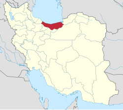
 Location of Babolsar County in Mazandaran province | |
 Location of Mazandaran province in Iran | |
| Coordinates: 36°40′N 52°41′E / 36.667°N 52.683°E[1] | |
| Country | |
| Province | Mazandaran |
| Capital | Babolsar |
| Districts | Central, Bahnemir, Rudbast |
| Area | |
• Total | 345.70 km2 (133.48 sq mi) |
| Population (2016)[3] | |
• Total | 135,191 |
| • Density | 390/km2 (1,000/sq mi) |
| Time zone | UTC+3:30 (IRST) |
| Babolsar County can be found at GEOnet Names Server, at this link, by opening the Advanced Search box, entering "9207228" in the "Unique Feature Id" form, and clicking on "Search Database". | |
Babolsar County (Template:Lang-fa) is in Mazandaran province, Iran, on the Caspian Sea. Its capital is the city of Babolsar.
At the 2006 census, the county's population was 172,600 in 46,595 households.[4] The following census in 2011 counted 124,323 people in 37,838 households, by which time Fereydunkenar District had been separated from the county in the establishment of Fereydunkenar County, which was divided into two districts of two rural districts each, with the city of Fereydunkenar as its capital and only city.[5] At the 2016 census, the county's population was 135,191 in 44,482 households.[3]
Administrative divisions
The population history and structural changes of Babolsar County's administrative divisions over three consecutive censuses are shown in the following table. The latest census shows three districts, six rural districts, and three cities.[3]
| Administrative Divisions | 2006[4] | 2011[5] | 2016[3] |
|---|---|---|---|
| Central District | 67,211 | 72,046 | 80,561 |
| Babolrud RD | 11,644 | 13,178 | 11,244 |
| Saheli RD | 7,695 | 8,391 | 9,351 |
| Babolsar (city) | 47,872 | 50,477 | 59,966 |
| Bahnemir District | 22,090 | 23,284 | 24,001 |
| Azizak RD | 3,860 | 4,224 | 4,283 |
| Bahnemir RD | 11,394 | 11,650 | 11,812 |
| Bahnemir (city) | 6,836 | 7,410 | 7,906 |
| Fereydunkenar District1 | 56,055 | ||
| Barik Rud RD | 4,506 | ||
| Emamzadeh Abdollah RD | 17,097 | ||
| Fereydunkenar (city) | 34,452 | ||
| Rudbast District | 27,244 | 28,988 | 30,629 |
| Khoshk Rud RD | 5,974 | 6,352 | 5,458 |
| Pazevar RD | 17,727 | 18,539 | 17,282 |
| Hadishahr (city) | 3,543 | 4,097 | 7,889 |
| Total | 172,600 | 124,323 | 135,191 |
| RD: Rural District 1Became a part of Fereydunkenar County | |||
References
- ^ OpenStreetMap contributors (23 May 2023). "Babolsar County" (Map). OpenStreetMap. Retrieved 23 May 2023.
- ^ Management and Planning Organization of Mazandaran, 2006 [1] Archived 2013-11-16 at the Wayback Machine
- ^ a b c d "Census of the Islamic Republic of Iran, 1395 (2016)". AMAR (in Persian). The Statistical Center of Iran. p. 02. Archived from the original (Excel) on 7 October 2021. Retrieved 19 December 2022.
- ^ a b "Census of the Islamic Republic of Iran, 1385 (2006)". AMAR (in Persian). The Statistical Center of Iran. p. 02. Archived from the original (Excel) on 20 September 2011. Retrieved 25 September 2022.
- ^ a b "Census of the Islamic Republic of Iran, 1390 (2011)" (Excel). Iran Data Portal (in Persian). The Statistical Center of Iran. p. 02. Retrieved 19 December 2022.
