
Reichertshausen
Reichertshausen | |
|---|---|
 Coat of arms | |
Location of Reichertshausen within Pfaffenhofen a.d.Ilm district 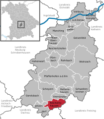 | |
 Reichertshausen  Reichertshausen | |
| Coordinates: 48°28′N 11°31′E / 48.467°N 11.517°E | |
| Country | Germany |
| State | Bavaria |
| Admin. region | Oberbayern |
| District | Pfaffenhofen a.d.Ilm |
| Government | |
| • Mayor | Reinhard Heinrich (CSU) |
| Area | |
| • Total | 23.59 km2 (9.11 sq mi) |
| Elevation | 448 m (1,470 ft) |
| Population (2023-12-31)[1] | |
| • Total | 5,200 |
| • Density | 220/km2 (570/sq mi) |
| Time zone | UTC+01:00 (CET) |
| • Summer (DST) | UTC+02:00 (CEST) |
| Postal codes | 85293 |
| Dialling codes | 08441, 08137 |
| Vehicle registration | PAF |
| Website | www.reichertshausen.de |
Reichertshausen is a municipality in the district of Pfaffenhofen in Bavaria in Germany and is near the A9 and between Munich and Ingolstadt.
Geography
The Bundesstrasse 13 (B13) runs through Reichertshausen. Also the river Ilm, which gives the valley (Ilmtal) its name and is a tributary to the Abens, runs through the town.
District
- Bärnhausen
- Grafing
- Gründholm
- Gurnöbach
- Haunstetten
- Kreut
- Langwaid
- Lausham
- Salmading
- Oberpaindorf
- Paindorf
- Pischelsdorf
- Steinkirchen
References
- ^ Genesis Online-Datenbank des Bayerischen Landesamtes für Statistik Tabelle 12411-003r Fortschreibung des Bevölkerungsstandes: Gemeinden, Stichtag (Einwohnerzahlen auf Grundlage des Zensus 2011).
Towns and municipalities in Pfaffenhofen (district) | ||
|---|---|---|
| International | |
|---|---|
| National | |
| Geographic | |
This Pfaffenhofen district location article is a stub. You can help Wikipedia by expanding it. |