
Čechy pod Kosířem
Čechy pod Kosířem | |
|---|---|
 Panorama of Čechy pod Kosířem | |
 Flag  Coat of arms | |
 Čechy pod Kosířem Location in the Czech Republic | |
| Coordinates: 49°33′4″N 17°2′16″E / 49.55111°N 17.03778°E | |
| Country | |
| Region | Olomouc |
| District | Prostějov |
| First mentioned | 1131 |
| Area | |
| • Total | 9.18 km2 (3.54 sq mi) |
| Elevation | 275 m (902 ft) |
| Population (2020-01-01[1]) | |
| • Total | 1,044 |
| • Density | 110/km2 (290/sq mi) |
| Time zone | UTC+1 (CET) |
| • Summer (DST) | UTC+2 (CEST) |
| Postal code | 798 58 |
| Website | www |
Čechy pod Kosířem is a municipality and village in Prostějov District in the Olomouc Region of the Czech Republic. It has about 1,000 inhabitants.
Geography
Čechy pod Kosířem lies at the foot of the Velký Kosíř hill (442 m), approximately 11 kilometres (7 mi) north-west of Prostějov, 17 km (11 mi) west of Olomouc, and 197 km (122 mi) east of Prague.
History
It was first mentioned in 1131.
Gallery
-
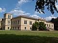 Chateau
 -
 Lookout tower in the chateau park
 -
 Church of St John the Baptist


References
- ^ "Population of Municipalities – 1 January 2020". Czech Statistical Office. 2020-04-30.
Wikimedia Commons has media related to Čechy pod Kosířem.
| Authority control databases: National |
|---|
This Olomouc Region location article is a stub. You can help Wikipedia by expanding it. |