Mérignac, Gironde
Appearance
Mérignac | |
|---|---|
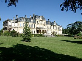
 Castle of Bourran | |
| Coordinates: 44°50′19″N 0°38′37″W / 44.8386°N 0.6436°W | |
| Country | France |
| Region | Nouvelle-Aquitaine |
| Department | Gironde |
| Arrondissement | Bordeaux |
| Canton | Mérignac-1 and 2 |
| Intercommunality | Bordeaux Métropole |
| Government | |
| • Mayor (2020–2026) | Alain Anziani (PS) |
Area 1 | 48.17 km2 (18.60 sq mi) |
| Population (2021)[1] | 75,729 |
| • Density | 1,600/km2 (4,100/sq mi) |
| Time zone | UTC+01:00 (CET) |
| • Summer (DST) | UTC+02:00 (CEST) |
| INSEE/Postal code | 33281 /33700 |
| Elevation | 12–53 m (39–174 ft) |
| 1 French Land Register data, which excludes lakes, ponds, glaciers > 1 km2 (0.386 sq mi or 247 acres) and river estuaries. | |
Mérignac (French pronunciation: [meʁiɲak]) is a commune in the Gironde department in Nouvelle-Aquitaine in southwestern France. The 20th-century historian Robert Étienne (1921–2009) was born in Mérignac.
It is the largest suburb of the city of Bordeaux and adjoins it to the west. It is a member of the Bordeaux Métropole.
Mérignac is the site of Bordeaux International Airport.
Etymology
The name Mérignac derives from the Gallo-Roman word Matriniacus, name of a villa rustica (countryside villa) that was the origin of today's town.
Population
|
|
Sights
- Tour de Veyrines : Veyrines Dungeon.
- Château Bourran : Bourran Castle
- Château Le Burck : Le Burck Castle
- Château or Maison Noble du Parc or d'Espagne : Parc Castle or Spain Castle
- Fontaine d'Arlac : Arlac Fountain
- Immeuble Gillet : Gillet Building
- La glacière : the icehouse
- La vieille église : the old Roman church
- Maison carrée d'Arlac : Peychotte's folly (Square House) in Arlac
Parks and gardens
- Parc de Bourran :
- Bois du Burck : Burck wood
- Parc de Mérignac :
- Parc Saint-Exupéry :
- Parc du Vivier : the wood around the city hall
Education
The commune has about 5,000 students in the primary and secondary schools in its city. Schools include:[2]
- 15 public and private preschools[3]
- 15 public and private elementary schools[4]
- Four junior high schools: Collège de Bourran, Collège de Capeyron, Collège Jules-Ferry, Collège des Eyquems[5]
- Two senior high schools: Lycée Fernand Daguin and Lycée professionnel Marcel Dassault[6]
Twin towns – sister cities
 Saint-Laurent, Quebec, Canada
 Kaolack, Senegal
 Vilanova i la Geltrú, Spain
See also
Notable inhabitants
- Albert Dupouy (1901 - 1973): player of rugby to death in Mérignac
- Jean Samazeuilh (1891 - 1965): French tennis player dead in Mérignac
- Nicolas Canteloup, born on November 4, 1963 in Mérignac in the Gironde, is a comedian, French imitator.
- Émile Rummelhardt former professional player and French football coach.
References
- ^ "Populations légales 2021" (in French). The National Institute of Statistics and Economic Studies. 28 December 2023.
- ^ "Scolarité des 3 – 11 ans." Mérignac, Gironde. Retrieved on September 6, 2016. "Quelque 5 000 enfants sont scolarisés dans la ville."
- ^ "Ecoles maternelles." Mérignac, Gironde. Retrieved on September 6, 2016. "La ville compte une quinzaine d’écoles maternelles, publiques et privées[...]"
- ^ "Ecoles élémentaires." Mérignac, Gironde. Retrieved on September 6, 2016. "La ville compte une quinzaine d’écoles élémentaires, publiques et privées,[..."
- ^ "Collèges." Mérignac, Gironde. Retrieved on September 6, 2016.
- ^ "Lycées." Mérignac, Gironde. Retrieved on September 6, 2016.
- ^ "Relations Internationales". merignac.com (in French). Mérignac. Retrieved 2019-11-19.
External links
Wikimedia Commons has media related to Mérignac, Gironde.
- Official website (in French)
- Official website (in French) (Archive)


