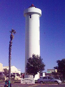
Milnerton Lighthouse
Appearance
 Milnerton Lighthouse | |
 | |
| Location | Milnerton[1][2] Western Cape South Africa |
|---|---|
| Coordinates | 33°52′54.1″S 18°29′16.1″E / 33.881694°S 18.487806°E |
| Tower | |
| Constructed | 1960[1][2] |
| Construction | concrete tower [1][2] |
| Height | 21 metres (69 ft)[1][2] |
| Shape | cylindrical with balcony and small lantern[1][2] |
| Markings | white tower, red lantern roof[1] |
| Light | |
| First lit | 10 March 1960 |
| Focal height | 38 metres (125 ft)[1] |
| Intensity | 800,000 cd[1][2] |
| Range | 25 nautical miles (46 km; 29 mi)[1] |
| Characteristic | Fl (3) W 20s.[2] |
The Milnerton Lighthouse, commissioned on 1960-03-10, is located on Table Bay shore in Milnerton, South Africa.[2] Its red sector covers Robben Island.[2]
See also
References
- ^ a b c d e f g h i j Lighthouses of South Africa. Portnet. 1991. p. 6. ISBN 0-620-16367-4.
- ^ a b c d e f g h i j Williams, Harold A. (1993). Southern lights: lighthouses of Southern Africa. Rivonia: William Waterman publications. p. 130. ISBN 0-9583751-1-9.
- ^ Milnerton The Lighthouse Directory. University of North Carolina at Chapel Hill. Retrieved March 22, 2016
- ^ Milnerton (Table Bay) Light ARLHS SAF-017, Amateur Radio Lighthouse Society (2008-05-12)
External links
- Milnerton Light, Lighthouse Depot
- Milnerton, Lighthouses of South Africa
Wikimedia Commons has media related to Milnerton Lighthouse.
