
Amidon, North Dakota
Amidon, North Dakota | |
|---|---|
 Original Slope County Courthouse in Amidon | |
 Location of Amidon, North Dakota | |
| Country | United States |
| State | North Dakota |
| County | Slope |
| Area | |
| • Total | 0.64 sq mi (1.66 km2) |
| • Land | 0.64 sq mi (1.66 km2) |
| • Water | 0 sq mi (0 km2) |
| Elevation | 2,904 ft (885 m) |
| Population | |
| • Total | 20 |
| • Estimate (2011[3]) | 20 |
| • Density | 31.3/sq mi (12.1/km2) |
| Time zone | UTC-7 (Mountain (MST)) |
| • Summer (DST) | UTC-6 (MDT) |
| ZIP code | 58620 |
| Area code | 701 |
| FIPS code | 38-02060Template:GR |
| GNIS feature ID | 1034682Template:GR |
Amidon ( /ˈæmɪdɒn/ AM-i-don) is a city in Slope County, North Dakota in the United States. It is the county seat of Slope County.Template:GR The population was 20 at the 2010 census, making it the third least populous county seat in the United States, behind Mentone, Texas (population 19), the county seat of Loving County and Brewster, Nebraska (population 17), the county seat of Blaine County, Nebraska.[4]
Located on US 85 about 31 miles (50 km) north of Bowman, North Dakota, it is the closest city to White Butte.
Namesake
Amidon is named after judge Charles F. Amidon.[5]
History
Amidon was founded in 1910 at the anticipated terminus of a Milwaukee Road branch line that diverged from the railroad's Pacific Extension in McLaughlin, South Dakota. The line was ultimately never built farther west of New England, North Dakota, making Amidon one of the few surviving North Dakota cities to have never been served by a rail line.[6]
Geography
Amidon is located at 46°28′59″N 103°19′20″W / 46.48306°N 103.32222°W (46.483042, -103.322251)Template:GR.
According to the United States Census Bureau, the city has a total area of 0.64 square miles (1.66 km2), all of it land.[1]
Demographics
| Census | Pop. | Note | %± |
|---|---|---|---|
| 1920 | 145 | — | |
| 1930 | 141 | −2.8% | |
| 1940 | 102 | −27.7% | |
| 1950 | 82 | −19.6% | |
| 1960 | 84 | 2.4% | |
| 1970 | 54 | −35.7% | |
| 1980 | 43 | −20.4% | |
| 1990 | 24 | −44.2% | |
| 2000 | 26 | 8.3% | |
| 2010 | 20 | −23.1% | |
| 2011 (est.) | 20 | 0.0% | |
2011 estimate | |||
2010 census
As of the census[2] of 2010, there were 20 people, 11 households, and 7 families residing in the city. The population density was 31.3 inhabitants per square mile (12.1/km2). There were 17 housing units at an average density of 26.6 per square mile (10.3/km2). The racial makeup of the city was 100.0% White.
There were 11 households out of which 9.1% had children under the age of 18 living with them, 63.6% were married couples living together, and 36.4% were non-families. 36.4% of all households were made up of individuals and 27.3% had someone living alone who was 65 years of age or older. The average household size was 1.82 and the average family size was 2.29.
The median age in the city was 64 years. 10% of residents were under the age of 18; 0.0% were between the ages of 18 and 24; 15% were from 25 to 44; 25% were from 45 to 64; and 50% were 65 years of age or older. The gender makeup of the city was 50.0% male and 50.0% female.
2000 census
As of the censusTemplate:GR of 2000, there were 26 people, 14 households, and 9 families residing in the city. The population density was 41.2 people per square mile (15.9/km²). There were 17 housing units at an average density of 26.9 per square mile (10.4/km²). The racial makeup of the city was 100.00% White.
There were 14 households out of which 14.3% had children under the age of 18 living with them, 57.1% were married couples living together, 7.1% had a female householder with no husband present, and 35.7% were non-families. 35.7% of all households were made up of individuals and 28.6% had someone living alone who was 65 years of age or older. The average household size was 1.86 and the average family size was 2.33.
In the city the population was spread out with 15.4% under the age of 18, 19.2% from 25 to 44, 38.5% from 45 to 64, and 26.9% who were 65 years of age or older. The median age was 50 years. For every 100 females there were 85.7 males. For every 100 females age 18 and over, there were 83.3 males.
The median income for a household in the city was $27,188, and the median income for a family was $31,250. Males had a median income of $36,250 versus $16,250 for females. The per capita income for the city was $18,765. None of the population and none of the families were below the poverty line.
References
- ^ a b "US Gazetteer files 2010". United States Census Bureau. Retrieved 2012-06-14.
{{cite web}}: External link in|publisher= - ^ a b "American FactFinder". United States Census Bureau. Retrieved 2012-06-14.
{{cite web}}: External link in|publisher= - ^ "Population Estimates". United States Census Bureau. Retrieved 2013-01-04.
{{cite web}}: External link in|publisher= - ^ "2010 Census Redistricting Data (Public Law 94-171) Summary File". American FactFinder. United States Census Bureau. Retrieved 2 May 2011.
- ^ http://www.epodunk.com/cgi-bin/genInfo.php?locIndex=52746
- ^ Wick, Douglas A. "Amidon (Slope County)". North Dakota Place Names. Retrieved 8 May 2011.
External links
Municipalities and communities of Slope County, North Dakota, United States | ||
|---|---|---|
| Cities | 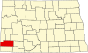 | |
| Unincorporated communities |
| |