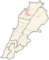
Ardeh, Lebanon
Ardeh
أرده | |
|---|---|
Village | |
 | |
| Country | |
| Governorate | North Governorate |
| District | Zgharta District |
| Elevation | 150 m (490 ft) |
| Time zone | UTC+2 (EET) |
| • Summer (DST) | UTC+3 (EEST) |
| Dialing code | +961 |
Ardeh is a village in Zgharta District, in the Northern Governorate of Lebanon. Ardeh (also known in pre Christian times as Ardata).
It is an ancient and historic town that was known during the 14th century B.C. as "Ardata".
The "Tal" (hill) of Ardeh is an artificial one enfolding ruins of ancient edifices. During the 1970s the Lebanese Directorate of Archeology started archeological diggings in Ardeh and discovered important artifacts.
In 1519 there were 38 adult males living in Ardeh (22 Christians and 16 Muslims) and in 1571 they increased to 62 adult males (44 Christians and 18 Muslims), in 1849 it counted 139 males living in 44 houses. During the early 20th century, Ardeh was inhabited by 150 Maronite males, 20 Orthodox males and 15 Muslim males. In the 1932 census, there were 147 houses in Ardeh.
Location
The village is 84 km from Beirut, 10 km from Tripoli and 4 km from Zgharta.
Elevation
150 metres
Population
Ardeh's official citizens records counted 2616 registered persons in 1998. Nearly one third of the registered persons are now living abroad as emigrants. 160 of the registered are emigrants that had cut their relations with their motherland although their names are still in the records.
Harf Ardeh
A community that shares some of the families with Ardeh. The number of registered in this community has increased significally in the past 4 decades because many persons moved in from the District of Dannieh. In 1998 there were 1220 registered persons (963 registered in 1988), 30% of them are emigrants.
Agriculture
Olives, oranges, grapes, tobacco, fruits and vegetables are grown in the area.
Water sources
- El Kadi spring
- Ain Ardeh
Religious feasts celebrated
- St Rita
- Mar Jirjis [Saint George] – 23 April
- Mar Semman [Saint Simon of the Stylite] – 1 September
- Mar Sarkis and Bakhos – 7 October
- Virgin Marie festival on August 15
Useful Information
Education
The school in Ardeh was present before World War I and teaching was done by the priests. Among them were Yowakim Fadlallah, Youssef Shedid and Elias Awkar. In the 1930s, the Lazarists assisted the school. In 1947, the school became and still sponsored by the Maronite Archdiocese. Today there are 12 teachers and 300 students in this elementary and complementary school. The government opened a public school in 1960, it is still active today.
Families
- Saliba
- Abboud
- Akari
- Amine
- Aoun
- Arab
- Ayash
- Azar
- Badawi
- Badra
- Bechara
- Bou Dib
- Wehbe
- Boulos
- Bourji
- Chahine
- Chahoud
- Chami
- Dib
- jabbour
- Doumit
- Eid
- Fadlallah
- Farah
- bou Fransice
- Ghaleb
- Hadidi
- Hajj
- Hanna
- Haykal
- Helou
- Jabbour
- Kanaan
- Kamel
- Khattar
- Khoury
- Lattouf
- Maatouk
- Mahfoud
- Mardini
- Marroun
- Mazraani
- Moawad
- Moukhtafi
- Naoum
- Nassour
- Nassif
- Nouhra
- Rawdah
- Rezzi
- Saab
- Saad
- Sadek
- Saghir
- Shdid
- Tadros
- Tawni
- Yarake
- Chedid
Administration
The municipality of 15 members is shared with Harf Ardeh and two small communities Beit Awkar and Beit Obeid. The seats are distributed according to the number of listed voters: Ardeh 9 seats, Harf Ardeh 4 seats, Beit Awkar 1 seat, Beit Obeid 1 seat.
External links
- Ardeh - Harf Arden - Beit Okar - Beit Abid, Localiban

