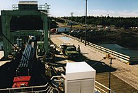
Blacks Harbour, New Brunswick
Blacks Harbour | |
|---|---|
| Coordinates: 45°03′32″N 66°47′05″W / 45.05889°N 66.78472°W | |
| Country | Canada |
| Province | New Brunswick |
| County | Charlotte |
| Municipality | Eastern Charlotte |
| Incorporated | 1972 |
| Amalgamated | 1 January 2023 |
| Area | |
| • Total | 9.02 km2 (3.48 sq mi) |
| Population (2021)[1] | |
| • Total | 907 |
| • Density | 100.6/km2 (261/sq mi) |
| • Pop 2016-2021 | |
| • Dwellings | 421 |
| Time zone | UTC-4 (AST) |
| • Summer (DST) | UTC-3 (ADT) |
| Postal code(s) | |
| Area code | 506 |
| Highways | |
| Website | www.blacksharbour.ca/ home_page.html |
Blacks Harbour is a community in the rural community of Eastern Charlotte, New Brunswick, Canada. It held village status prior to 2023. It is on a harbour of the same name opening onto the Bay of Fundy. It is 15 kilometres southeast of the town of St. George, 3 kilometres west of Beaver Harbour and 56 kilometres east from the town of St. Stephen on Route 176.
History[edit]
Blacks Harbour's exact origin is unknown, possibly an early family name. Post office dates from 1889.[2]
On 1 January 2023, Blacks Harbour amalgamated with St. George and all or part of five local service districts to form the new incorporated rural community of Eastern Charlotte.[3][4] The name Blacks Harbour remains in official use.[5]
Geography[edit]

Blacks Harbour is the northern terminus for the year-round Blacks Harbour to Grand Manan Island Ferry operated by Coastal Transport
Fishing has been a vital part of its existence for over 200 years. Connors Brothers Limited was founded in 1885 at Blacks Harbour, now a major international processor of all types of seafood. The company is also a major New Brunswick employer.
Demographics[edit]
In the 2021 Census of Population conducted by Statistics Canada, Blacks Harbour had a population of 907 living in 385 of its 421 total private dwellings, a change of 1.5% from its 2016 population of 894. With a land area of 9.02 km2 (3.48 sq mi), it had a population density of 100.6/km2 (260.4/sq mi) in 2021.[1]
| 2021 | 2011 | |
|---|---|---|
| Population | 907 (+1.5% from 2016) | 982 (+3.2% from 2006) |
| Land area | 9.02 km2 (3.48 sq mi) | 8.90 km2 (3.44 sq mi) |
| Population density | 100.6/km2 (261/sq mi) | 110.3/km2 (286/sq mi) |
| Median age | 45.6 (M: 44.4, F: 46.8) | 42.5 (M: 40.2, F: 45.0) |
| Private dwellings | 421 (total) 385 (occupied) | 417 (total) |
| Median household income | $60,000 | $43,367 |
Language[edit]
| Canada Census Mother Tongue - Blacks Harbour, New Brunswick[6] | ||||||||||||||||||
|---|---|---|---|---|---|---|---|---|---|---|---|---|---|---|---|---|---|---|
| Census | Total | English
|
French
|
English & French
|
Other
| |||||||||||||
| Year | Responses | Count | Trend | Pop % | Count | Trend | Pop % | Count | Trend | Pop % | Count | Trend | Pop % | |||||
2011
|
950
|
850 | 89.47% | 65 | 6.84% | 5 | 0.53% | 30 | 3.16% | |||||||||
2006
|
930
|
835 | 89.79% | 80 | 8.60% | 0 | 0.00% | 15 | 1.61% | |||||||||
2001
|
1,065
|
965 | 90.61% | 100 | 9.39% | 0 | 0.00% | 0 | 0.00% | |||||||||
1996
|
1,135
|
975 | n/a | 85.90% | 105 | n/a | 9.25% | 10 | n/a | 0.88% | 45 | n/a | 3.96% | |||||
References[edit]
- ^ a b c d "Population and dwelling counts: Canada, provinces and territories, census divisions and census subdivisions (municipalities), New Brunswick". Statistics Canada. 9 February 2022. Retrieved 21 February 2022.
- ^ Hamilton, William (1978). The Macmillan Book of Canadian Place Names. Toronto: Macmillan. p. 71. ISBN 0-7715-9754-1.
- ^ "Local Governments Establishment Regulation – Local Governance Act". Government of New Brunswick. 12 October 2022. Retrieved 20 January 2023.
- ^ "RSC 10 Southwest Regional Service Commission". Government of New Brunswick. Retrieved 20 January 2023.
- ^ "Proposed entity names reflect strong ties to nature and history" (Press release). Irishtown, New Brunswick: Government of New Brunswick. 25 May 2022. Retrieved 20 January 2023.
- ^ a b Statistics Canada: 1996, 2001, 2006, 2011 census
- ^ "2021 Community Profiles". 2021 Canadian Census. Statistics Canada. 4 February 2022. Retrieved 19 October 2023.
- ^ "2011 Community Profiles". 2011 Canadian Census. Statistics Canada. 21 March 2019. Retrieved 19 May 2014.
- ^ "2006 Community Profiles". 2006 Canadian Census. Statistics Canada. 20 August 2019.
- ^ "2001 Community Profiles". 2001 Canadian Census. Statistics Canada. 18 July 2021.

