
Boulder Park

Boulder Park National Natural Landmark along with the nearby Natural Landmarks McNeil Canyon Haystack Rocks and Sims Corner Eskers and Kames comprise several of the best examples of Pleistocene ice stagnation landforms in Washington. Features include numerous glacial erratics near and on the terminal moraine. Boulder Park is located on the Waterville Plateau of the Columbia Plateau in north central Washington state in the United States. The boulders provide important evidence for glacial erosion and transport, as well as marking the direction of movement and the terminus of the Okanogan lobe on the southern margin of the Cordilleran ice sheet during the last glaciation.[1]
See also
References
- ^ Mueller, Marge & Ted (1997). Fire, Faults and Floods. University of Idaho Press, Moscow, Idaho. ISBN 0-89301-206-8.
External links
Photo gallery
-
-
 A kame among the glacial drift on the terminal moraine.
 -
 Terminal moraine (Withrow Moraine) of the Okanagon Lobe
 -
 Multiple erratics on the terminal moraine of the Okanagon Lobe. Cascade mountains in the background.
 -
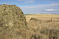
 Multiple erratics on the terminal moraine of the Okanagon Lobe.


| Ice Age Glacial Floods |  | |
|---|---|---|
| Glacial Lakes | ||
| Temporary Lakes | ||
| Ice Age Floods Glacial Residue | ||
| Ice Age Floods Erosion & Deposition Features | ||
| Related contemporaneous events | ||