Bowling Green station
Bowling Green | |||||||||||
|---|---|---|---|---|---|---|---|---|---|---|---|
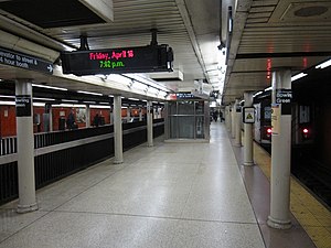
 Platform for trains going to Brooklyn (right) | |||||||||||
| Station statistics | |||||||||||
| Address | Battery Place & Broadway New York, NY 10004 | ||||||||||
| Borough | Manhattan | ||||||||||
| Locale | Financial District | ||||||||||
| Division | A (IRT)[1] | ||||||||||
| Line | IRT Lexington Avenue Line | ||||||||||
| Services | 4 5 | ||||||||||
| Transit | |||||||||||
| Structure | Underground | ||||||||||
| Platforms | 1 side platform 2 island platforms (1 in use, 1 abandoned) | ||||||||||
| Tracks | 2 | ||||||||||
| Other information | |||||||||||
| Opened | July 10, 1905 | ||||||||||
| Accessible | |||||||||||
| Opposite- direction transfer | Yes | ||||||||||
| Traffic | |||||||||||
| 2023 | 4,575,586[2] | ||||||||||
| Rank | 60 out of 423[2] | ||||||||||
| Station succession | |||||||||||
| Next north | Template:NYCS next | ||||||||||
| Next south | Template:NYCS next Template:NYCS next South Ferry (closed) | ||||||||||
| |||||||||||
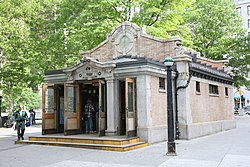
Battery Park Control House | |||||||||||
 Station headhouse on Battery Park dates to 1905 | |||||||||||
| Coordinates | 40°42′15″N 74°00′52″W / 40.704106°N 74.014521°W | ||||||||||
| Built | 1905 | ||||||||||
| Architect | Heins & LaFarge | ||||||||||
| MPS | Interborough Rapid Transit Subway Control Houses TR | ||||||||||
| NRHP reference No. | 80002669 | ||||||||||
| Added to NRHP | May 6, 1980[3] | ||||||||||
Bowling Green is a station on the IRT Lexington Avenue Line of the New York City Subway, located at Broadway and Battery Place (at the Bowling Green), in the Financial District of Manhattan. It is served by the 4 train at all times and the 5 train at all times except late nights.
Station layout
| G | Street Level | Exit/Entrance |
| P Platform level |
Side platform, doors will open on the right | |
| Northbound | ← ← | |
| Island platform, doors will open on the left for southbound trains only | ||
| Southbound | → → → | |
| Island platform, not in service, fits 3 cars | ||
| Shuttle | → No passenger service (No service: South Ferry loops) | |
| M | Mezzanine | Fare control, station agent |
Track layout | ||||||||||||||||||||||||||||||||||||||||||||||||||||||||||||||||||||||||||||||||||||||||||||||||||||||||||||||||||||||||||||||||||||||||||||
|---|---|---|---|---|---|---|---|---|---|---|---|---|---|---|---|---|---|---|---|---|---|---|---|---|---|---|---|---|---|---|---|---|---|---|---|---|---|---|---|---|---|---|---|---|---|---|---|---|---|---|---|---|---|---|---|---|---|---|---|---|---|---|---|---|---|---|---|---|---|---|---|---|---|---|---|---|---|---|---|---|---|---|---|---|---|---|---|---|---|---|---|---|---|---|---|---|---|---|---|---|---|---|---|---|---|---|---|---|---|---|---|---|---|---|---|---|---|---|---|---|---|---|---|---|---|---|---|---|---|---|---|---|---|---|---|---|---|---|---|---|
| ||||||||||||||||||||||||||||||||||||||||||||||||||||||||||||||||||||||||||||||||||||||||||||||||||||||||||||||||||||||||||||||||||||||||||||
| ||||||||||||||||||||||||||||||||||||||||||||||||||||||||||||||||||||||||||||||||||||||||||||||||||||||||||||||||||||||||||||||||||||||||||||
The station has two tracks and two platforms in service: a center island platform that serves Brooklyn-bound trains, and a side platform that serves uptown trains. An abandoned and walled off island platform and track on the west side of the station were formerly used by the Bowling Green – South Ferry Shuttle to the inner platform at South Ferry. South of the station, the tracks diverge with one set entering the Joralemon Street Tunnel to Brooklyn. The line continues to the closed South Ferry inner loop station, which is used by the 5 train when it short turns at Bowling Green during evenings and weekends.
History
When the station opened on July 10, 1905, there was as yet no IRT service to Brooklyn, and all Lexington Avenue trains terminated at South Ferry, using the outer-loop platform.[5] After the Joralemon Street Tunnel opened in 1908, some Lexington Avenue trains continued to terminate at South Ferry, even during rush hours, while others went to Brooklyn. This service pattern was soon found to be inadequate for the high volume of Brooklyn riders.
Just three months after the Joralemon Tunnel opened, construction began on the third track and the western island platform at Bowling Green. Once they were completed in 1909, all rush-hour trains were sent to Brooklyn, with a two-car Bowling Green – South Ferry Shuttle train providing service to South Ferry during those times. Even after the IRT Broadway – Seventh Avenue Line local service (1 train) began to South Ferry in 1918, the shuttle remained in operation until it was discontinued in 1977 due to budget cuts.[6] The shuttle platform was renovated in 1978 along with the rest of the station. The 1978 renovation covered over the original Heins & LaFarge mosaic "tapestries" that were along the walls.
The 1970s renovation also led to the construction of the eastern side platform, again due to high passenger volume on the island platform. Additional exits were requested and an underpass was built, funneling some of the traffic away from the headhouse exit at the south end. This led to the station's current configuration, with uptown trains using the side platform, and Brooklyn-bound trains using the island platform (similar to the configuration at Broadway Junction on the BMT Canarsie Line). A fence is located along the edge of the island platform, preventing northbound trains from releasing passengers onto the island platform. The fare control now consists of the restored headhouse entrance at the south end, which serves only the island platform, and various other entrances that lead to the eastern side platform and down to a large fare control area in the underpass.
Two elevators make the station ADA-accessible. One connects street level with the fare control area below the platforms and tracks with an intermediate stop at the main northbound fare control area while the other connects the Brooklyn-bound platform with the fare control area below.
The station's usage as both a terminal station and a through station is still an issue today, in that 5 trains short turn at Bowling Green after about 8 p.m. on weeknights, and do not run into Brooklyn on weekends. This causes a bottleneck on the Lexington Avenue Line, as southbound 4 trains must wait at Wall Street for at least 3 minutes to allow 5 trains to be emptied of passengers here.
Control House
The station's head house, known as the Bowling Green IRT Control House or Battery Park Control House, is located near the southern end of Broadway. This subway entrance was designed by Heins & LaFarge and built in 1905 on the west side of State Street, across from the Alexander Hamilton U.S. Custom House.[7]
Along with its twin, the old control house for the 72nd Street station, this building is a reminder of the glory of New York's first subway company, the Interborough Rapid Transit Company, predecessor to the current numbered routes. Although most of the original subway's entry points had steel and glass kiosks (for example, Astor Place), important stations like this one were marked with a brick and stone control house, called such as they helped control the passenger flow. It is listed on the National Register of Historic Places.
Artwork
The Bowling Green station has lightboxes with rotating content. The current exhibition, since April 2015, is "Breaking Ground", featuring pictures taken by Patrick J. Cashin of MTA Capital Construction projects such as the 7 Subway Extension, Second Avenue Subway, and East Side Access. Some of these photos can be seen on the MTA's Flickr account as well.[8]
Image gallery
-
The orange tiles on the walls date to the 1970s
-
Former shuttle platform on the Brooklyn-bound side
-
Entrance in Bowling Green
-
Entrance in anticipation of Hurricane Sandy
References
- ^ "Glossary". Second Avenue Subway Supplemental Draft Environmental Impact Statement (SDEIS) (PDF). Vol. 1. Metropolitan Transportation Authority. March 4, 2003. pp. 1–2. Archived from the original (PDF) on February 26, 2021. Retrieved January 1, 2021.
- ^ a b "Annual Subway Ridership (2018–2023)". Metropolitan Transportation Authority. 2023. Retrieved April 20, 2024.
- ^ "National Register Information System". National Register of Historic Places. National Park Service. March 13, 2009.
- ^ "Facts and Figures: Annual Subway Ridership". Metropolitan Transportation Authority. Retrieved 2016-04-19.
- ^ "SUBWAY TRAINS RUNNING FROM BRONX TO BATTERY; West Farms and South Ferry Stations Open at Midnight. START WITHOUT A HITCH Bowling Green Station Also Opened -- Lenox Avenue Locals Take City Hall Loop Hereafter". Retrieved 2016-09-04.
- ^ Blumenthal, Ralph (1977-01-15). "Transit Cuts Approved by M.T.A.; Reductions Will Begin Next Month". New York Times. Retrieved 2010-03-03.
- ^ Framberger, David J. "Architectural Designs For New York's First Subway". Survey Number HAER NY-122, pp. 365-412. National Park Service Department of the Interior Washington, DC. 20240. Retrieved 26 December 2010.
- ^ "New Photography Exhibit Tracks Progress of MTA Capital Projects". mta.info. 10 April 2015. Retrieved 13 April 2015.
Further reading
- Lee Stokey. Subway Ceramics : A History and Iconography. 1994. ISBN 978-0-9635486-1-0
External links
- nycsubway.org – IRT East Side Line: Bowling Green
- nycsubway.org — The Essence of Time Artwork by Nicole Bengiveno (2007)
- nycsubway.org — A Way To Go Artwork by Zach DeSart (2009)
- Station Reporter — 4 Train
- Station Reporter — 5 Train
- Abandoned Stations — Bowling Green & South Ferry platforms
- Battery Place and Broadway / State Street entrance from Google Maps Street View
- Bowling Green entrance from Google Maps Street View
- Control house from Google Maps Street View
- Platforms from Google Maps Street View
- Accessible New York City Subway stations
- Heins and LaFarge buildings
- IRT Lexington Avenue Line stations
- Landmarks in Manhattan
- Railway and subway stations on the National Register of Historic Places in Manhattan
- New York City Subway stations in Manhattan
- Railway stations opened in 1905
- Broadway (Manhattan)
- Financial District, Manhattan


