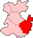
Bridgnorth District
| Bridgnorth District | |
|---|---|
 Shown within Shropshire non-metropolitan county | |
| History | |
| • Origin | Bridgnorth Rural District Much Wenlock Municipal Borough Shifnal Rural District (part) |
| • Created | 1974 |
| • Abolished | 2009 |
| • Succeeded by | Shropshire |
| Status | District |
| ONS code | 39UB |
| Government | Bridgnorth District Council |
| • HQ | Bridgnorth |
Bridgnorth District was, between 1974 and 2009, a local government district in Shropshire, England. Its main town was Bridgnorth and other towns in its area were Much Wenlock, Shifnal and Broseley. The villages of Albrighton and Sheriffhales as well as RAF Cosford were also in the district.
The district was formed on 1 April 1974, under the Local Government Act 1972. It was a merger of the Bridgnorth Rural District, Much Wenlock Municipal Borough and nearly all of the Shifnal Rural District.
The district was administered by Bridgnorth District Council until abolition on 1 April 2009 when the new Shropshire unitary authority was established as part of the 2009 structural changes to local government in England.
Energy policy
In May 2006, a report commissioned by British Gas [1] showed that housing in the district of Bridgnorth produced the 12th highest average carbon emissions in the country at 7,176 kg of carbon dioxide per dwelling.


