Carlynton School District
| Carlynton School District | |
|---|---|
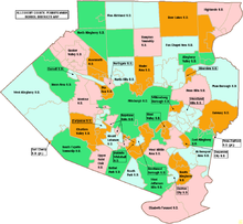
 Carlynton School District, light blue, is shown at the left of center, just west of Pittsburgh, green. | |
| Address | |
435 King's Highway
Carnegie , Allegheny, Pennsylvania, 15106United States | |
| District information | |
| Type | Public |
| Grades | K-12 |
| Students and staff | |
| Athletic conference | WPIAL Class = 2A |
| District mascot | The Mighty Golden Cougars |
| Colors | Green and Gold |
| Other information | |
| Website | http://www.carlynton.k12.pa.us/ |
The Carlynton School District is a small, suburban, public school district located approximately six miles west of downtown Pittsburgh, Pennsylvania. The district covers five square miles, including the Boroughs of Carnegie, Crafton and Rosslyn Farms. From these communities comes the name Carlynton (Carnegie, Rosslyn Farms and Crafton). According to 2000 federal census data, it serves a resident population of 15,559. In 2009, the district residents' per capita income was $22,323, while the median family income was $46,345.[1]
References[edit]
- ^ American Fact Finder, US Census Bureau, 2009
