
Central, Minneapolis

Central | |
|---|---|
 Location of Central within the U.S. city of Minneapolis | |
| Country | United States |
| State | Minnesota |
| County | Hennepin |
| City | Minneapolis |
| Neighborhoods | |
| Area | |
| • Total | 3.024 sq mi (7.83 km2) |
| Population (2017)[2] | |
| • Total | 43,456 |
| • Density | 14,000/sq mi (5,500/km2) |
| Time zone | UTC-6 (CST) |
| • Summer (DST) | UTC-5 (CDT) |
| ZIP code | 55401, 55402, 55403, 55404, 55405, 55411, 55415, 55454, 55487 |
| Area code | 612 |
| Census | Pop. | Note | %± |
|---|---|---|---|
| 1980 | 18,952 | — | |
| 1990 | 21,158 | 11.6% | |
| 2000 | 24,149 | 14.1% | |
| 2010 | 29,725 | 23.1% |
The Central community in Minneapolis is located in the central part of the city, consisting of 6 smaller official neighborhoods, and includes Downtown Minneapolis, the central business district. It also includes some high-density residential areas surrounding it, excluding areas east of the Mississippi River.
Official neighborhoods in the Central community
- Downtown East
- Downtown West where most of the high-rise office buildings are located
- Elliot Park
- Loring Park
- North Loop commonly referred to as the Warehouse District
- Stevens Square/Loring Heights
44°58′35″N 93°16′26″W / 44.9763°N 93.2739°W[3]
Gallery
-
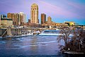 View of downtown Minneapolis from the Stone_Arch_Bridge_(Minneapolis).
 -
 Downtown Minneapolis Panorama
 -
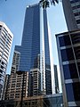 White U.S. Bancorp towers reflected in the Capella Tower.
 -
 Downtown Minneapolis from Lake Calhoun.
 -
 Minneapolis Skyline from Target Field.
 -
-
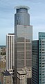
 Wells Fargo Center from the Foshay Tower
 -

-
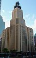
 The Foshay Tower
 -
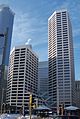
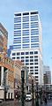
 33 South Sixth, also known as the City Center.
 -
 Target Plaza South, the headquarters of Target Corporation, lit up multicolored during the winter.
 -
 The Carlyle, the tallest residential building in Minneapolis.
 -

-
-
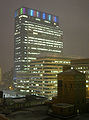
 The Hennepin County Government Center, the site of the Occupy Minnesota protests.
 -
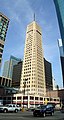
 The CenturyLink Building, the 17th tallest building in Minneapolis.
 -
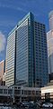
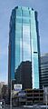
 US Bank Plaza, the 6th tallest building in Minneapolis.
 -

-
-

-


See also
References
Wikivoyage has a travel guide for Downtown Minneapolis.
- ^ "Greater Central neighborhood in Minneapolis, Minnesota (MN), 55401, 55402, 55403, 55404, 55415 detailed profile". City-Data. 2011. Retrieved 2013-11-12.
- ^ "Minneapolis Community Profile: Central" (PDF). Minnesota Compass. October 2011. Retrieved 2013-11-12.
- ^ Central, Minneapolis, MN. Google Earth. Retrieved 2011-03-09.