
Chōkai Sanroku Line
| Chōkai Sanroku Line | |
|---|---|
 A YR-3000 railcar at Yajima Station | |
| Overview | |
| Status | In operation |
| Owner | Yuri Kōgen Tetsudō |
| Locale | Akita Prefecture |
| Termini | |
| Stations | 12 |
| Service | |
| Type | Heavy rail |
| Operator(s) | Yuri Kōgen Tetsudō |
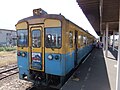
| Rolling stock | YR-2000 DMU, YR-3000 DMU |
| History | |
| Opened | August 1, 1922[1] |
| Technical | |
| Line length | 23.0 km (14.3 mi) |
| Number of tracks | Entire line single tracked |
| Character | Rural |
| Track gauge | 1,067 mm (3 ft 6 in) |
| Electrification | None |
| Operating speed | 65 km/h (40 mph)[2] |
The Chōkai Sanroku Line (鳥海山ろく線, Chōkai Sanroku-sen, "Chōkai Submontane Line") is a Japanese railway line in Akita Prefecture in northern Japan, with all station located within the city of Yurihonjō. This is the only railway line operated by the Yuri Kōgen Railway (由利高原鉄道, Yuri Kōgen Tetsudō).
History[edit]
On August 1, 1922, the privately owned Yokote Railway Company (横手鉄道, Yokote Tetsudō) completed its West Line, connecting Ugo-Honjō with Maegō over 11.6 rail kilometers, and renamed itself the Yokojō Railway Company (横荘鉄道, Yokojō Tetsudō).[1] The line was nationalized on September 1, 1937 becoming the Japanese Government Railway (JGR) Yashima Line (矢島, Yashima sen)[3] and the line was extended by an additional 4.1 kilometers to Nishitakisawa by December 15 of the same year. The line was further extended an additional 7.3 kilometers to its present terminus at Yashima by October 21, 1938.
The JGR became the Japanese National Railways (JNR) after World War II. All scheduled freight services were discontinued from March 10, 1981.[citation needed] In 1985, the operations of the former Yashima Line were taken over by the third sector company Yuri Kōgen Railway.[4]
Proposed connecting line[edit]
- Maego Station - The Yokote Railway Co. opened a 38 km line from Yokote on the Ou Main Line to Oikata between 1918 and 1930. Construction commenced on an extension to this station but it was not completed. The 12 km section from Oikata - Niiyama was closed following typhoon damage in 1947, the 7 km section from Niiyama - Tateai closed in 1965 when a bridge was destroyed by floodwaters, and the balance of the line closed in 1971.
Basic data[edit]
- Distance: 23.0 km (14.3 mi)
- Gauge: 1,067 mm (3 ft 6 in)
- Stations: 12
- Track: Entire line single tracked
- Power: Internal combustion (Diesel)
- Railway signalling
Stations[edit]
| Station | Japanese | Distance between stations (km) |
Distance (km) |
|---|---|---|---|
| Ugo-Honjō | 羽後本荘 | - | 0.0 |
| Yakushidō | 薬師堂 | 2.2 | 2.2 |
| Koyoshi | 子吉 | 2.3 | 4.5 |
| Ayukawa | 鮎川 | 2.9 | 7.4 |
| Kurosawa | 黒沢 | 2.1 | 9.5 |
| Magarisawa | 曲沢 | 0.8 | 10.3 |
| Maegō | 前郷 | 1.4 | 11.7 |
| Kubota | 久保田 | 1.9 | 13.6 |
| Nishitakisawa | 西滝沢 | 2.1 | 15.7 |
| Yoshizawa | 吉沢 | 1.4 | 17.1 |
| Kawabe | 川辺 | 3.0 | 20.1 |
| Yashima | 矢島 | 2.9 | 23.0 |
Rolling stock[edit]
As of August 2020, the line operates the following diesel multiple units (DMUs):
- YR-2000 (total 2 cars)
- YR-3000 (total 3 cars)
-
 YR-2001
 -
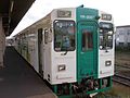 YR-3001


Former rolling stock[edit]
- YR-1000/YR-1500 (total 5 cars)
-
 YR-1501

See also[edit]
References[edit]
This article incorporates material from the corresponding article in the Japanese Wikipedia.
- ^ a b 大蔵省印刷局 (1922). "官報. 1922年08月05日 - 国立国会図書館デジタルコレクション". dl.ndl.go.jp. doi:10.11501/2955122. Retrieved August 27, 2020.
- ^ Terada, Hirokazu (2000). Nihon no rōkaru shitetsu. Tokyo: ネコ・パブリッシング. ISBN 4-87366-207-9. OCLC 676199611.
- ^ 日本国有鉄道百年. Vol. 11. p. 886.
- ^ Bushell, Chris, ed. (2006). Railway Directory 2006 (111th ed.). Reed Business Information. pp. 127, 128. ISBN 0-617-01031-5.
External links[edit]
- Yuri Kōgen Railway official website (in Japanese)
Transit in Akita Prefecture | |
|---|---|
| Akita Nairiku Jūkan Railway | |
| Yuri Kōgen Railway | |
| Named trains | |
| Misc | |