
Chappells, South Carolina
Chappells, South Carolina | |
|---|---|
 Chappells, South Carolina  Chappells, South Carolina | |
| Coordinates: 34°10′47″N 81°52′00″W / 34.17972°N 81.86667°W | |
| Country | United States |
| State | South Carolina |
| County | Newberry |
| Elevation | 436 ft (133 m) |
| Time zone | UTC-5 (Eastern (EST)) |
| • Summer (DST) | UTC-4 (EDT) |
| ZIP code | 29037 |
| Area code | 803 |
| GNIS feature ID | 1247255[1] |
Chappells (also Chappell, Chappells Bridge) is an unincorporated community, in Newberry County, South Carolina, United States.[1]
The Moon-Dominick House and Webb-Coleman House are listed on the National Register of Historic Places.[2]
Notes
Municipalities and communities of Newberry County, South Carolina, United States | ||
|---|---|---|
| City | 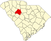 | |
| Towns | ||
| CDP | ||
| Other communities | ||
| Footnotes | ‡This populated place also has portions in an adjacent county or counties | |
This South Carolina state location article is a stub. You can help Wikipedia by expanding it. |