
Chharra, Purulia
Chharra | |
|---|---|
Village | |
 Chharra Location in West Bengal, India  Chharra Chharra (India) | |
| Coordinates: 23°22′55″N 86°25′01″E / 23.3820°N 86.4170°E | |
| Country | |
| State | West Bengal |
| District | Purulia |
| Population (2011) | |
| • Total | 6,131 |
| Languages | |
| • Official | Bengali, English |
| Time zone | UTC+5:30 (IST) |
| PIN | 723163 |
| Telephone/STD code | 03254 |
| Lok Sabha constituency | Purulia |
| Vidhan Sabha constituency | Purulia |
| Website | purulia |
Chharra is a village in the Purulia II CD block in the Purulia Sadar subdivision of the Purulia district in the state of West Bengal, India.
Geography[edit]


5miles
Hills
M: municipality, CT: census town, R: rural/ urban centre, H: historical/ religious centre, F: facility
Owing to space constraints in the small map, the actual locations in a larger map may vary slightly
Location[edit]
Chharra is located at 23°22′55″N 86°25′01″E / 23.3820°N 86.4170°E.
Charra Airfield was used during the World War II and abandoned thereafter.[1]
Area overview[edit]
Purulia district forms the lowest step of the Chota Nagpur Plateau. The general scenario is undulating land with scattered hills. Purulia Sadar subdivision covers the central portion of the district. 83.80% of the population of the subdivision lives in rural areas. The map alongside shows some urbanization around Purulia city. 18.58% of the population, the highest among the subdivisions of the district, lives in urban areas. There are 4 census towns in the subdivision. The Kangsabati (locally called Kansai) flows through the subdivision. The subdivision has old temples, some of them belonging to the 11th century or earlier. The focus is on education - the university, the sainik school, the Ramakrishna Mission Vidyapith at Bongabari, the upcoming medical college at Hatuara, et al.[2][3][4][5][6][7][8][9]
Note: The map alongside presents some of the notable locations in the subdivision. All places marked in the map are linked in the larger full screen map.
Demographics[edit]
According to the 2011 Census of India, Chharra had a total population of 6,131, of which 3,163 (52%) were males and 2,968 (48%) were females. There were 818 persons in the age range of 0–6 years. The total number of literate persons in Chharra was 3,312 (62.34% of the population over 6 years).[10]
Transport[edit]
There is a station at Chharra on the Adra-Purulia sector of the Asansol-Tatanagar-Kharagpur line of the South Eastern Railway.[11]
Education[edit]
Chhara High School is a Bengali-medium coeducational institution established in 1959. It has facilities for teaching from class V to class XII.[12]
Culture[edit]
There is a small rekha deul built of stone in the village. The tower is extensively carved. The ornamentation of the sikhara suggests that it belongs to an age earlier than the Telkupi temples, i.e., earlier than 11th century. There was another temple which has fallen. It was a plain pancha ratna temple. With loose Jain sculptures strewn around the village, it is possible that both were Jain temples.[13]
David J. McCutchion says that in the remote areas of old Manbhum district the Jains went on building temples till the 13th century, and many of them are still standing at Bahulara, Harmasra, Deulbhirya, Ambikanagar, Chharra, Pakbirra, Suisa or Deoli, in Bankura and Purulia districts.[14]
Chharra picture gallery[edit]
-
 The renovated deul
 -
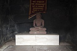 Tirthankar statue
 -
 Back side of stone deul
 -
 Votive temple
 -
 Remains of a Jain temple
 -
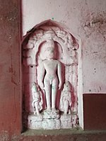 A Jain deity in a Dharmathakur temple


Healthcare[edit]
Kushtor Rural Hospital, with 30 beds, is the major government medical facility in the Purulia II CD block.[15]
References[edit]
- ^ "Bengal govt looking to bring back Chharra airfield in Purulia". millennium post 20 January 2018. 20 January 2018. Retrieved 19 January 2020.
- ^ Houlton, Sir John, Bihar, the Heart of India, 1949, p. 170, Orient Longmans Ltd.
- ^ "District Statistical Handbook 2014 Purulia". Tables 2.1, 2.2. Department of Planning and Statistics, Government of West Bengal. Archived from the original on 21 January 2019. Retrieved 12 January 2020.
- ^ "District Census Handbook, Puruliya, Series 20, Part XII A" (PDF). Deulghat - Pages 99-100: Brief Description of Places of Religious, Historical or Archaeological Importance and Places of Tourist Importance of the District. Directorate of Census Operations, West Bengal. Retrieved 21 January 2020.
- ^ "District Census Handbook, Puruliya, Series 20, Part XII A" (PDF). Charra - Page 103: Brief Description of Places of Religious, Historical or Archaeological Importance and Places of Tourist Importance of the District. Directorate of Census Operations, West Bengal. Retrieved 21 January 2020.
- ^ "Sidho-Kano-Birsha University". SKBU. Retrieved 17 January 2020.[permanent dead link]
- ^ "Sainik School Purulia". SSP. Retrieved 1 February 2020.
- ^ "West Bengal's RKM college bags highest NAAC grade". The Times of India. The Times of India, 16 December 2019. 16 December 2019. Retrieved 31 January 2020.
- ^ "Purulia Government Medical College & Hospital". PGMCH. Archived from the original on 26 October 2020. Retrieved 17 January 2020.
- ^ "C.D. Block Wise Primary Census Abstract Data(PCA)". West Bengal – District-wise CD Blocks. Registrar General and Census Commissioner, India. Retrieved 21 January 2020.
- ^ "63594 Asansol-Purulia MEMU". Time Table. indiarailinfo. Retrieved 21 January 2020.
- ^ "Chhara High School". ICBSE. Retrieved 19 January 2020.
- ^ "District Census Handbook, Puruliya, Series 20, Part XII A" (PDF). Charra - Page 103: Brief Description of Places of Religious, Historical or Archaeological Importance and Places of Tourist Importance of the District. Directorate of Census Operations, West Bengal. Retrieved 21 January 2020.
- ^ McCutchion, David J., Late Mediaeval Temples of Bengal, first published 1972, reprinted 2017, page 2. The Asiatic Society, Kolkata, ISBN 978-93-81574-65-2
- ^ "Health & Family Welfare Department" (PDF). Health Statistics – Rural Hospitals. Government of West Bengal. Archived from the original (PDF) on 8 October 2022. Retrieved 22 January 2020.
