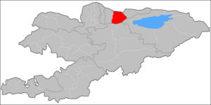
Chüy District
Chuy | |
|---|---|
 | |
| Country | Kyrgyzstan |
| Region | Chuy Region |
| Chuy District | 1927 |
| Seat | Chuy |
| Area | |
| • Total | 1,756 km2 (678 sq mi) |
| Population (2009)[1] | |
| • Total | 47,017 |
| • Density | 27/km2 (69/sq mi) |
| Time zone | UTC+5 (GMT +5) |
Chuy is a raion (district) of Chuy Region in northern Kyrgyzstan. Its area is 1,756 square kilometres (678 sq mi), and its resident population was 47,017 in 2009.[1] The district surrounds the city of Tokmok, but does not include it. The district capital lies at Chuy.[2]
Geography
Chuy District is located in the eastern part of Chuy Valley. Its southern part spreads into Kyrgyz Ala-Too mountains. Chu River and its tributaries Shamshy River, Kegeti River, etc. dominate the hydrology. There are a number of glaciers feeding tributaries in Kyrgyz Ala-Too such as Shamshy Glacier, Kel-Ter, etc. The climate is continental.
Demographics
As of 2009, Chuy District included 38 villages. Its population, according to the Population and Housing Census of 2009, was 47,017.
| Year | Pop. | ±% |
|---|---|---|
| 1970 | 32,710 | — |
| 1979 | 37,094 | +13.4% |
| 1989 | 42,968 | +15.8% |
| 1999 | 44,786 | +4.2% |
| 2009 | 47,017 | +5.0% |
| Source:[1] | ||
Ethnic composition
According to the 2009 Census, the ethnic composition (de jure population) of the Chuy District was:[1]
| Ethnic group | Population | Proportion of Chuy District population |
|---|---|---|
| Kyrgyzs | 39,116 | 83.2% |
| Russians | 3,255 | 6.9% |
| Dungans | 2,201 | 4.7% |
| Azerbaijanis | 828 | 1.8% |
| Kazakhs | 522 | 1.1% |
| Uzbeks | 294 | 0.6% |
| Germans | 152 | 0.3% |
| Tatars | 130 | 0.3% |
| other groups | 519 | 1.1% |
Towns, rural communities, and villages
In total, Chuy District include 10 rural communities (aiyl okmotus). Each rural community can consist of one or several villages. In total, there are 39 villages in Chuy District. The rural communities and settlements in the Chuy District are:[3]
- Ak-Beshim aiyl okmotu (center - village Ak-Beshim, and also villages Jangy-Jol, Kalygul)
- Burana aiyl okmotu (center - village Döng-Aryk, and also villages Alga, Burana, Meenetkech)
- Ibraimov aiyl okmotu (center - village Koshoy, and also villages Kara-Oy, Kyzyl-Asker, Imeni Lenina, Lenin-Jol, Taldy-Bulak)
- Iskra aiyl okmotu (center - village Kara-Döbö, and also villages Vostochnoe, Jangy-Turmush, Iskra, Zheleznodorozhnoye)
- Kegeti aiyl okmotu (center - village Kegeti, and also villages Arpa-Tektir, Akmatbek, Sovetskoye, Imeni Chapayeva)
- Kosh-Korgon aiyl okmotu (center - village Kosh-Korgon)
- On Bir-Jylga aiyl okmotu (center - village Progress, and also villages Onbir-Jylga, Kayyrma, Madaniyat)
- Saylyk aiyl okmotu (center - village Saylyk, and also villages Jangy-Chek, and Vinogradnoye)
- Chuy aiyl okmotu (center - village Chuy, and also villages Aral, Sadovoye)
- Shamshy aiyl okmotu (center - village Shamshy, and also villages Chong-Jar, Kosh-Kashat, and Karagul)
Famous people born in Chuy District
- Ashyraaly Botaliev, born in 1906, opera and drama artist
- Djamankul Djenchuraev, born in 1907, Kyrgyz and Soviet writer, border guard
- Asankan Djumakmatov, born in 1923, orchestral conductor
- Sultan Ibraimov, born in 1927, politician
- Kalmyrza Sarpek uulu, born in 1866, akyn
References
Tokmok (ru)
- ^ a b c d 2009 population census of the Kyrgyz Republic: Chuy Region at the Wayback Machine (archived 10 August 2011)
- ^ Statistics of Chuy District
- ^ "Archived copy". Archived from the original on 2010-02-09. Retrieved 2010-03-14.
{{cite web}}: Unknown parameter|deadurl=ignored (|url-status=suggested) (help)CS1 maint: archived copy as title (link)

