
Czarna Woda
Czarna Woda | |
|---|---|
 Our Lady of Częstochowa church in Czarna Woda | |
 Coat of arms | |
 Czarna Woda | |
| Coordinates: 53°50′N 18°6′E / 53.833°N 18.100°E | |
| Country | |
| Voivodeship | Pomeranian |
| County | Starogard |
| Gmina | Czarna Woda (urban gmina) |
| Town rights | 1993[1] |
| Government | |
| • Mayor | Arkadiusz Piotr Gliniecki[1] |
| Area | |
| • Total | 9.9 km2 (3.8 sq mi) |
| Population (31 December 2021[2]) | |
| • Total | 2,735 |
| • Density | 280/km2 (720/sq mi) |
| Time zone | UTC+1 (CET) |
| • Summer (DST) | UTC+2 (CEST) |
| Postal code | 83-262 |
| Area code | +48 58 |
| Vehicle registration | GST |
| Website | http://www.czarna-woda.pl |
Czarna Woda [ˈt͡ʂarna ˈvɔda] (Kashubian: Czôrnô Wòda; formerly German: Schwarzwasser) is a town in Starogard County, Pomeranian Voivodeship, Poland, with 2,735 inhabitants as of December 2021.[2] It is located within the ethnocultural region of Kociewie.
The town's name translates to "Black Water".
Gallery[edit]
-
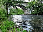 Railway bridge over Wda river in Czarna Woda
 -
 Municipal Library
 -
 Mickiewicza Street in Czarna Woda
 -
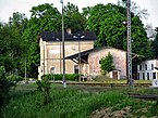 Railway station


References[edit]
- ^ a b "Czarna Woda (pomorskie)". Polska w liczbach (in Polish). Retrieved 23 October 2019.
- ^ a b "Local Data Bank". Statistics Poland. Retrieved 2022-07-27. Data for territorial unit 2213014.
| Urban gminas |
|  |
|---|---|---|
| Urban-rural gmina | ||
| Rural gminas | ||
This Pomeranian Voivodeship location article is a stub. You can help Wikipedia by expanding it. |