Druim Moir Historic District
Druim Moir Historic District | |
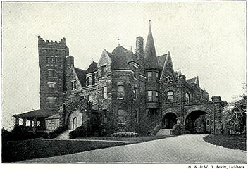
 Druim Moir castle | |
| Location | Bounded by Fairmount Park, Cherokee St., Hartwell Lane and Valley Green Rd., Philadelphia, Pennsylvania |
|---|---|
| Coordinates | 40°3′33″N 75°12′52″W / 40.05917°N 75.21444°W |
| Area | 47.5 acres (19.2 ha) |
| Built | 1886 |
| Architect | G. W. & W. D. Hewitt; Robert Rodes McGoodwin |
| Architectural style | Shingle Style, Romanesque, Picturesque Eclectic |
| NRHP reference No. | 79002318[1] |
| Added to NRHP | December 11, 1979 |
Druim Moir, also known as the Houston Estate Historic District, is a historic district in the Chestnut Hill neighborhood of Philadelphia, Pennsylvania.
Druim Moir was added to the National Register of Historic Places in 1979. It is a contributing property of the Chestnut Hill National Historic District.[2]
Contributing properties
The centerpiece of the historic district is Druim Moir Castle (1885–86), whose main gate is at the corner of Willow Grove Avenue and Cherokee Street. Designed by architects W.D. Hewitt and G.W. Hewitt, and built at a cost of over $115,000 for Henry H. Houston, the thirty-room home was the largest in its neighborhood. Local Wissahickon Schist was used for the walls, Eastern granite for the trim, and slate for the roof. The interior is notable for the variety of woods utilized: oak for the hall and stairway, butternut walnut for the parlor, mahogany for the reception room, quartered oak in the dining room and library, sycamore for the office, and cypress for the servant's section. Oak, cherry, and sycamore were used on the second floor, and white pine was used for the servants' quarters on the third floor. "Druim Moir" means Great Ridge in Gaelic.
Houston was the largest landowner in Philadelphia in the 1880s. He earned his wealth as the freight manager of the Pennsylvania Railroad, as well as from gold mining, shipping, and petroleum products. Houston also developed the neighborhood of over 80 homes known as Wissahickon Heights that surrounds Druim Moir.
Nearby Brinkwood, a Shingle-style residence, was a wedding present from Houston to his son, Samuel F. Houston, in 1887.
The gardens were altered in 1920-1921 by Robert Rodes McGoodwin for Samuel F. Houston. In 1952, the house was modified by the removal of the top story and towers.
In addition to the eponymous castle and Brinkwood, the historic district comprises five other contributing properties and eight non-contributing properties.
-
Druim Moir in 1901
-
Gateway to Druim Moir, built before 1904
References
- ^ "National Register Information System". National Register of Historic Places. National Park Service. March 13, 2009.
- ^ Webster, Richard J. (1979). "Druim Moir Historic District" (PDF). National Register of Historic Places Inventory-Nomination Form. Pennsylvania Historical and Museum Commission. Retrieved December 27, 2013.
External links
- Listing and photographs at Philadelphia Architects and Buildings
- Photograph of the castle in its original state at Bryn Mawr College
- Houses on the National Register of Historic Places in Pennsylvania
- Shingle Style architecture in Pennsylvania
- Neighborhoods in Philadelphia
- History of Philadelphia
- Historic districts in Philadelphia
- Chestnut Hill, Philadelphia
- Historic district contributing properties in Pennsylvania
- Houses in Philadelphia
- Historic districts on the National Register of Historic Places in Pennsylvania
- National Register of Historic Places in Philadelphia


