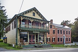
Durham, New York
Durham, New York | |
|---|---|
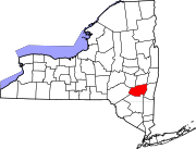
 Location in Greene County and the state of New York. | |
| Country | United States |
| State | New York |
| County | Greene |
| Government | |
| • Type | Town Council |
| • Town Supervisor | Gary J. Hulbert (R) |
| • Town Council | Members' List |
| Area | |
• Total | 49.3 sq mi (127.6 km2) |
| • Land | 49.2 sq mi (127.6 km2) |
| • Water | 0.0 sq mi (0.1 km2) |
| Elevation | 925 ft (282 m) |
| Population (2010) | |
• Total | 2,725 |
| Time zone | UTC-5 (Eastern (EST)) |
| • Summer (DST) | UTC-4 (EDT) |
| ZIP code | 12422 |
| Area code | 518 |
| FIPS code | 36-21204 |
| GNIS feature ID | 0978913 |


Durham is a town in Greene County, New York, United States. The population was 2,725 at the 2010 census. The town was named after Durham, Connecticut.
The Town of Durham is in the northwest corner of the county.
History
The town was first settled around 1755 within Albany County. The town was established from part of the Town of Coxsackie in 1790 as the "Town of Freehold." In the spring of 1800 Freehold became part of the newly formed Greene County. The town's name was changed to "Durham" in 1805, the town having been called informally "New Durham" by the many settlers from Connecticut.
Part of the town was lost to form, in 1803, the new Towns of Cairo, Greenville, and Windham. In 1836, the western part of Durham became the Town of Conesville in Schoharie County.
The first documented visit to the Durham area was by Eliab Youmans who had been commissioned to survey the Maitland patents in 1767. Undoubtedly, explorers, hunters, and trappers preceded Youmans, but their travels were unrecorded. The patents were the first official parceling out of the largely unclaimed land and were the precursors to settlement. Eight patents have been identified for lands that were in, or partly in the Town of Durham.
Historically, the Maitland Patent is the one most often cited, despite the fact that it was not one of the first grants. The grant, which was the first to lie exclusively in the future Town of Durham, is historically significant as being the location for land described in the first known recorded lease in Durham and thus contains the first documentation for the initial settlement of the town. This patent of 5,000 acres was made to Colonel Richard Maitland, a British army officer of Scottish birth. The patent encompassed land that now includes the Oak Hill area as well as surrounding farmland leased by the earliest settlers. The first known lease was to Lucas DeWitt, dated May 3, 1774, for property in "DeWittsburg". The language of that lease suggests an occupation of the land by the earlier settlers, perhaps by 1771. In the early nineteenth century, Oak Hill matured into a vigorous industrial hamlet with highly productive mills and many fashionable homes.
The establishment of the first settlement in Durham is credited to three men, Lucas DeWitt, John Plank, and Hendrick Plank. These pioneers established homes at what was then called DeWittsburg, now Oak Hill. The Revolution forced the pioneers to temporarily abandon their homes until the end of the war. Hendrick Plank was abducted by the Native Americans and removed to Canada where he died in captivity. The two remaining pioneers and Hendrick's widow, who remarried to Leonard Patrie, all returned by about 1782 to reestablish their homes. DeWitt brought with him, a small hand mill for grinding grain and was in one respect the first miller in the town as well as being a farmer.
Geography
According to the United States Census Bureau, the town has a total area of 49.3 square miles (128 km2), of which, 49.2 square miles (127 km2) of it is land and 0.04 square miles (0.10 km2) of it (0.04%) is water.
The north town line is the border of Albany County, New York, and part of the west town line is the border of Schoharie County, New York.
Demographics
| Census | Pop. | Note | %± |
|---|---|---|---|
| 1820 | 2,979 | — | |
| 1830 | 3,039 | 2.0% | |
| 1840 | 2,813 | −7.4% | |
| 1850 | 2,600 | −7.6% | |
| 1860 | 2,558 | −1.6% | |
| 1870 | 2,257 | −11.8% | |
| 1880 | 2,173 | −3.7% | |
| 1890 | 1,925 | −11.4% | |
| 1900 | 1,636 | −15.0% | |
| 1910 | 1,475 | −9.8% | |
| 1920 | 1,211 | −17.9% | |
| 1930 | 1,104 | −8.8% | |
| 1940 | 1,223 | 10.8% | |
| 1950 | 1,233 | 0.8% | |
| 1960 | 1,313 | 6.5% | |
| 1970 | 1,651 | 25.7% | |
| 1980 | 2,283 | 38.3% | |
| 1990 | 2,324 | 1.8% | |
| 2000 | 2,592 | 11.5% | |
| 2010 | 2,725 | 5.1% | |
| 2014 (est.) | 2,676 | [1] | −1.8% |
As of the census[3] of 2000, there were 2,592 people, 1,046 households, and 718 families residing in the town. The population density was 52.6 people per square mile (20.3/km²). There were 1,642 housing units at an average density of 33.3 per square mile (12.9/km²). The racial makeup of the town was 98.38% White, 0.08% African American, 0.31% Native American, 0.42% Asian, 0.08% from other races, and 0.73% from two or more races. Hispanic or Latino of any race were 1.35% of the population.
There were 1,046 households out of which 28.6% had children under the age of 18 living with them, 56.1% were married couples living together, 8.0% had a female householder with no husband present, and 31.3% were non-families. 25.3% of all households were made up of individuals and 12.4% had someone living alone who was 65 years of age or older. The average household size was 2.44 and the average family size was 2.91.
In the town the population was spread out with 23.0% under the age of 18, 6.3% from 18 to 24, 25.0% from 25 to 44, 28.2% from 45 to 64, and 17.5% who were 65 years of age or older. The median age was 42 years. For every 100 females there were 99.7 males. For every 100 females age 18 and over, there were 97.8 males.
The median income for a household in the town was $34,282, and the median income for a family was $41,875. Males had a median income of $34,821 versus $22,292 for females. The per capita income for the town was $18,705. About 9.8% of families and 11.5% of the population were below the poverty line, including 9.0% of those under age 18 and 7.0% of those age 65 or over.
Communities and locations in Durham
- Cornwallville — A hamlet south of Durham village on Route 20. It is the location of the Moore Road Stone Arch Bridge and Shady Glen Road Stone Arch Bridge, listed on the National Register of Historic Places in 2008.[4]
- Durso Corner — A hamlet east of East Windham on Route 23.
- Durham — the hamlet of Durham in the north part of the town on Route 145.
- East Durham — A hamlet southeast of Durham village on Route 145.
- East Windham — A hamlet at the south town line on Route 23.
- Hervey Street — A hamlet near the south town line. It is the location of the Hervey Street Road Stone Arch Bridge, listed on the National Register of Historic Places in 2008.[4]
- Mount Pisgah — An elevation at the west town line.
- Oak Hill — A hamlet northeast of Durham village, located on Route 81.
- Sunside — A hamlet in the southeast part of the town.
- South Durham — A hamlet in the southeast part of the town on Route 23.
- West Durham — A hamlet near the west town line on Route 20.
Notable people
- John Adams, (1778–1854), United States Congressman from New York, taught school and practiced law here.[5]
- The Reverend Dwight Baldwin, (1798–1886), Missionary in Hawaii, born in Durham, CT, raised in Durham, NY.
- Blossom Dearie grew up in East Durham.
- Alfred W. Newman, (1834–1898), Wisconsin Supreme Court[6]
References
- ^ "Annual Estimates of the Resident Population for Incorporated Places: April 1, 2010 to July 1, 2014". Retrieved June 4, 2015.
- ^ "Census of Population and Housing". Census.gov. Retrieved June 4, 2015.
- ^ "American FactFinder". United States Census Bureau. Retrieved 2008-01-31.
- ^ a b "National Register Information System". National Register of Historic Places. National Park Service. March 13, 2009.
- ^ Who Was Who in America, Historical Volume, 1607-1896. Chicago: Marquis Who's Who. 1963.
- ^ http://www.wicourts.gov/about/judges/supreme/retired/newman.htm

