Equator (schooner)

| |
| History | |
|---|---|
| Builder | Mathew Turner |
| Launched | 1888 |
| Out of service | Abandoned (1956) |
| Status | Museum ship |
| General characteristics | |
| Installed power |
|
| Sail plan | Schooner |
Equator (schooner) | |
| Location | 14th St. Yacht Basin Everett, Washington, United States |
| Coordinates | 48°00′14″N 122°13′05″W / 48.00389°N 122.21806°W |
| Built | 1888 |
| Architect | Matthew Turner |
| NRHP reference No. | 72001281[1] |
| Added to NRHP | 14April 1972 |
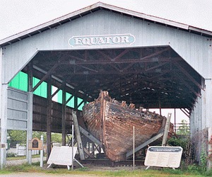
Equator was a two-masted pygmy trading schooner that in 1889 carried passengers Robert Louis Stevenson and Fanny Vandegrift Stevenson on a voyage through the islands of Micronesia. They visited Butaritari, Mariki, Apaiang and Abemama in the Gilbert Islands, (also known as the Kingsmills) now Kiribati.[2] Photographs of Stevenson's voyage exist.
Originally built in San Francisco in 1888 as a copra trader, Equator was converted to steam in 1897 and eventually abandoned in the harbor at Everett, Washington in 1957. The vessel was Everett's first artifact placed on the National Register of Historic Places in 1972. The remains of the hull are protected by a shed near the Port of Everett's Marina Park. Several attempts to rebuild the ship have failed, and restoration is considered unlikely. Built in Benicia, California, she is the last surviving hull of that time period known to exist. In her career she worked under sail, steam, gasoline, and diesel power. She worked copra, fish, tug and support for the Geodetic Survey. Because of her shoal draft she could get close on shore where other vessels couldn't go.
See also
References
- ^ "National Register Information System". National Register of Historic Places. National Park Service. July 9, 2010.
- ^ Stevenson, Robert Louis. In the South Seas (pdf). A collection of Stevenson's articles and essays on his travels in the Pacific
- "National Register of Historic Places Inventory – Nomination Form" (pdf). National Park Service. 24 November 1969.
- "Accompanying Photos" (pdf). National Park Service. Retrieved 2012-08-30.
External links
- "Schooner Equator" (pdf). Historic American Engineering Record. National Park Service. HAER WA-206.
- Equator at the Historic Everett Waterfront
- Silverado Museum, California, devoted to Robert Louis Stevenson
- The Writers' Museum, Edinburgh, Scotland, The United Kingdom, which holds photographs and documents of Robert Louis Stevenson
- 1888 ships
- Everett, Washington
- Merchant ships of the United States
- Museum ships in Washington (state)
- National Register of Historic Places in Washington (state)
- Robert Louis Stevenson
- Schooners
- Ships on the National Register of Historic Places in Washington (state)
- National Register of Historic Places in Snohomish County, Washington

