
Dugandan railway line
| Dugandan railway line | ||||||||||||||||||||||||||||||||||||||||||||||||||||||||||||||||||||||||||||||||||||||||||||||||||||||||||||||||||||||||||||||||||||||||||||||||||||||||||||||||||||||||||||||||||||||||||||||||||||||||||||||||||||||||||||||||
|---|---|---|---|---|---|---|---|---|---|---|---|---|---|---|---|---|---|---|---|---|---|---|---|---|---|---|---|---|---|---|---|---|---|---|---|---|---|---|---|---|---|---|---|---|---|---|---|---|---|---|---|---|---|---|---|---|---|---|---|---|---|---|---|---|---|---|---|---|---|---|---|---|---|---|---|---|---|---|---|---|---|---|---|---|---|---|---|---|---|---|---|---|---|---|---|---|---|---|---|---|---|---|---|---|---|---|---|---|---|---|---|---|---|---|---|---|---|---|---|---|---|---|---|---|---|---|---|---|---|---|---|---|---|---|---|---|---|---|---|---|---|---|---|---|---|---|---|---|---|---|---|---|---|---|---|---|---|---|---|---|---|---|---|---|---|---|---|---|---|---|---|---|---|---|---|---|---|---|---|---|---|---|---|---|---|---|---|---|---|---|---|---|---|---|---|---|---|---|---|---|---|---|---|---|---|---|---|---|---|---|---|---|---|---|---|---|---|---|---|---|---|---|---|---|
 Dugandan Railway Station, near Boonah, circa 1930 | ||||||||||||||||||||||||||||||||||||||||||||||||||||||||||||||||||||||||||||||||||||||||||||||||||||||||||||||||||||||||||||||||||||||||||||||||||||||||||||||||||||||||||||||||||||||||||||||||||||||||||||||||||||||||||||||||
| Overview | ||||||||||||||||||||||||||||||||||||||||||||||||||||||||||||||||||||||||||||||||||||||||||||||||||||||||||||||||||||||||||||||||||||||||||||||||||||||||||||||||||||||||||||||||||||||||||||||||||||||||||||||||||||||||||||||||
| Other name(s) | Fassifern railway line Churchill branch railway | |||||||||||||||||||||||||||||||||||||||||||||||||||||||||||||||||||||||||||||||||||||||||||||||||||||||||||||||||||||||||||||||||||||||||||||||||||||||||||||||||||||||||||||||||||||||||||||||||||||||||||||||||||||||||||||||
| Locale | Queensland, Australia | |||||||||||||||||||||||||||||||||||||||||||||||||||||||||||||||||||||||||||||||||||||||||||||||||||||||||||||||||||||||||||||||||||||||||||||||||||||||||||||||||||||||||||||||||||||||||||||||||||||||||||||||||||||||||||||||
| History | ||||||||||||||||||||||||||||||||||||||||||||||||||||||||||||||||||||||||||||||||||||||||||||||||||||||||||||||||||||||||||||||||||||||||||||||||||||||||||||||||||||||||||||||||||||||||||||||||||||||||||||||||||||||||||||||||
| Opened | 1882 | |||||||||||||||||||||||||||||||||||||||||||||||||||||||||||||||||||||||||||||||||||||||||||||||||||||||||||||||||||||||||||||||||||||||||||||||||||||||||||||||||||||||||||||||||||||||||||||||||||||||||||||||||||||||||||||||
| Closed | 1964 | |||||||||||||||||||||||||||||||||||||||||||||||||||||||||||||||||||||||||||||||||||||||||||||||||||||||||||||||||||||||||||||||||||||||||||||||||||||||||||||||||||||||||||||||||||||||||||||||||||||||||||||||||||||||||||||||
| Technical | ||||||||||||||||||||||||||||||||||||||||||||||||||||||||||||||||||||||||||||||||||||||||||||||||||||||||||||||||||||||||||||||||||||||||||||||||||||||||||||||||||||||||||||||||||||||||||||||||||||||||||||||||||||||||||||||||
| Line length | 35 mi 28 chains (56.9 km) | |||||||||||||||||||||||||||||||||||||||||||||||||||||||||||||||||||||||||||||||||||||||||||||||||||||||||||||||||||||||||||||||||||||||||||||||||||||||||||||||||||||||||||||||||||||||||||||||||||||||||||||||||||||||||||||||
| ||||||||||||||||||||||||||||||||||||||||||||||||||||||||||||||||||||||||||||||||||||||||||||||||||||||||||||||||||||||||||||||||||||||||||||||||||||||||||||||||||||||||||||||||||||||||||||||||||||||||||||||||||||||||||||||||
The Dugandan railway line was a branch railway in the Scenic Rim region of South East Queensland, Australia. It was also known as the Fassifern railway line. It operated from 1882 to 1964.[1]
Geography[edit]
The line began west of Ipswich station on the Main Line 39 km west of Brisbane and proceeded generally southward for approximately 50 km to the locality of Dugandan now part of the urban settlement of Boonah.
History[edit]
Residents in the Fassifern Valley petitioned the Queensland Government to build a railway line to their district, and the first section was opened on 10 July 1882 as far as Harrisville. This is considered to be Queensland's first branch railway. The branch was extended to Dugandan on 12 September 1887.[1][2]
The Mount Edwards branch line branched off the Dugandan line at Munbilla. The Mount Edwards line opened to Kalbar on 17 April 1916 and to Mount Edwards on 7 October 1922. The Mount Edwards line closed in 1960.[3][4]
During its life, the Dugandan branch carried mixed traffic, including goods trains, mixed trains and rail motors.[2]
The Dugandan branch was closed beyond the Churchill railway station on 30 June 1964 due to increasing competition from road transport.[2][5] The small remaining section was known as the Churchill branch railway.[6]
Route[edit]
Legacy[edit]

There is a memorial to the railway line in Yeates Street, Boonah at the back of the Commercial Hotel (27°59′50″S 152°40′54″E / 27.99714°S 152.68176°E). The memorial is on the site of the former Boonah railway station.[16]
Some evidence of the line's existence remains today. An embankment which carried the railway over a floodplain immediately north of Boonah is still readily visible from the Boonah-Fassifern Road. The station building at Harrisville is still intact, as is a small cutting immediately south of Harrisville station. Part of the alignment between Boonah and Dugandan along a cut-and-fill embankment is now a paved footpath through an urban park.
As of 2009, the Scenic Rim Region is developing a rail trail in partnership with the Queensland state government. The trail for the use of bushwalkers, cyclists and horse riders will follow some of the former alignment between Ipswich and Boonah.[17]
Gallery[edit]
-
 Harrisville railway station
 -
 Shallow railway cutting in Harrisville
 -
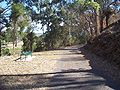 Former track formation between Boonah and Dugandan with a cutting on the right, now a footpath through a park


See also[edit]
References[edit]
- ^ a b Kerr, John (1990). Triumph of narrow gauge : a history of Queensland Railways. Boolarong Publications. pp. 57–58, 224. ISBN 978-0-86439-102-5.
- ^ a b c Johnson, M.; Saunders, K. (2007). "Working The Land: An historical overview of Boonah and its northern district" (PDF). State of Queensland. Archived (PDF) from the original on 29 September 2009. Retrieved 24 October 2009.
- ^ QR Limited. "Rail as foremost mode of travel". Archived from the original on 12 September 2009. Retrieved 25 October 2009.
- ^ Southern Downs Steam Railway (2009). "'Via recta' – The line that never was". Archived from the original on 12 September 2009. Retrieved 25 October 2009.
- ^ Fassifern Branch Railway Memorial, Boonah, 31 May 2020, archived from the original on 22 December 2020, retrieved 8 June 2020
- ^ "1880s". Queensland Rail. Retrieved 9 June 2020.
- ^ a b c d e f g h i "Map 40: Two-mile series" (Map). Queensland Government. 1952. Archived from the original on 8 June 2020. Retrieved 9 June 2020.
- ^ "Ipswich – railway station in City of Ipswich (entry 39186)". Queensland Place Names. Queensland Government. Retrieved 9 June 2020.
- ^ "Little Ipswich – railway station in City of Ipswich (entry 19597)". Queensland Place Names. Queensland Government. Retrieved 9 June 2020.
- ^ Gregory's Street Directory of Brisbane and Suburbs and Metropolitan Road Guide (11 ed.). 1975. pp. Map 111 H10.
- ^ "Churchill – railway station in City of Ipswich (entry 7229)". Queensland Place Names. Queensland Government. Retrieved 9 June 2020.
- ^ a b c d e f g h i j k l m n o p q "Flinders" (Map). Queensland Government. 1927. Archived from the original on 29 May 2020. Retrieved 29 May 2020.
- ^ a b c d e f g h i j k l m n o p q "Map 38: Two-mile series" (Map). Queensland Government. 1946. Archived from the original on 8 June 2020. Retrieved 9 June 2020.
- ^ "Dugandan" (Map). Queensland Government. 1935. Archived from the original on 30 May 2020. Retrieved 30 May 2020.
- ^ "Towns of Boonah and Dugandan" (Map). Queensland Government. 1981. Archived from the original on 30 May 2020. Retrieved 30 May 2020.
- ^ Fassifern Branch Railway Memorial, 18 April 1982, archived from the original on 22 December 2020, retrieved 30 May 2020
- ^ Scenic Rim Region. "SEQ Regional Recreational Trails Program". Archived from the original on 12 July 2017. Retrieved 25 October 2009.
External links[edit]
| |||||
| |||||
|