
File:Anjouan topographic map-fr.svg

Size of this PNG preview of this SVG file: 734 × 600 pixels. Other resolutions: 294 × 240 pixels | 588 × 480 pixels | 940 × 768 pixels | 1,254 × 1,024 pixels | 2,507 × 2,048 pixels | 841 × 687 pixels.
Original file (SVG file, nominally 841 × 687 pixels, file size: 764 KB)
| This is a file from the Wikimedia Commons. Information from its description page there is shown below. Commons is a freely licensed media file repository. You can help. |
Summary
| Camera location | | View this and other nearby images on: OpenStreetMap |
|---|
| Description |
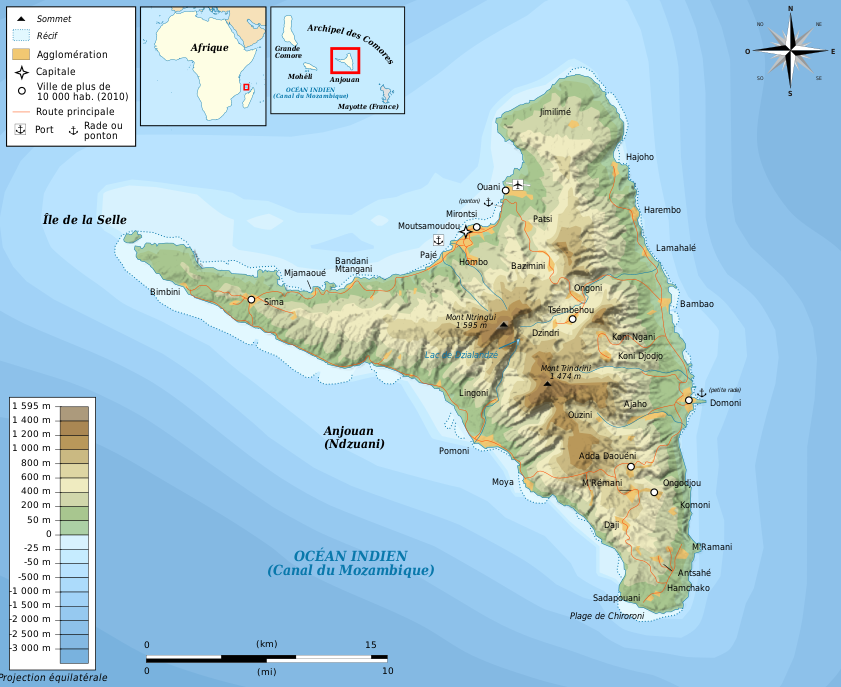
Français : Carte topographique en français d'Anjouan Deutsch: Topographische Karte zum Anjouan, in Französische English: Topographic map in French language of Anjouan Español: Mapa topográfico en francès de Anjouan Italiano: Carta topografica de Anjouan 日本語: フランス語で表示したアンジュアン島の地形地図 Português: Carta topográfica e da administração do Anjouan em francês |
||||
| Date | |||||
| Source |
Création personnelle ;
|
||||
| Author | Bourrichon - fr:Bourrichon | ||||
| Permission (Reusing this file) |
I, the copyright holder of this work, hereby publish it under the following licenses:
This file is licensed under the Creative Commons Attribution-Share Alike 3.0 Unported, 2.5 Generic, 2.0 Generic and 1.0 Generic license.
You may select the license of your choice. |
||||
| Other versions |
Derivative works of this file: Template:Other versions/Anjouan map |


|
This SVG file contains embedded text that can be translated into your language, using any capable SVG editor, text editor or the SVG Translate tool. For more information see: About translating SVG files. |
This W3C-unspecified vector image was created with Inkscape .
File history
Click on a date/time to view the file as it appeared at that time.
| Date/Time | Thumbnail | Dimensions | User | Comment | |
|---|---|---|---|---|---|
| current | 19:54, 14 March 2011 | | 841 × 687 (764 KB) | Bourrichon | |
| 20:31, 13 March 2011 |  | 841 × 687 (763 KB) | Bourrichon | ||
| 15:40, 13 March 2011 |  | 841 × 687 (763 KB) | Bourrichon | {{Location|12|13|30|S|44|22|30|E|scale:500000}} {{Information |Description= {{fr|Carte topographique en français d'fr:Anjouan}}{{de|Topographische Karte zum de:Anjouan, in Französische}}{{en|Topographic map in French language of [[:en:Anjoua |
File usage
The following pages on the English Wikipedia use this file (pages on other projects are not listed):
Global file usage
The following other wikis use this file:
- Usage on br.wikipedia.org
- Usage on de.wikipedia.org
- Usage on eo.wikipedia.org
- Usage on es.wikipedia.org
- Usage on frr.wikipedia.org
- Usage on fr.wikipedia.org
- Usage on mg.wikipedia.org
- Usage on nl.wikipedia.org
- Usage on tr.wikipedia.org
- Usage on vi.wikipedia.org