
File:Atlas of Door County, Wisconsin LOC 2008622055-7.jpg

Size of this preview: 800 × 534 pixels. Other resolutions: 320 × 213 pixels | 640 × 427 pixels | 1,024 × 683 pixels | 1,280 × 854 pixels | 2,560 × 1,708 pixels | 9,176 × 6,121 pixels.
Original file (9,176 × 6,121 pixels, file size: 6.95 MB, MIME type: image/jpeg)
| This is a file from the Wikimedia Commons. Information from its description page there is shown below. Commons is a freely licensed media file repository. You can help. |
Summary
| Description |
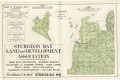
English: LeGear. Atlases of the United States, 6490 Includes index and advertisements. Available also through the Library of Congress Web site as a raster image. LC copy imperfect: Losses to p. 7-8. Vendor: John Carbonell Acquisitions control no. 2008-087 |
||
| Title | Atlas of Door County, Wisconsin | ||
| Shelf ID | G1418.D6 N4 1914 | ||
| Parent | https://www.loc.gov/resource/g4123dm.gla00155/ | ||
| Sheet title | Map of Chambers Island; Map of Gibralter | ||
| Date | |||
| Source | https://www.loc.gov/item/2008622055/ | ||
| Author | Nelson, Otto | ||
| Permission (Reusing this file) |
|
||
| Other versions |
|
||
| Location | United States · Wisconsin · Door County | ||
| Part of | American Memory · Catalog · County Landownership Maps · Geography And Map Division · Cultural Landscapes | ||
| Subject | Atlases · Door County (Wis.) · Directories · Landowners · United States · Maps · Wisconsin · Real Property · Door County |

Licensing
|
This is a faithful photographic reproduction of a two-dimensional, public domain work of art. The work of art itself is in the public domain for the following reason:
The official position taken by the Wikimedia Foundation is that "faithful reproductions of two-dimensional public domain works of art are public domain".
This photographic reproduction is therefore also considered to be in the public domain in the United States. In other jurisdictions, re-use of this content may be restricted; see Reuse of PD-Art photographs for details. | ||||
File history
Click on a date/time to view the file as it appeared at that time.
| Date/Time | Thumbnail | Dimensions | User | Comment | |
|---|---|---|---|---|---|
| current | 09:56, 31 May 2018 | | 9,176 × 6,121 (6.95 MB) | Fæ | LOC Maps multisheet https://www.loc.gov/item/2008622055/ sheet 7 of 18 #12019 |
File usage
The following pages on the English Wikipedia use this file (pages on other projects are not listed):
Global file usage
The following other wikis use this file:
- Usage on es.wikipedia.org
- Usage on fr.wikipedia.org
- Usage on ro.wikipedia.org